Industrial archaeology of Dartmoor

Last updated

The remains of the wheelpit at Huntingdon mine on southern Dartmoor Huntingdon wheelpit2.jpg
The remains of the wheelpit at Huntingdon mine on southern Dartmoor

The industrial archaeology of Dartmoor covers a number of the industries which have, over the ages, taken place on Dartmoor, and the remaining evidence surrounding them. Currently only three industries are economically significant, yet all three will inevitably leave their own traces on the moor: china clay mining, farming and tourism.

Contents

A good general guide to the commercial activities on Dartmoor at the end of the 19th century is William Crossing's The Dartmoor Worker.

Mining

The Wheal Betsy engine house 050715 101 uk dev betsy.jpg
The Wheal Betsy engine house

In former times, lead, silver, tin and copper were mined extensively on Dartmoor. The most obvious evidence of mining to the casual visitor to Dartmoor are the remains of the old engine-house at Wheal Betsy which is alongside the A386 road between Tavistock and Okehampton. The word Wheal has a particular meaning in Devon and Cornwall being either a tin or a copper mine, however in the case of Wheal Betsy it was principally lead and silver which were mined.

Once widely practised by many miners across the moor, by the early 1900s only a few tinners remained, and mining had almost completely ceased twenty years later. Some of the more significant mines were Eylesbarrow, Knock Mine, Vitifer Mine and Hexworthy Mine. The last active mine in the Dartmoor area was Great Rock Mine, which shut down in 1969. [1]

One of the granite quarries near Haytor 050715 043 uk dev quarry.jpg
One of the granite quarries near Haytor

Quarrying

Dartmoor granite has been used in many Devon and Cornish buildings. The prison at Princetown was built from granite taken from Walkhampton Common. When the horse tramroad from Plymouth to Princetown was completed in 1823, large quantities of granite were more easily transported.

There were three major granite quarries on the moor: Haytor, Foggintor and Merrivale. The granite quarries around Haytor were the source of the stone used in several famous structures, including the New London Bridge, completed in 1831. This granite was transported from the moor via the Haytor Granite Tramway, stretches of which are still visible.

The extensive quarries at Foggintor provided granite for the construction of London's Nelson's Column in the early 1840s, and New Scotland Yard was faced with granite from the quarry at Merrivale. [2] Merrivale Quarry continued excavating and working its own granite until the 1970s, producing gravestones and agricultural rollers. Work at Merrivale continued until the 1990s, for the last 20 years imported stone such as gabbro from Norway and Italian marble was dressed and polished. [3] The unusual pink granite at Great Trowlesworthy Tor was also quarried, and there were many other small granite quarries dotted around the moor. Various metamorphic rocks were also quarried in the metamorphic aureole around the edge of the moor, most notably at Meldon. [4]

Gunpowder factory

One of the incorporating mills at Powdermills Powdermills incorporating mill01.jpg
One of the incorporating mills at Powdermills

In 1844 a factory for making gunpowder was built on the open moor, not far from Postbridge. Gunpowder was needed for the tin mines and granite quarries then in operation on the moor. The buildings were widely spaced from one another for safety and the mechanical power for grinding ("incorporating") the powder was derived from waterwheels driven by a leat.

Now known as "Powdermills" or "Powder Mills", there are extensive remains of this factory still visible. Two chimneys still stand and the walls of the two sturdily-built incorporating mills with central waterwheels survive well: they were built with substantial walls but flimsy roofs so that in the event of an explosion, the force of the blast would be directed safely upwards. The ruins of a number of ancillary buildings also survive. A proving mortar—a type of small cannon used to gauge the strength of the gunpowder—used by the factory still lies by the side of the road to the nearby pottery. [5]

Peat-cutting

Peat-cutting for fuel occurred at some locations on Dartmoor until certainly the 1970s, usually for personal use. The right of Dartmoor commoners to cut peat for fuel is known as turbary. These rights were conferred a long time ago, pre-dating most written records. The area once known as the Turbary of Alberysheved between the River Teign and the headwaters of the River Bovey is mentioned in the Perambulation of the Forest of Dartmoor of 1240 (by 1609 the name of the area had changed to Turf Hill).

An attempt was made to commercialise the cutting of peat in 1901 at Rattle Brook Head, however this quickly failed.

Warrens

From at least the 13th century until early in the 20th, rabbits were kept on a commercial scale, both for their flesh and their fur. Documentary evidence for this exists in place names such as Trowlesworthy Warren (mentioned in a document dated 1272) and Warren House Inn. The physical evidence, in the form of pillow mounds is also plentiful, for example there are 50 pillow mounds at Legis Tor Warren. [6] The sophistication of the warreners is shown by the existence of vermin traps that were placed near the warrens to capture weasels and stoats attempting to get at the rabbits.

The significance of the term warren nowadays is not what it once was. In the Middle Ages it was a privileged place, and the creatures of the warren were protected by the king 'for his princely delight and pleasure'.

The subject of warrening on Dartmoor was addressed in Eden Phillpotts' story The River.

Farming

Farming has been practised on Dartmoor since time immemorial. The dry-stone walls which separate fields and mark boundaries give an idea of the extent to which the landscape has been shaped by farming. There is little or no arable farming within the moor, mostly being given over to livestock farming on account of the thin and rocky soil. Some Dartmoor farms are remote in the extreme.

See also

Related Research Articles

<span class="mw-page-title-main">Dartmoor</span> National park in South West England

Dartmoor is an upland area in southern Devon, South West England. The moorland and surrounding land has been protected by National Park status since 1951. Dartmoor National Park covers 954 km2 (368 sq mi).

<span class="mw-page-title-main">Merrivale, Devon</span> Village in Devon, England

Merrivale is a locality in western Dartmoor, in the West Devon district of Devon, England. It is best known for the nearby series of Bronze Age megalithic monuments to the south and a former granite quarry.

<span class="mw-page-title-main">Ilsington</span> Village and civil parish in Devon, England

Ilsington is a village and civil parish situated on the eastern edge of Dartmoor, Devon, England. It is one of the largest parishes in the county, and includes the villages of Ilsington, Haytor Vale, Liverton and South Knighton. The parish is surrounded, clockwise from the north, by the parishes of Bovey Tracey, Teigngrace, Newton Abbot, Ogwell, Bickington, Ashburton, Widecombe-in-the-Moor and Manaton. In 2001 the population of the parish was 2,444, greatly increased from the 886 residents recorded in 1901. The parish is represented in parliament by Mel Stride, as part of the Central Devon constituency.

<span class="mw-page-title-main">Dartmoor tin mining</span>

The tin mining industry on Dartmoor, Devon, England, is thought to have originated in pre-Roman times, and continued right through to the 20th century, when the last commercially worked mine closed in November 1930. From the 12th century onwards tin mining was regulated by a stannary parliament which had its own laws.

<span class="mw-page-title-main">Dartmoor National Park Authority</span> English national park authority

The Dartmoor National Park Authority (DNPA) is a national park authority in England, legally responsible for Dartmoor in Devon. It came into existence in its present form in 1997, being preceded by a committee of Devon County Council and the Dartmoor National Park Committee from 1 April 1974.

<span class="mw-page-title-main">Haytor</span> Granite tor on Dartmoor in Devon, England

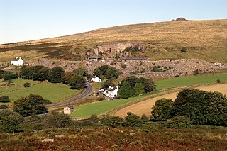
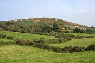
Haytor, also known as Haytor Rocks, Hay Tor, or occasionally Hey Tor, is a granite tor on the eastern edge of Dartmoor in the English county of Devon.

<span class="mw-page-title-main">Mining in Cornwall and Devon</span> Mining in the English counties of Cornwall and Devon

Mining in Cornwall and Devon, in the southwest of Britain, is thought to have begun in the early-middle Bronze Age with the exploitation of cassiterite. Tin, and later copper, were the most commonly extracted metals. Some tin mining continued long after the mining of other metals had become unprofitable, but ended in the late 20th century. In 2021, it was announced that a new mine was extracting battery-grade lithium carbonate, more than 20 years after the closure of the last South Crofty tin mine in Cornwall in 1998.

<span class="mw-page-title-main">Blowing house</span> Tin smelting building formerly used in southwest England

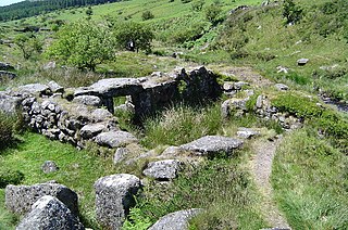
A blowing house or blowing mill was a building used for smelting tin in Cornwall and on Dartmoor in Devon, in South West England. Blowing houses contained a furnace and a pair of bellows that were powered by an adjacent water wheel, and they were in use from the early 14th century until they were gradually replaced by reverberatory furnaces in the 18th century. The remains of over 40 blowing houses have been identified on Dartmoor.

<span class="mw-page-title-main">Geology of Cornwall</span>

The geology of Cornwall, England, is dominated by its granite backbone, part of the Cornubian batholith, formed during the Variscan orogeny. Around this is an extensive metamorphic aureole formed in the mainly Devonian slates that make up most of the rest of the county. There is an area of sandstone and shale of Carboniferous age in the north east, and the Lizard peninsula is formed of a rare section of uplifted oceanic crust.

<span class="mw-page-title-main">Haytor Granite Tramway</span> Horse-drawn tramway built to convey granite (1820-1858)

The Haytor Granite Tramway was a tramway built to convey granite from Haytor Down, Dartmoor, Devon to the Stover Canal. It was very unusual in that the track was formed of granite sections, shaped to guide the wheels of horse-drawn wagons.

<span class="mw-page-title-main">Whiteworks</span> Former mining hamlet in Devon, England

Whiteworks is a former mining hamlet near the town of Princetown, within Dartmoor National Park, in the English county of Devon. Tin mining is central to the history of settlement at Whiteworks, which was once home to one of Dartmoor's largest tin mines. The original cottages and their inhabitants were related to this industry, until the area became used increasingly for farming in the 20th century. The site has now largely been abandoned, although Whiteworks is still on the route of many walks including Abbots Way Walk passes 500 m to the west.

<span class="mw-page-title-main">Tavistock Canal</span> Canal in Devon, England

The Tavistock Canal is a canal in the county of Devon in England. It was constructed early in the 19th century to link the town of Tavistock to Morwellham Quay on the River Tamar, where cargo could be loaded into ships. The canal is still in use to supply water to a hydro-electric power plant at Morwellham Quay, and forms part of the Cornwall and West Devon Mining Landscape World Heritage Site. It is unusual for a canal, as it has a gentle slope over its length, resulting in a considerable flow of water.

<span class="mw-page-title-main">Plymouth and Dartmoor Railway</span>

The Plymouth and Dartmoor Railway (P&DR) was a 4 ft 6 in gauge railway built to improve the economy of moorland areas around Princetown in Devon, England. Independent carriers operated horse-drawn wagons and paid the company a toll. It opened in 1823, and a number of short branches were built in the next few years.

<span class="mw-page-title-main">Eylesbarrow mine</span> Disused tin mine on Dartmoor, Devon, England

Eylesbarrow mine was a tin mine on Dartmoor, Devon, England that was active during the first half of the 19th century. In its early years it was one of the largest and most prosperous of the Dartmoor tin mines, along with Whiteworks and the Birch Tor and Vitifer mines. Its name has several variant spellings, such as Eylesburrow, Ailsborough, Ellisborough, Hillsborough etc. It was also known as Wheal Ruth for a short period around 1850. The extensive remains lie to the north of the River Plym, less than 1 mile (1.6 km) north-east of Drizzlecombe, on the southern shoulder of the hill called Eylesbarrow on top of which are two prominent Bronze Age barrows.

<span class="mw-page-title-main">Birch Tor and Vitifer mine</span> Former tin mine in Devon, England

Birch Tor and Vitifer mine was a tin mine on Dartmoor, Devon, England. Located in the valley of the Redwater Brook, to the east of the B3212 Moretonhampstead to Princetown road, below the Warren House Inn, the mine was worked between the mid–18th century and 1925.

<span class="mw-page-title-main">Trencrom Hill</span> Hillfort in Cornwall, England

Trencrom Hill is a prominent hill fort, owned by the National Trust, near Lelant, Cornwall. It is crowned by an univallate Neolithic tor enclosure and was re-used as a hillfort in the Iron Age. Cairns or hut circles can be seen in the level area enclosed by the stone and earth banks. The hill overlooks the Hayle Estuary and river, and Mount's Bay and St Michael's Mount can be seen to the south. The hill was recorded as Torcrobm in 1758 which is derived from Cornish "torr crobm", i.e. 'hunched bulge'.

Wheal Metal is a tin-mining sett in west Cornwall, England, UK. Whilst not as famous as neighbouring Wheal Vor, it was thus described by the Mining Journal in July 1885: " Truly this is a wonderful mine—probably the richest tin mine in the world." It also hosts a very remarkable engine house of the mid-19th century that once stood over Trelawney's shaft on Wheal Vor, and since the Wheal Vor area itself has no visible remains, this is the only large surviving engine house of this group of mines which accounted for over a quarter of Cornish tin production in the mid-19th century.

This article describes the geology of Dartmoor National Park in Devon, in south-west England. Dartmoor gained national park status in 1951 but the designated area of 954 km2 (368 sq mi) extends beyond the upland of Dartmoor itself to include much of the surrounding land, particularly in the northeast. The geology of the national park consists of a 625 km2 (241 sq mi) core of granite intruded during the early Permian period into a sequence of sedimentary rocks originating in the Devonian and Carboniferous periods. These rocks were faulted and folded, sometimes, intensely, during the Variscan orogeny. Thermal metamorphism has also taken place around the margins of the granite pluton altering the character of the sedimentary rocks whilst mineral veins were emplaced within the granite. A small outlier of Palaeogene sediments occurs on the eastern boundary of the national park.

References

  1. The Uses of Dartmoor Rock Archived 2007-09-27 at the Wayback Machine . Dartmoor National Park Authority. Retrieved on 2007-06-15.
  2. Mercer 2009, pp.270–271
  3. Mercer 2009, pp.271–272
  4. Mercer 2009, p.273
  5. Sandles, Tim. "Dartmoor Powdermills". Legendary Dartmoor. Archived from the original on 21 November 2010. Retrieved 25 August 2010.
  6. Mercer 2009, pp.296–298

Sources