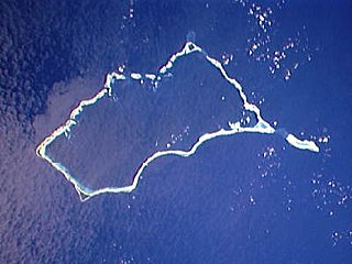
Mili Atoll is a coral atoll of 92 islands in the Pacific Ocean, and forms a legislative district of the Ratak Chain of the Marshall Islands. It is located approximately 78 kilometers (48 mi) southeast of Arno. Its total land area is 14.9 square kilometers (5.8 sq mi) making it the second largest of the Marshall Islands after Kwajalein.
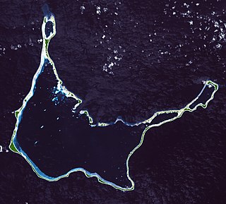
Arno Atoll is a coral atoll of 133 islands in the Pacific Ocean, and forms a legislative district of the Ratak Chain of the Marshall Islands. Its total land area is only 5 square miles (13 km2). Unlike most other atolls, Arno encloses three different lagoons, a large central one, and two smaller ones in the north and east. Its main lagoon encloses an area of 130.77 square miles (338.7 km2). At a distance of only 20 kilometers (12 mi), it is the closest atoll to the Marshall Islands capital, Majuro Atoll, and can be seen looking east from Majuro on a clear day at low tide. The population of Arno Atoll was 1,141 at the 2021 census. The most populous islets are Ajeltokrok, Kobjeltak, Rearlaplap, Langor and Tutu. The largest village is Ine, Arno.

Ebeye is the populous island of Kwajalein Atoll in the Marshall Islands, and the second most populated in the Marshall Islands. It is a center for Marshallese culture in the Ralik Chain of the archipelago. Settled on 80 acres of land, it 2021 it had a population of 8,416. Over 50% of the population is estimated to be under the age of 18.
INE, Ine or ine may refer to:

Marshall Islands International Airport, also known as Amata Kabua International Airport, is located in the western part of Rairok on the south side of Majuro Atoll, the capital of the Republic of the Marshall Islands. The airport was built during World War II (1943) on Anenelibw and Lokojbar islets. It replaced Majuro Airfield, a coral-surfaced airstrip at Delap Island near the eastern end of Majuro Atoll that had been originally constructed by Japanese occupation forces in 1942.
Bikini Atoll Airport, also known as Enyu Airfield, is a public use airstrip at Enyu on Bikini Atoll, Marshall Islands. This airstrip is assigned the location identifier BII by the IATA. The airstrip enables access to diving and shipwrecks.
Jaluit Airport is a public use airstrip located one nautical mile (1.85 km) southwest of the village of Jabor on Jaluit Atoll, Marshall Islands. This airstrip is assigned the location identifier N55 by the FAA and UIT by the IATA.
Kili Airport is a public use airstrip on Kili Island, Marshall Islands. This airstrip is assigned the location identifier Q51 by the FAA and KIO by the IATA.
Maloelap Airport is a public use airport located on Taroa Island in Maloelap Atoll, Marshall Islands. This airport is assigned the location identifier 3N1 by the FAA and MAV by the IATA.
Mejit Airport is a public use airstrip on Mejit Island, Marshall Islands. This airstrip is assigned the location identifier Q30 by the FAA and MJB by the IATA.
Mili Airport is a public use airstrip in the village of Mili on Mili Atoll, Marshall Islands. This airstrip is assigned the location identifier 1Q9 by the FAA and MIJ by the IATA.
Namorik Airport is a public use airstrip located at Namdrik on Namdrik Atoll, Marshall Islands. This airstrip is assigned the location identifier 3N0 by the FAA and NDK by the IATA.
Utirik Airport is a public use airstrip on Utirik Island in Utirik Atoll, Marshall Islands. This airstrip is assigned the location identifier 03N by the FAA and UTK by the IATA.
Wotje Airport is a public use airstrip located in the village of Wotje on Wotje Atoll, Marshall Islands. This airstrip is assigned the location identifier N36 by the FAA and WTE by the IATA.

The following is an alphabetical list of topics related to the Marshall Islands.

French Frigate Shoals Airport is a private use airport on Tern Island in French Frigate Shoals, a coral atoll, in Hawaii, United States. It is owned by the United States Fish and Wildlife Service, as part of the Hawaiian Islands National Wildlife Refuge.
Dyess Army Airfield is a military airfield on Roi-Namur, Kwajalein Atoll, Marshall Islands. It is owned by the United States Army. Approximately 60 U.S. personnel reside on the base, with an additional 100 personnel commuting from Bucholz Army Airfield daily by plane.
Tinak Airport,, is a public use airstrip located in the village of Tinak on Arno Atoll, Marshall Islands.

Ulithi Civil Airfield is a public airport serving the island of Falalop, located in the Ulithi Atoll in the Caroline Islands, Federated States of Micronesia. It was previously Falalop Airfield or Naval Air Base Ulithi, when used as a World War II airfield.
