The Britannia Range is a range of mountains bounded by the Hatherton Glacier and Darwin Glacier on the north and the Byrd Glacier on the south, westward of the Ross Ice Shelf in Antarctica.

The Heritage Range is a major mountain range, 160 km (99 mi) long and 48 km (30 mi) wide, situated southward of Minnesota Glacier and forming the southern half of the Ellsworth Mountains in Antarctica. The range is complex, consisting of scattered ridges and peaks of moderate height, escarpments, hills and nunataks, with the various units of relief set off by numerous intervening glaciers.
The Cook Mountains is a group of mountains bounded by the Mulock and Darwin glaciers in Antarctica. They are south of the Worcester Range and north of the Darwin Mountains and the Britannia Range.
The Prince Olav Mountains is a mountain group in the Queen Maud Mountains in Antarctica stretching from Shackleton Glacier to Liv Glacier at the head of the Ross Ice Shelf.

The Ellen Glacier is a glacier in the central Sentinel Range of the Ellsworth Mountains of Antarctica. It drains the eastern slopes of Mount Anderson and Long Gables and flows generally southeast for 22 nautical miles to Barnes Ridge, where it leaves the range and enters the south flowing Rutford Ice Stream.
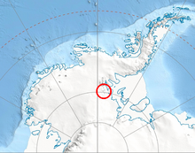
Mount McClintock is the highest mountain in the Britannia Range in Antarctica, surmounting the south end of Forbes Ridge, 6 nautical miles east of Mount Olympus.
Young Glacier is a glacier which flows from Mount Gozur and Ichera Peak in Maglenik Heights eastwards for 8 miles (13 km) and terminates at the north end of Barnes Ridge on the east side of Sentinel Range, Ellsworth Mountains in Antarctica. It was first mapped by the United States Geological Survey (USGS) from surveys and U.S. Navy air photos from 1957–59. It was named by the Advisory Committee on Antarctic Names (US-ACAN) for First Lieutenant Dale L. Young of the United States Air Force (USAF), who participated in establishing the South Pole Station in the 1956–57 season.
Mount Aldrich is a massive, somewhat flat-topped mountain standing at the east side of Ragotzkie Glacier in the Britannia Range, Antarctica.
The Anderson Massif is a prominent ice-covered massif about 10 nautical miles (20 km) across and rising to a height of 2,190 metres (7,190 ft), located at the junction of Splettstoesser Glacier and Minnesota Glacier in the Heritage Range of the Ellsworth Mountains, Antarctica. It was named by the Advisory Committee on Antarctic Names for John J. Anderson, a geologist who was field leader of the University of Minnesota Ellsworth Mountains Party, 1961–62.

Balish Glacier is a glacier, 18 nautical miles (33 km) long, flowing north from the Soholt Peaks to enter Splettstoesser Glacier just northeast of Springer Peak, in the Heritage Range, Ellsworth Mountains. It was mapped by the United States Geological Survey from surveys and from U.S. Navy air photos, 1961–66, and was named by the Advisory Committee on Antarctic Names for Commander Daniel Balish, Executive Officer of U.S. Navy Squadron VX-6 during Operation Deep Freeze 1965, and Commanding Officer in 1967.
Bowers Corner is a peak located 9 nautical miles (17 km) southeast of Lishness Peak in Owen Ridge, the extreme south end of the main ridge of Sentinel Range in Ellsworth Mountains. The feature stands at the eastern side of the terminus of Nimitz Glacier where it bends, or makes a corner, on joining Minnesota Glacier. It was first mapped by the United States Geological Survey from surveys and from U.S. Navy air photos, 1957–59, and named by the Advisory Committee on Antarctic Names for Lieutenant Richard A. Bowers, U.S. Navy Reserve, who was in charge of the construction crew which built the IGY South Pole Station in the 1956–57 season.
Grimes Glacier is a steep glacier descending from the east side of Anderson Massif, in the Heritage Range of the Ellsworth Mountains of Antarctica. It was mapped by the United States Geological Survey from surveys and U.S. Navy air photos, 1961–66, and was named by the Advisory Committee on Antarctic Names for Master Chief Equipmentman Paul D. Grimes, U.S. Navy, who supervised the construction crews during relocation of Williams Air Field at McMurdo Sound in the closing month of U.S. Navy Operation Deep Freeze 1965.
Pioneer Heights is a group name in the Heritage Range, Ellsworth Mountains, encompassing the large area of hills, ridges and peaks located eastward of Schneider and Schanz Glaciers and between Splettstoesser and Union Glaciers. Among these features are the Inferno Ridge, the Nimbus Hills, Gross, Buchanan and Collier Hills. The Pioneer Heights were mapped by the United States Geological Survey (USGS) from ground surveys and U.S. Navy air photos from 1961 to 1966. The name was applied by the Advisory Committee on Antarctic Names (US-ACAN) in association with the name Heritage Range.
Dunbar Ridge is a narrow ridge in Antarctica, 10 nautical miles (18 km) long, which separates the upper reaches of Balish Glacier and Schneider Glacier in the Heritage Range. It was named by the University of Minnesota Geological Party, 1963–64, for Warrant Officer William Dunbar, maintenance officer of the 62nd Transportation Detachment, who aided the party.
Fendorf Glacier is a broad glacier draining from the eastern slopes of the Gifford Peaks and flowing north to merge with Dobbratz Glacier, in the Heritage Range of the Ellsworth Mountains, Antarctica. It was mapped by the United States Geological Survey from ground surveys and U.S. Navy air photos, 1961–66, and was named by the Advisory Committee on Antarctic Names for Lieutenant Commander James E. Fendorf, U.S. Navy, a pilot with Squadron VX-6 during Operation Deep Freeze 1966.
The Meteorite Hills are a group of hills, 11 nautical miles long, forming the western portion of the Darwin Mountains in Antarctica. The hills are located between the heads of Darwin Glacier and Hatherton Glacier.
Hall Peak is a peak, 2,170 metres (7,120 ft) high, in the Heritage Range of Antarctica, surmounting the dividing ridge at the upper reaches of Rennell Glacier, Schmidt Glacier and Larson Valley. It was named by the University of Minnesota Geological Party to these mountains in 1963–64 for Walter D. M. (Mike) Hall, a geologist with the party.
Schneider Glacier is a glacier in the Heritage Range in Antarctica. It is 15 nautical miles long, draining north between the Dunbar and Inferno Ridge and coalescing with Balish Glacier before entering the Splettstoesser Glacier. It was mapped by United States Geological Survey (USGS) from surveys and U.S. Navy air photos, 1961–66. It was named by Advisory Committee on Antarctic Names (US-ACAN) for Commander Arthur F. Schneider, Maintenance Officer of U.S. Navy Squadron VX-6 during Deep Freeze 1965, and Commanding Officer in 1968.
Rennell Glacier is a glacier, 10 nautical miles long, in the Pioneer Heights, Heritage Range. It drains northwest, to the east of Inferno Ridge, to join Splettstoesser Glacier. Named by the University of Minnesota Geological Party to these mountains, 1963–64, for K.P. Rennell, biologist with the party.
Robinson Peak is a sharp peak on the ridge east of Rennell Glacier, standing 7 nautical miles (13 km) south of Mount Virginia in the Heritage Range. It was mapped by the United States Geological Survey (USGS) from surveys and U.S. Navy air photos, 1961–66, and was named by the Advisory Committee on Antarctic Names (US-ACAN) for Willard E. Robinson, a construction mechanic at Byrd Station in 1965. Robinson Peak was first successfully climbed on January 2–3, 2013 by Pachi Ibarra, Ralf Laier and Todd Passey.