Inhaca Island

Last updated
Inhaca Island
Native name:
Ilha da Inhaca
The Crocodile River traverses South Africa ESA418736, Inhaca.jpg
Inhaca Island, location.png
Location in southern Mozambique
Geography
LocationIndian Ocean
Adjacent bodies of waterMaputo Bay
Area52 km2 (20 sq mi)
Length12 km (7.5 mi)
Width7 km (4.3 mi)
Highest elevation104 m (341 ft)
Highest pointMount Inhaca
Administration
Mozambique
MunicipalityMaputo

Inhaca Island (Portuguese: Ilha da Inhaca) is a subtropical island of Mozambique off the East African coast. The main village is Inhaca, situated just over a kilometer from Inhaca Airport. Various tourist lodges are situated along the northwestern coastline. The island is flanked by protected areas along the western and eastern coastlines, while the majority of the population lives in the interior.

Contents

The 52 km2 (20 sq mi) island separates Maputo Bay (Baía de Maputo) to the west from the Indian Ocean off its eastern shores. The island's irregular coastline approaches the mainland Machangulo peninsula at Ponta Torres where a 500-metre-wide (1,600 ft) tidal race separates the two headlands. In administrative terms Inhaca is a municipal district of the municipality of Maputo, while the Machangulo peninsula is included under the Lubombo Transfrontier Conservation Area and is part of the district of Matutuíne, Maputo Province.

Geographical features

The island's dimensions are approximately 12 km (n-s) by 7 km (e-w). The highest point above sea level is the 104-metre (341 ft) Mount Inhaca on the north-eastern shoreline. The south-western peninsula is known as Ponta Punduine while Ponta Torres to the south-east approaches the mainland. Two inland swamps occur at the northerly airstrip and southern Nhaquene respectively. Besides Inhaca settlement on the western shore there are five smaller villages including Inguane, Nhaquene, Ridjeni and Tobia.

History

Despite being a part of the Portuguese Mozambique until 1975, the island of Inhaca, so close to the harbour of Maputo, was occupied by the British from 1823 until the MacMahon Treaty of 24 July 1875. The British used the island (amongst many others all around Africa) to patrol and control the slave traffic in the region. [1]

Ecology

Flora

Monte Inhaca is a forested dune on the northeastern shoreline that reaches 104 m in altitude. Monte Inhaca.jpg
Monte Inhaca is a forested dune on the northeastern shoreline that reaches 104 m in altitude.

The island is a regular destination for ecotourists and ecological researchers. The central land area consists of cultivated fields, while grassy plains are found to the north, flanked by protected usnea-covered dune forests along the eastern and western shores. Extensive exposed mudflats fringe the western and southern shores at low tide. Mangroves cover large sections of the northern shores and southern Saco Bay.

The sub-tropical evergreen forest on the island includes the following tree species: Sideroxylon inerme , Apodytes dimidiata , Euclea schimperi , Manilkara discolor , Dovyalis rhamnoides , Dovyalis tristis , Diospyros natalensis , Clausena anisata , Cassine papillosa , Olea africana , Ficus burtt-davyi , Ficus sansibarica , Ficus capensis , Commiphora neglecta , Commiphora schlechteri , Allophylus melanocarpus , Erythroxylon emarginatum , Vepris undulata , Deinbollia oblongifolia , Scolopia ecklonii , Thespesia populnea and Galpinia transvaalica .

Fauna

Among 160 coral species are staghorn and plate corals. There are two badly damaged pure coral reefs flanking the island's western perimeters, in very shallow water, which are supposed to be protected but in reality there is no actual control of the marine reserves.

Conspicuous fish are king mackerel - called serra, besides potato bass, barracuda and giant trevally. Others present are brindle bass/giant grouper, scorpionfish, butterflyfish, pufferfish, parrotfish, moray eel, Inhaca fringelip and seahorses. Whale sharks and manta rays visit in summer.

Cetaceans

Although humpback whales migrate seasonally past these shores, whale watching has never become a popular attraction here. The ocean is generally too rough and the whales too far out, while the hiring boats are too expensive for the average person. Southern right whales have become rare today, [2] though whales were historically abundant [3] before they were wiped out by commercial and illegal hunts, including mass illegal hunts by the Soviet Union and Japan during the 1960s and 1970s.

Resident populations of the Indo-Pacific humpbacked dolphin and the Indian Ocean bottlenose dolphin occur in the waters around the island. The bottlenose dolphin's abundance fluctuates seasonally, increasing during the austral winter. The humpback dolphin is more sedentary, living in extremely shallow inshore areas of the western and southern coasts, and form larger groups (11-14 dolphins) than recorded elsewhere in southern Africa. Bottlenose dolphins frequent the waters of the northwestern coast, and their group size varies largely from individuals and pairs to hundreds of dolphins. [4]

Other mammals and reptiles

A very small, remaining population of dugong also occur here. [5] [6] Two species of sea turtles (loggerheads and critically endangered leatherbacks) visit the eastern shores in summer to breed.

Birds

Inhaca is home to about 300 bird species, both resident and migratory. Species of conservation concern are the pink-backed pelican, lesser crested tern, crab plover, greater sand plover, Mongolian plover, Terek sandpiper, southern banded snake eagle, mangrove kingfisher, grey-rumped swallow and spotted ground thrush. The snake eagle, ground thrush and mangrove kingfisher are specials of the southeasterly coastal regions, besides Rudd's apalis, Neergaard's sunbird and pink-throated twinspot which are also present. The southerly Nhaquene Swamp and Saco Bay are strongholds for the sooty falcon, while Eleonora's falcon is a rare vagrant. Terns roost on the northerly Portuguese Island 25°58′31″S32°54′38″E / 25.97528°S 32.91056°E / -25.97528; 32.91056 (Portuguese Island) and house crows established themselves during the 1970s.

Gazetteer of landmarks and villages

Map all coordinates using: OpenStreetMap  
Download coordinates as: KML

Related Research Articles

Whale watching Viewing cetaceans in their habitats

Whale watching is the practice of observing whales and dolphins (cetaceans) in their natural habitat. Whale watching is mostly a recreational activity, but it can also serve scientific and/or educational purposes. A study prepared for International Fund for Animal Welfare in 2009 estimated that 13 million people went whale watching globally in 2008. Whale watching generates $2.1 billion per annum in tourism revenue worldwide, employing around 13,000 workers. The size and rapid growth of the industry has led to complex and continuing debates with the whaling industry about the best use of whales as a natural resource.

Cetacean surfacing behaviour

Cetacean surfacing behaviour or breaching is a group of behaviours demonstrated by the Cetacea infraorder when they come to the water's surface to breathe. Time intervals between surfacing can vary depending on the species, surfacing style or the purpose of the dive; some species have been known to dive for up to 85 minutes at a time when hunting, and dives in excess of three hours have been observed in Cuvier's beaked whale under extreme circumstances.

Maputo Bay Body of water

Maputo Bay, formerly also known as Delagoa Bay from Baía da Lagoa in Portuguese, is an inlet of the Indian Ocean on the coast of Mozambique, between 25° 40' and 26° 20' S, with a length from north to south of over 90 km long and 32 km wide.

Bazaruto Archipelago


The Bazaruto Archipelago is a group of six islands in Mozambique, near the mainland city of Vilankulo. It comprises the islands of Bazaruto, Benguerra, Magaruque, Banque, Santa Carolina and Shell. Nyati Island is located further south.

Marine National Park, Gulf of Kutch National park in Gujarat, India.

Marine National Park in the Gulf of Kutch is situated on the southern shore of the Gulf of Kutch in the Devbhumi Dwarka district of Gujarat state, India. In 1980, an area of 270 km2 from Okha to Jodiya was declared Marine Sanctuary. Later, in 1982, a core area of 110 km2 was declared Marine National Park under the provisions of the Wildlife (protection) Act, 1972 of India. There are 42 islands on the Jamnagar coast in the Marine National Park, most of them surrounded by reefs. The best-known island is Pirotan.

Inhaca Place in Maputo Province, Mozambique

Inhaca is a settlement in Mozambique, on the subtropical Inhaca Island off the East African coast. Inhaca settlement is centered on a mission station located about 32 km east of Maputo.

Mnazi Bay-Ruvuma Estuary Marine Park A marine park in Tanzania

The Mnazi Bay-Ruvuma Estuary Marine Park(MBREMP) was established on 1 July 2000 under Act No. 29 of 1994 of Marine Parks and Reserves of Tanzania.

Maputo Protection Area

Maputo Protection Area is a marine protected area in Mozambique. It was established when the government of Mozambique proclaimed the area on the 14 July 2009 and declared the 678 square kilometres (262 sq mi) Marine Protected Area stretching from Ponta do Ouro in the south to the Maputo River Mouth in Maputo Bay in the north as a Marine Protected Area, the area stretches three nautical miles into sea.

Bazaruto Archipelago National Park Marine and terrestrial protected area in the Bazaruto Archipelago in Mozambique

The Bazaruto Archipelago National Park (BANP) is a protected area in the Inhambane Province of Mozambique on the Bazaruto Archipelago. The park was proclaimed on 25 May 1971. It is off the coast of the Vilanculos and Inhassoro districts, covering a large expanse of ocean and six islands.

Mohéli National Park

Mohéli National Park is a national park in the Comoros. It includes marine, coastal, and terrestrial areas on and around the island of Mohéli. The park has an area of 643.62 km2. Established as Mohéli Marine Park on 19 April 2001, it was first protected area in the Comoros. It was redesignated a national park in 2010. In 2015 the park was expanded to include about three-quarters of Mohéli's terrestrial area.

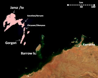
Thevenard Island is located approximately 22 kilometres (14 mi) off the coast of Onslow in the Pilbara region of Western Australia.

Delagoa Marine ecoregion on the eastern coast of southern Africa

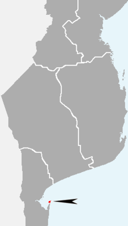
Delagoa is a marine ecoregion along the eastern coast of Africa. It extends along the coast of Mozambique and South Africa from the Bazaruto Archipelago to Lake St. Lucia in South Africa in South Africa's Kwazulu-Natal province. It adjoins the Bight of Sofala/Swamp Coast ecoregion to the north, and the Natal ecoregion to the south. It has Africa's southernmost tropical coral reefs and mangrove forests. It is the southernmost Indo-Pacific ecoregion, marking the transition from the tropical Indo-Pacific to Temperate Southern Africa.

Montebello Islands Marine Park Australian marine park

The Montebello Island Marine Park is located off the northwest coast of Western Australia, about 1,600 km north of Perth, and 120 km west of Dampier. The reserve includes the entire group of Montebello Islands.

References

  1. Para a História da Aliança Luso Britânica, by José be Almada, Imprensa Nacional de Lisboa, 1955, pp. 60-61
  2. Banks A., Best P., Gullan A., Guissamulo A., Cockcroft V., Findlay K. (2010). "Recent Sightings of Southern Right Whales in Mozambique" (PDF). Retrieved 18 December 2014.{{cite journal}}: Cite journal requires |journal= (help)CS1 maint: multiple names: authors list (link)
  3. Richards R.. 2009. Past and present distributions of southern right whales (Eubalaena australis), New Zealand Journal of Zoology, Vol. 36: 447-459. 1175-8821 (online); 0301-4223 (print)/09/3604–0447. The Royal Society of New Zealand. Retrieved on December 18. 2014
  4. Bandeira O. S., Silva E. P. R., Paula J., Macia A., Hernroth L., Guissamulo T. A., Gove Z. D. Marine biological research in Mozambique: past, present and future. University of Eduardo Mondlane on ResearchGate. Retrieved on December 18, 2014
  5. UNESCO. Assessing potential World Heritage marine sites in the Western Indian Ocean - Marine mammals – Dugong, Whales and Dolphins. Retrieved on December 18. 2014
  6. http://www.DUGONGS.ORG. SAVING ENDANGERED DUGONGS OF THE WESTERN INDIAN OCEAN Archived 2015-02-15 at the Wayback Machine . Retrieved on December 18. 2014

Coordinates: 26°01′S32°57′E / 26.017°S 32.950°E / -26.017; 32.950