
Cercado is a province in the northeastern parts of the Bolivian department of Oruro. Its capital is Oruro. The hamlet of Paria, established in 1535, was the first Spanish settlement in Bolivia and previously had been a regional capital of the Inca Empire. Paria is located in Soracachi municipality.
Inka Wasi or Inkawasi may refer to:

Sipe Sipe Municipality is the second municipal section of the Quillacollo Province in the Cochabamba Department, Bolivia. Its seat is Sipe Sipe. At the time of census 2001 the municipality had 31,337 inhabitants.
Ichoca Municipality is the fifth municipal section of the Inquisivi Province in the La Paz Department, Bolivia. Its seat is Ichoca.
Inkachaka Dam is a dam in Bolivia situated in the La Paz Department, Pedro Domingo Murillo Province, La Paz Municipality, north east of La Paz.
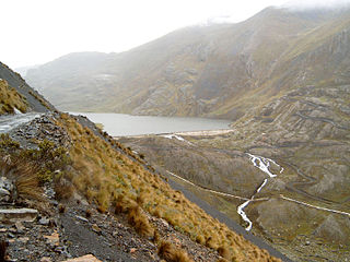
Waña Quta is a lake in Bolivia in the La Paz Department, Inquisivi Province, Ichoca Municipality, Ichoca Canton. It lies south east of the Kimsa Cruz mountain range, the village and the mountain Waña Quta. The lake is about 0.5 km long and 0.4 km at its widest point and situated at a height of about 4,761 metres (15,620 ft).
Laqaya is an archaeological site in the Altiplano of Bolivia. It is situated in the Potosí Department, Nor Lípez Province, Colcha "K" Municipality. The site was declared a National Archaeological Monument by Supreme Decrete 27607 on July 2, 2004.

Inka is a mountain in the Cordillera Real in the Bolivian Andes. It is situated in the La Paz Department, Sud Yungas Province, Yanacachi Municipality. Inka lies north-east of the mountain Mururata and south-east of the mountain Wanakuni.
Jach'a Q'awa is a 4,718-metre-high (15,479 ft) mountain in the Cordillera de los Frailes in the Andes of Bolivia. It is situated in the Potosí Department, Tomás Frías Province, Tinguipaya Municipality, north of the Pillku Mayu. It lies southeast of the village of Janq'u Laqaya (Jankho Lacaya) and the mountain named Janq'u Laqaya (Jhanco Lacaya) and northwest of Pari Chata.
Inka Pukara is a 4,444-metre-high (14,580 ft) mountain in the Andes of Bolivia. It is located in the Oruro Department, Pantaleón Dalence Province, Huanuni Municipality. Inka Pukara lies southeast of Huanuni. The village of Pukara (Pucara) lies at its feet.
Kunturiri is a 4,526-metre-high (14,849 ft) mountain in the Bolivian Andes. It is situated west of Potosí in the Potosí Department, Tomás Frías Province, Yocalla Municipality. Kunturiri lies north-west of the lower mountain Inka Qhata.
Laqaya is a 4,825-metre-high (15,830 ft) mountain in the Chilla-Kimsa Chata mountain range in the Andes of Bolivia. It is situated in the La Paz Department, Ingavi Province, at the border of the Jesús de Machaca Municipality and the Tiwanaku Municipality.
Jach'a Jawira which later is named Q'ara Qullu and Waña Jawira is a Bolivian river in the La Paz Department and in the Oruro Department. Its waters flow towards Uru Uru Lake.
Inka Pukara is a mountain in the Bolivian Andes which reaches a height of approximately 4,400 m (14,400 ft). It is located in the La Paz Department, Aroma Province, Patacamaya Municipality, northeast of Patacamaya.
Inka Laqaya is a mountain in the Bolivian Andes which reaches a height of approximately 3,280 m (10,760 ft). It is located in the Cochabamba Department, Quillacollo Province, Sipe Sipe Municipality, southwest of Sipe Sipe.
Wisk'achani is a 3,611-metre-high (11,847 ft) mountain in the Bolivian Andes. It is located in the Cochabamba Department, Quillacollo Province, Sipe Sipe Municipality. Wisk'achani lies northwest of Inka Laqaya.
Inka Pukara is a 4,422-metre-high (14,508 ft) mountain in the Bolivian Andes. It is located in the Cochabamba Department, Arque Province, Tacopaya Municipality, southeast of Tacopaya.
Inka Pukara may refer to:
Inka P'iqi is a 4,110-metre-high (13,480 ft) mountain in the Bolivian Andes. It is located in the Cochabamba Department, on the border of the Arani Province, Vacas Municipality, and the Mizque Province, Alalay Municipality. Inka P'iqi lies southwest of Jatun Llallawa and south of Juch'uy Llallawa.
Janq'u Laqaya is a mountain in the Andes of Bolivia which reaches a height of approximately 4,300 m (14,100 ft). It is located in the Oruro Department, Sajama Province, Curahuara de Carangas Municipality, south of Ch'apiri.


