Kreuzberg is a district of Berlin, Germany. It is part of the Friedrichshain-Kreuzberg borough located south of Mitte. During the Cold War era, it was one of the poorest areas of West Berlin, but since German reunification in 1990, it has become more gentrified and is known for its arts scene.

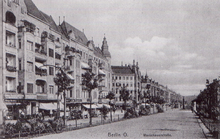
Wedding is a locality in the borough of Mitte, Berlin, Germany. It was a separate borough in the north-western inner city until it was fused with Tiergarten and Mitte in Berlin's 2001 administrative reform. At the same time the eastern half of the former borough of Wedding—on the other side of Reinickendorfer Straß

Mitte is the first and most central borough of Berlin. The borough consists of six sub-entities: Mitte proper, Gesundbrunnen, Hansaviertel, Moabit, Tiergarten and Wedding.

Pankow is the second largest area of Berlin by population. In Berlin's 2001 administrative reform, it was merged with the former boroughs of Prenzlauer Berg and Weißensee; the resulting borough retained the name Pankow. Pankow was sometimes claimed by the Western Allies to be the capital of the German Democratic Republic, while the German Democratic Republic itself considered East Berlin to be its capital.

Moabit is an inner city locality in the borough of Mitte, Berlin, Germany. As of 2022, about 84,000 people lived in Moabit. First inhabited in 1685 and incorporated into Berlin in 1861, the former industrial and working-class neighbourhood is fully surrounded by three watercourses, which define its present-day border. Between 1945 and 1990, Moabit was part of the British sector of West Berlin and directly bordered East Berlin.
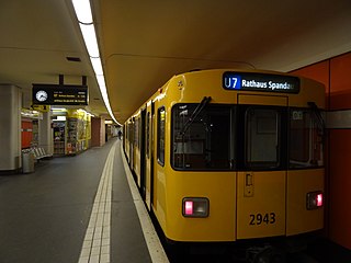
The U7 is a rail line on the Berlin U-Bahn. It runs completely underground for a length of 31.8 kilometres (19.8 mi) through 40 stations and connects Spandau, via Neukölln, to Gropiusstadt and Rudow. The U7 was originally the south-eastern branch of the Nord-Süd-Bahn (U6) that ran between the branching point at Belle-Alliance-Straße (Mehringdamm) and Grenzallee; however, in the 1960s, this stretch was separated from the rest of the line and extended at each end to form a new line.

Friedrichshain is a quarter (Ortsteil) of the borough of Friedrichshain-Kreuzberg in Berlin, Germany. From its creation in 1920 until 2001, it was a freestanding city borough. Formerly part of East Berlin, it is adjacent to Mitte, Prenzlauer Berg, Kreuzberg and Lichtenberg.

Bernauer Straße is a street of Berlin situated between the localities of Gesundbrunnen and Mitte, today both belonging to the Mitte borough. It runs from the Mauerpark at the corner of Prenzlauer Berg to the Nordbahnhof. The street's name refers to the town of Bernau bei Berlin, situated in Brandenburg.
The Oberbaum Bridge is a double-deck bridge crossing Berlin, Germany's River Spree, considered one of the city's landmarks. It links Friedrichshain and Kreuzberg, former boroughs that were divided by the Berlin Wall, and has become an important symbol of Berlin's unity.

The Berlin border crossings were border crossings created as a result of the post-World War II division of Germany. Prior to the construction of the Berlin Wall in 1961, travel between the Eastern and Western sectors of Berlin was completely uncontrolled, although restrictions were increasingly introduced by the Soviet and East German authorities at major crossings between the sectors. This free access, especially after the closure of the Inner German border, allowed the Eastern Bloc emigration and defection to occur. East German officials, humiliated by this mass defection, subsequently chose to erect the Berlin Wall in order to prevent residents from leaving East Germany.

Naturkundemuseum, formerly Zinnowitzer Straße, is a Berlin U-Bahn station located on the U6 in the district Mitte.
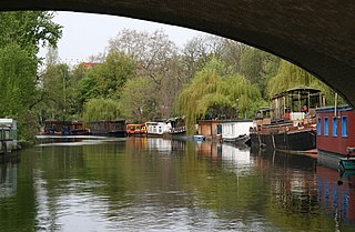
The Landwehr Canal, is a 10.7-kilometre-long (6.6 mi) canal parallel to the Spree river in Berlin, Germany, built between 1845 and 1850 to plans by Peter Joseph Lenné. It connects the upper part of the Spree at the eastern harbour in Friedrichshain with its lower part in Charlottenburg, flowing through Kreuzberg and Tiergarten.

Mitte is a central section of Berlin, Germany, in the eponymous borough of Mitte. Until 2001, it was itself an autonomous district.

Gesundbrunnen is a locality (Ortsteil) of Berlin in the borough (Bezirk) of Mitte. It was created as a separate entity during the 2001 administrative reform, formerly the eastern half of the former Wedding district and locality. Gesundbrunnen has the highest percentage of non-German residents of any Berlin locality, at 35.1% as of the end of 2008.

The Berlin Customs Wall was a ring wall around the historic city of Berlin, between 1737 and 1860; the wall itself had no defence function but was used to facilitate the levying of taxes on the import and export of goods (tariffs), which was the primary income of many cities at the time.
Oranienburger Vorstadt is a historic district of Berlin in what is now the northwestern part of Mitte and the adjacent Gesundbrunnen area, in the modern Mitte borough.

Berlin is recognized as a world city of culture and creative industries. Numerous cultural institutions, many of which enjoy international reputation are representing the diverse heritage of the city. Many young people, cultural entrepreneurs and international artists continue to settle in the city. Berlin has established itself as a popular nightlife and entertainment center in Europe.
The Ackerstraße is a street in Berlin which runs northwest from near the Liesenstraße – Scheringstraße traffic circle in Gesundbrunnen to Invalidenstraße, where it turns south, terminating at the Linienstraße in Mitte.

The Mehringdamm is a street in southern Kreuzberg, Berlin. In the north it starts at Mehringbrücke and ends - with its southernmost houses already belonging to Tempelhof locality - on Platz der Luftbrücke. It is the historical southbound Berlin-Halle highway, now forming the federal route 96. The main junction of Mehringdamm is with the 19th-century ring road around Berlin's inner city, named Yorckstraße west, and Gneisenaustraße east of Mehringdamm.