Innfjorden

Last updated
Innfjorden
Village
Norway More og Romsdal location map.svg
Red pog.svg
Innfjorden
Location in Møre og Romsdal
Norway location map.svg
Red pog.svg
Innfjorden
Innfjorden (Norway)
Coordinates: 62°29′36″N07°33′35″E / 62.49333°N 7.55972°E / 62.49333; 7.55972 Coordinates: 62°29′36″N07°33′35″E / 62.49333°N 7.55972°E / 62.49333; 7.55972
Country Norway
Region Western Norway
County Møre og Romsdal
District Romsdal
Municipality Rauma Municipality
Area [1]
  Total 0.32 km2 (0.12 sq mi)
Elevation [2] 30 m (100 ft)
Population (2016) [1]
  Total 288
  Density 900/km2 (2,000/sq mi)
Time zone CET (UTC+01:00)
  Summer (DST) CEST (UTC+02:00)
Post Code6315 Innfjorden

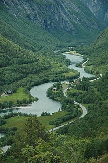
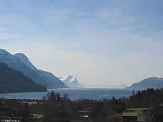
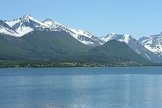
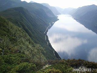
Innfjorden is a village in Rauma Municipality in Møre og Romsdal county, Norway. It is situated about 10 kilometres (6.2 mi) southwest of the town of Åndalsnes and 9 kilometres (5.6 mi) southeast of the village of Måndalen along the European Route E136 highway. The road from Åndalsnes to Innfjorden goes through the 6,594-metre (21,634 ft) long Innfjord Tunnel, which opened in 1991 after a series of deaths caused by avalanches on the former road along the shore of Romsdal Fjord.

Møre og Romsdal County (fylke) of Norway

Møre og RomsdalUrban East Norwegian: [²møːrə ɔ ˈrʊmsdɑːl](listen) is a county in the northernmost part of Western Norway. It borders the counties of Trøndelag, Oppland, and Sogn og Fjordane. The county administration is located in the town of Molde, while Ålesund is the largest town. The county is governed by the Møre og Romsdal County Municipality which includes an elected county council and a county mayor. The national government is represented by the county governor.

Norway constitutional monarchy in Northern Europe

Norway, officially the Kingdom of Norway, is a Nordic country in Northwestern Europe whose territory comprises the western and northernmost portion of the Scandinavian Peninsula; the remote island of Jan Mayen and the archipelago of Svalbard are also part of the Kingdom of Norway. The Antarctic Peter I Island and the sub-Antarctic Bouvet Island are dependent territories and thus not considered part of the kingdom. Norway also lays claim to a section of Antarctica known as Queen Maud Land.

Åndalsnes Town in Western Norway, Norway

Åndalsnes  is a town in Rauma Municipality in Møre og Romsdal county, Norway. Åndalsnes is the administrative center of Rauma Municipality. The 2.22-square-kilometre (550-acre) town has a population (2013) of 2,244, giving it a population density of 1,011 inhabitants per square kilometre (2,620/sq mi). The village of Isfjorden lies about 7 kilometres (4.3 mi) to the east, Veblungsnes lies just to the west across the Rauma River, and Innfjorden lies about 10 kilometres (6.2 mi) to the southwest via the European Route E136 highway.

The 0.32-square-kilometre (79-acre) village has a population (2016) of 288 which gives the village a population density of 900 inhabitants per square kilometre (2,300/sq mi). [1] The local economy is mainly based on agriculture, while there is some industry and a few service companies relating to tourism, transportation, and road safety. In addition there is an elementary school, kindergarten, and the small Innfjorden Chapel.

Population density A measurement of population numbers per unit area or volume

Population density is a measurement of population per unit area or unit volume; it is a quantity of type number density. It is frequently applied to living organisms, and most of the time to humans. It is a key geographical term. In simple terms population density refers to the number of people living in an area per kilometer square.

Agriculture Cultivation of plants and animals to provide useful products

Agriculture is the science and art of cultivating plants and livestock. Agriculture was the key development in the rise of sedentary human civilization, whereby farming of domesticated species created food surpluses that enabled people to live in cities. The history of agriculture began thousands of years ago. After gathering wild grains beginning at least 105,000 years ago, nascent farmers began to plant them around 11,500 years ago. Pigs, sheep and cattle were domesticated over 10,000 years ago. Plants were independently cultivated in at least 11 regions of the world. Industrial agriculture based on large-scale monoculture in the twentieth century came to dominate agricultural output, though about 2 billion people still depended on subsistence agriculture into the twenty-first.

Tourism travel for recreational or leisure purposes

Tourism is travel for pleasure or business; also the theory and practice of touring, the business of attracting, accommodating, and entertaining tourists, and the business of operating tours. Tourism may be international, or within the traveller's country. The World Tourism Organization defines tourism more generally, in terms which go "beyond the common perception of tourism as being limited to holiday activity only", as people "traveling to and staying in places outside their usual environment for not more than one consecutive year for leisure and not less than 24 hours, business and other purposes".

Surrounding Innfjorden are 1,200-to-1,800-metre (3,900 to 5,900 ft) tall peaks on the east, south, and west sides with Romsdal Fjord to the north. The area is frequented by mountain hikers and lately a lot of BASE jumpers have discovered the mountains around Innfjorden.

BASE jumping activity where participants jump from fixed objects and use a parachute to break their fall

BASE jumping, also sometimes written as B.A.S.E. jumping, is parachuting or wingsuit flying from a fixed structure or cliff. "BASE" is an acronym that stands for four categories of fixed objects from which one can jump: building, antenna, span, and earth (cliff). Due to the lower altitudes of the jumps, BASE jumping is significantly more dangerous than skydiving from a plane. In the U.S., BASE jumping is currently regarded by many as a fringe extreme sport or stunt.

Related Research Articles

Surnadal Municipality in Møre og Romsdal, Norway

Surnadal  is a municipality in Møre og Romsdal county, Norway. It is part of the Nordmøre region. The administrative centre is the village of Skei. Other villages in Surnadal include Glærem, Mo, Stangvik, Surnadalsøra, Sylte, Todalsøra, and Åsskard.

Ørsta Municipality in Møre og Romsdal, Norway

Ørsta  is a municipality in Møre og Romsdal county, Norway. It is part of the Sunnmøre region of Western Norway. The administrative centre of the municipality is the village of Ørsta. Other villages in the municipality include Hovdebygda, Flåskjer, Leira, Liadal, Urke, Bjørke, Barstadvik, Åmdalen, Follestaddalen, Nordre Vartdal, Vartdal, Sæbø, Sætre, Store-Standal, and Ytre Standal.

Stranda Municipality in Møre og Romsdal, Norway

Stranda is a municipality in Møre og Romsdal county, Norway. It is part of the Sunnmøre region. The administrative centre of the municipality is the village of Stranda. Stranda consists of three smaller villages and one larger central village. The smaller villages are Hellesylt, Geiranger, and Liabygda. The central village, Stranda, has about 2,600 inhabitants. There is also the small village of Helsem which is located just south of the village of Stranda. Stranda Municipality is also known for tourist attractions like the Geirangerfjorden and Sunnylvsfjorden.

Rauma, Norway Municipality in Møre og Romsdal, Norway

Rauma is a municipality in Møre og Romsdal county, Norway. It is part of the traditional district of Romsdal. The administrative centre is the town of Åndalsnes. Other settlements in Rauma include the villages of Vågstranda, Måndalen, Innfjorden, Veblungsnes, Verma, Isfjorden, Eidsbygda, Rødven, Åfarnes, and Mittet. Most settlement in the municipality is located along the fjords and in the Romsdalen valley.

Nesset Municipality in Møre og Romsdal, Norway

Nesset is a municipality in Møre og Romsdal county, Norway on the Romsdal Peninsula. The administrative centre is the village of Eidsvåg. Other population centers include Rausand, Boggestranda, Myklebostad, Eresfjord, and Eikesdalen.

Stryn Municipality in Sogn og Fjordane, Norway

Stryn is a municipality in the county of Sogn og Fjordane, Norway. It is located in the traditional district of Nordfjord. The administrative center of the municipality is the village of Stryn. The municipality is located along the innermost part of the Nordfjorden. Some of the main villages in Stryn include Loen, Innvik, Utvik, Randabygda, Olden, and Flo.

Rauma (river) river in Norway

The Rauma is a river that runs through Romsdalen, a valley in Møre og Romsdal and Oppland counties in Norway. It runs for 68 kilometres (42 mi) from Lesjaskogsvatnet, a lake in the municipality of Lesja, to the town of Åndalsnes in the municipality of Rauma. The river was once famous for its salmon-fishing, but since an infection with Gyrodactylus salaris only 5 to 10% of the original stock survives. The salmon runs up to the Slettafossen, a 16-metre (52 ft) high combination of waterfalls and rapids more than 42 kilometres (26 mi) upriver from the estuary.

Lysefjord fjord in Forsand, Norway

Lysefjord or Lysefjorden is a fjord located in the Ryfylke area in southwestern Norway. The 42-kilometre (26 mi) long fjord lies in Forsand municipality in Rogaland county, about 25 kilometres (16 mi) east of the city of Stavanger. The name means light fjord, and is said to be derived from the lightly coloured granite rocks along its sides. It is particularly well known by the huge Preikestolen cliff overlooking the fjord, which is a major tourist destination for the region. The fairly isolated village of Lysebotn lies at the eastern end of the fjord and the villages of Forsand and Oanes both lie at the western end of the fjord near the Lysefjord Bridge, the only crossing of the fjord.

Ofoten Traditional district in Northern Norway, Norway

Ofoten is a traditional district in Nordland county in Northern Norway. It consists of the municipalities of Tysfjord, Ballangen, Evenes, Tjeldsund, Narvik, and Lødingen. It is named after the main fjord, Ofotfjorden, which is at the center of this district. The 7,829-square-kilometre (3,023 sq mi) district was home to 29,968 residents in 2016, with almost half of the residents living in the town of Narvik.

Sunndalsøra Village in Western Norway, Norway

Sunndalsøra  is a town and the administrative centre of Sunndal Municipality in Møre og Romsdal county, Norway.

Romsdalsfjord fjord in Norway

Romsdalsfjord or Romsdal Fjord is the ninth-longest fjord in Norway. It is 88 kilometres (55 mi) long and located in the Romsdal district of Møre og Romsdal county. It flows through the municipalities of Midsund, Haram, Vestnes, Molde, Nesset, and Rauma. The deepest point in the fjord is just southwest of the town of Molde, where it is 550 metres (1,800 ft) deep. Romsdalsfjord is a threshold-fjord, as it is separated from the ocean by shallower areas at the mouth. Several islands and skerries also shelter the wide central fjord from the Atlantic.

Storfjorden (Sunnmøre) fjord in Sunnmøre, Norway

Storfjorden or Storfjord is a 110-kilometre (68 mi) long fjord in the Sunnmøre region of Møre og Romsdal county, Norway. It stretches from the village of Hareid in the west to the villages of Tafjord and Geiranger in the east. The Storfjorden system branches off into several smaller fjords including the famous Geirangerfjord and Tafjorden. At the village of Stranda, the main fjord branches off into the Sunnylvsfjorden-Geirangerfjorden to the west and the Norddalsfjorden-Tafjorden to the east.

Norwegian County Road 63 road in Norway

Norwegian County Road 63 is a Norwegian county road in Møre og Romsdal county and a very small part in Oppland county, Norway. It begins at Norwegian National Road 15 along the lake Langvatnet in Skjåk Municipality in Oppland county and it heads north where it ends at the junction with the European route E136 highway near the town of Åndalsnes in Rauma Municipality, Møre og Romsdal county. The route runs for 103.6 kilometres (64.4 mi) including a single ferry crossing over the Norddalsfjorden. The vast majority of the road is in Møre og Romsdal county, only the southernmost 2.5 kilometres (1.6 mi) lie in the extreme western part of Oppland county. Both the Langvatnet–Geiranger and Trollstigen sections of the road are closed during winter and spring due to the weather conditions. The road passes by a number of notable landmarks, which has led to the earmarking of the route as national tourist route.

Isfjorden (fjord in Møre og Romsdal) fjord in Møre og Romsdal, Norway

Isfjorden is a branch of Romsdal Fjord in Rauma Municipality in Møre og Romsdal county, Norway. The 6.5-kilometre (4.0 mi) long fjord stretches past the town of Åndalsnes and ends at the village of Isfjorden. The Norwegian County Road 64 runs around the whole fjord. The Rauma Line has its terminus at the railway port in the town of Åndalsnes, on the southern coast of the fjord.

Veblungsnes Village in Western Norway, Norway

Veblungsnes is a village located in Rauma Municipality in Møre og Romsdal county, Norway. The village lies along Romsdal Fjord just across the mouth of the Rauma River from the town of Åndalsnes. The European route E136 highway runs through the village on its way from Åndalsnes southwest to the village of Innfjorden. Veblungsnes is home to the Grytten Church and the Setnesmoen parade ground.

Vestnes (village) Village in Western Norway, Norway

Vestnes is the administrative centre of Vestnes Municipality in Møre og Romsdal county, Norway. The village is located on the western shore of the Tresfjorden, near where the fjord empties into the main Romsdal Fjord. The village lies along the European route E39 highway. The 1.87-square-kilometre (460-acre) village has a population (2013) of 2,241 which gives the village a population density of 1,198 inhabitants per square kilometre (3,100/sq mi), and making it the largest settlement in the whole municipality.

Voll, Rauma Village in Western Norway, Norway

Måndalen is a village in Rauma Municipality in Møre og Romsdal county, Norway. The village is located along the Romsdalsfjorden about 20 kilometres (12 mi) west of the town of Åndalsnes. The European route E136 highway goes through Voll, connecting it to the village of Vågstranda [10 kilometres (6.2 mi) to the north] and the village of Innfjorden [10 kilometres (6.2 mi) to the southeast].

Dalsfjorden (Sunnmøre) fjord in Volda, Norway

Dalsfjorden is a fjord in Volda Municipality in Møre og Romsdal county, Norway. The 17-kilometre (11 mi) long fjord flows north into the Voldsfjorden. The fjord averages about 1 to 2 kilometres wide and it reaches a depth of 209 metres (686 ft) below sea level. The fjord is surrounded by high mountains and the sides of the inner part of the fjord rise steeply up to 600 to 800 metres above sea level. There are several small villages along the shores of the fjord, the largest of which are Dravlaus on the western shore, Steinsvika at the southern end of the fjord, and Dalsbygda on the eastern shore. County Road 40 runs around the shoreline of the whole fjord.

Måndalen Village in Western Norway, Norway

Måndalen is a village in Rauma Municipality in Møre og Romsdal county, Norway. The village is located along the Romsdalsfjorden about 20 kilometres (12 mi) west of the town of Åndalsnes. The European route E136 highway goes through Voll, connecting it to the village of Vågstranda [10 kilometres (6.2 mi) to the north] and the village of Innfjorden [10 kilometres (6.2 mi) to the southeast].

References