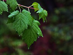
Interception [1] refers to precipitation that does not reach the soil, but is instead intercepted by the leaves, branches of plants and the forest floor. It occurs in the canopy (i.e. canopy interception), and in the forest floor or litter layer (i.e. forest floor interception [2] ). Because of evaporation, interception of liquid water generally leads to loss of that precipitation for the drainage basin, except for cases such as fog interception, but increase flood protection dramatically, Alila et al., (2009). [3]
Intercepted snowfall does not result in any notable amount of evaporation, and most of the snow falls off the tree by wind or melts. However, intercepted snow can more easily drift with the wind, out of the watershed. Conifers have a greater interception capacity than hardwoods. Their needles gives them more surface area for droplets to adhere to, and they have foliage in spring and fall, therefore interception also depends on the type of vegetation in a wooded area.
Mitscherlich in 1971 calculated the water storage potential as interception values for different species and stand densities. A storm event might produce 50 – 100 mm of rainfall and 4 mm might be the maximum intercepted in this way. Grah and Wilson in 1944 did sprinkling experiments where they watered plants to see how much of the intercepted is kept after watering stops.
Trees like Norway maple and a small-leaved lime have an interception of approximately 38% of the gross precipitation in temperate climate. [4]
The interception depends on the leaf area index and what kind of leaves they are.
Interception may increase erosion or reduce it depending on the throughfall effects.
Hydrology is the scientific study of the movement, distribution, and management of water on Earth and other planets, including the water cycle, water resources, and drainage basin sustainability. A practitioner of hydrology is called a hydrologist. Hydrologists are scientists studying earth or environmental science, civil or environmental engineering, and physical geography. Using various analytical methods and scientific techniques, they collect and analyze data to help solve water related problems such as environmental preservation, natural disasters, and water management.
A cloud forest, also called a water forest, primas forest, or tropical montane cloud forest, is a generally tropical or subtropical, evergreen, montane, moist forest characterized by a persistent, frequent or seasonal low-level cloud cover, usually at the canopy level, formally described in the International Cloud Atlas (2017) as silvagenitus. Cloud forests often exhibit an abundance of mosses covering the ground and vegetation, in which case they are also referred to as mossy forests. Mossy forests usually develop on the saddles of mountains, where moisture introduced by settling clouds is more effectively retained.
Evapotranspiration (ET) refers to the combined processes which move water from the Earth's surface into the atmosphere. It covers both water evaporation and transpiration. Evapotranspiration is an important part of the local water cycle and climate, and measurement of it plays a key role in water resource management agricultural irrigation.
In meteorology, precipitation is any product of the condensation of atmospheric water vapor that falls from clouds due to gravitational pull. The main forms of precipitation include drizzle, rain, sleet, snow, ice pellets, graupel and hail. Precipitation occurs when a portion of the atmosphere becomes saturated with water vapor, so that the water condenses and "precipitates" or falls. Thus, fog and mist are not precipitation; their water vapor does not condense sufficiently to precipitate, so fog and mist do not fall. Two processes, possibly acting together, can lead to air becoming saturated with water vapor: cooling the air or adding water vapor to the air. Precipitation forms as smaller droplets coalesce via collision with other rain drops or ice crystals within a cloud. Short, intense periods of rain in scattered locations are called showers.
Surface-water hydrology is the sub-field of hydrology concerned with above-earth water, in contrast to groundwater hydrology that deals with water below the surface of the Earth. Its applications include rainfall and runoff, the routes that surface water takes, and the occurrence of floods and droughts. Surface-water hydrology is used to predict the effects of water constructions such as dams and canals. It considers the layout of the watershed, geology, soils, vegetation, nutrients, energy and wildlife. Modelled aspects include precipitation, the interception of rain water by vegetation or artificial structures, evaporation, the runoff function and the soil-surface system itself.
Eucalyptus pauciflora, commonly known as snow gum, cabbage gum or white sally, is a species of tree or mallee that is native to eastern Australia. It has smooth bark, lance-shaped to elliptical leaves, flower buds in clusters of between seven and fifteen, white flowers and cup-shaped, conical or hemispherical fruit. It is widespread and locally common in woodland in cold sites above 700 m (2,300 ft) altitude.
Ecohydrology is an interdisciplinary scientific field studying the interactions between water and ecological systems. It is considered a sub discipline of hydrology, with an ecological focus. These interactions may take place within water bodies, such as rivers and lakes, or on land, in forests, deserts, and other terrestrial ecosystems. Areas of research in ecohydrology include transpiration and plant water use, adaption of organisms to their water environment, influence of vegetation and benthic plants on stream flow and function, and feedbacks between ecological processes, the soil carbon sponge and the hydrological cycle.
Forest ecology is the scientific study of the interrelated patterns, processes, flora, fauna, funga, and ecosystems in forests. The management of forests is known as forestry, silviculture, and forest management. A forest ecosystem is a natural woodland unit consisting of all plants, animals, and micro-organisms in that area functioning together with all of the non-living physical (abiotic) factors of the environment.
In biology, the canopy is the aboveground portion of a plant cropping or crop, formed by the collection of individual plant crowns. In forest ecology, the canopy is the upper layer or habitat zone, formed by mature tree crowns and including other biological organisms. The communities that inhabit the canopy layer are thought to be involved in maintaining forest diversity, resilience, and functioning. Shade trees normally have a dense canopy that blocks light from lower growing plants.
Infiltration is the process by which water on the ground surface enters the soil. It is commonly used in both hydrology and soil sciences. The infiltration capacity is defined as the maximum rate of infiltration. It is most often measured in meters per day but can also be measured in other units of distance over time if necessary. The infiltration capacity decreases as the soil moisture content of soils surface layers increases. If the precipitation rate exceeds the infiltration rate, runoff will usually occur unless there is some physical barrier.
Canopy interception is the rainfall that is intercepted by the canopy of a tree and successively evaporates from the leaves. Precipitation that is not intercepted will fall as throughfall or stemflow on the forest floor.
In hydrology, stemflow is the flow of intercepted water down the trunk or stem of a plant. Stemflow, along with throughfall, is responsible for the transferral of precipitation and nutrients from the canopy to the soil. In tropical rainforests, where this kind of flow can be substantial, erosion gullies can form at the base of the trunk. However, in more temperate climates stemflow levels are low and have little erosional power.
Ecological thinning is a silvicultural technique used in forest management that involves cutting trees to improve functions of a forest other than timber production.
A desert is a landscape where little precipitation occurs and, consequently, living conditions create unique biomes and ecosystems. The lack of vegetation exposes the unprotected surface of the ground to denudation. About one-third of the land surface of the Earth is arid or semi-arid. This includes much of the polar regions, where little precipitation occurs, and which are sometimes called polar deserts or "cold deserts". Deserts can be classified by the amount of precipitation that falls, by the temperature that prevails, by the causes of desertification or by their geographical location.
Rain is water droplets that have condensed from atmospheric water vapor and then fall under gravity. Rain is a major component of the water cycle and is responsible for depositing most of the fresh water on the Earth. It provides water for hydroelectric power plants, crop irrigation, and suitable conditions for many types of ecosystems.
The following outline is provided as an overview of and topical guide to hydrology:
Fog drip is water dripping to the ground during fog. It occurs when water droplets from the fog adhere to the needles or leaves of trees or other objects, coalesce into larger drops and then drop to the ground.
Forest floor interception is the part of the (net) precipitation or throughfall that is temporarily stored in the top layer of the forest floor and successively evaporated within a few hours or days during and after the rainfall event. The forest floor can consist of bare soil, short vegetation or litter. This throughfall is especially rich in nutrients which makes its redistribution into the soil is an important factor for the ecology and water demand of surrounding vegetation. As a hydrological process it is crucial for water resource management and climate change.
The biotic pump is a theoretical concept that shows how forests create and control winds coming up from the ocean and in doing so bring water to the forests further inland.
The Soil Dryness Index (SDI) uses daily rainfall and maximum temperature from local meteorological stations to estimate soil dryness across tens of kilometers. It estimates the millimeters of rain needed to fill the soil with water. The term was coined by Mount to focus attention on how useful a reliable measure of soil dryness is for flood and fire forecasting and management. Tasmanian government departments, businesses and land managers have used the SDI for these purposes for over 50 years and it is published daily by the Tasmanian Fire Service. Other states in Australia also make use of the SDI.