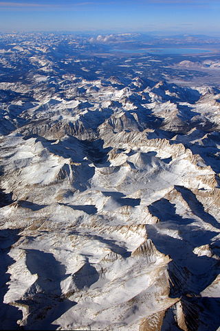
The Sierra Nevada is a mountain range in the Western United States, between the Central Valley of California and the Great Basin. The vast majority of the range lies in the state of California, although the Carson Range spur lies primarily in Nevada. The Sierra Nevada is part of the American Cordillera, an almost continuous chain of mountain ranges that forms the western "backbone" of the Americas.

Sequoia National Park is an American national park in the southern Sierra Nevada east of Visalia, California. The park was established on September 25, 1890, and today protects 404,064 acres of forested mountainous terrain. Encompassing a vertical relief of nearly 13,000 feet (4,000 m), the park contains the highest point in the contiguous United States, Mount Whitney, at 14,505 feet (4,421 m) above sea level. The park is south of, and contiguous with, Kings Canyon National Park; both parks are administered by the National Park Service together as the Sequoia and Kings Canyon National Parks. UNESCO designated the areas as Sequoia-Kings Canyon Biosphere Reserve in 1976.

The Merced River, in the central part of the U.S. state of California, is a 145-mile (233 km)-long tributary of the San Joaquin River flowing from the Sierra Nevada into the San Joaquin Valley. It is most well known for its swift and steep course through the southern part of Yosemite National Park, where it is the primary watercourse flowing through Yosemite Valley. The river's character changes dramatically once it reaches the plains of the agricultural San Joaquin Valley, where it becomes a slow-moving meandering stream.

State Route 140 is a state highway in the U.S. state of California, 102 miles (164 km) in length. It begins in the San Joaquin Valley at Interstate 5 near Gustine, and runs east into Sierra Nevada, terminating in Yosemite National Park.

The California Trail was an emigrant trail of about 1,600 mi (2,600 km) across the western half of the North American continent from Missouri River towns to what is now the state of California. After it was established, the first half of the California Trail followed the same corridor of networked river valley trails as the Oregon Trail and the Mormon Trail, namely the valleys of the Platte, North Platte, and Sweetwater rivers to Wyoming. The trail has several splits and cutoffs for alternative routes around major landforms and to different destinations, with a combined length of over 5,000 mi (8,000 km).

White Mountain Peak, at 14,252-foot (4,344 m), is the highest peak in the White Mountains of California, the highest peak in Mono County, and the third highest peak in the state after Mount Whitney and Mount Williamson. In spite of its name, the summit block of the peak has large swaths of very dark and colorful orange scree and rock as it is composed of Mesozoic metavolcanic rock - lava lifted and melted by rising granite.
North Fork is a unincorporated community in Madera County, California, United States. As of the 2020 United States census it had a population of 3,250. For statistical purposes, the United States Census Bureau has defined North Fork as a census-designated place (CDP). North Fork is part of the Madera Metropolitan Statistical Area and is home to the tribal headquarters of the Northfork Rancheria of Mono Indians of California.
The Generals Highway is a highway that connects State Route 180 and State Route 198 through Sequoia National Park, Sequoia National Forest, Giant Sequoia National Monument, and Kings Canyon National Park in the Sierra Nevada of California. As the road goes through national parks and monuments, the highway is primarily maintained by the federal government instead of a California State Highway controlled by Caltrans.

Eldorado National Forest is a U.S. National Forest located in the central Sierra Nevada mountain range, in eastern California.

State Route 88 (SR 88), also known as the Carson Pass Highway, is a state highway in the U.S. state of California. It travels in an east–west direction from Stockton, in the San Joaquin Valley, to the Nevada state line, where it becomes Nevada State Route 88, eventually terminating at U.S. Route 395 (US 395). The highway is so named as it crests the Sierra Nevada at Carson Pass. The highway corridor predates the era of the automobile; the path over Carson pass was previously used for the California Trail and the Mormon Emigrant Trail. The mountainous portion of the route is included in the State Scenic Highway System.

Mineral King is a subalpine glacial valley located in the southern part of Sequoia National Park, in the U.S. state of California. The valley lies at the headwaters of the East Fork of the Kaweah River, which rises at the eastern part of the valley and flows northwest. Accessed by a long and narrow winding road, the valley is mostly popular with backpackers and hikers.

Interstate 80 (I-80) is a transcontinental Interstate Highway in the United States, stretching from San Francisco, California, to Teaneck, New Jersey. The segment of I-80 in California runs east from San Francisco across the San Francisco–Oakland Bay Bridge to Oakland, where it turns north and crosses the Carquinez Bridge before turning back northeast through the Sacramento Valley. I-80 then traverses the Sierra Nevada, cresting at Donner Summit, before crossing into the state of Nevada within the Truckee River Canyon. The speed limit is at most 65 mph (105 km/h) along the entire route instead of the state's maximum of 70 mph (110 km/h) as most of the route is in either urban areas or mountainous terrain. I-80 has portions designated as the Eastshore Freeway and Alan S. Hart Freeway.

U.S. Route 50 (US 50) is a transcontinental United States Numbered Highway, stretching from West Sacramento, California, in the west to Ocean City, Maryland, in the east. The California portion of US 50 runs east from Interstate 80 (I-80) in West Sacramento to the Nevada state line in South Lake Tahoe. A portion in Sacramento also has the unsigned designation of Interstate 305. The western half of the highway in California is a four-or-more-lane divided highway, mostly built to freeway standards, and known as the El Dorado Freeway outside of downtown Sacramento. US 50 continues as an undivided highway with one eastbound lane and two westbound lanes until the route reaches the canyon of the South Fork American River at Riverton. The remainder of the highway, which climbs along and out of the canyon, then over the Sierra Nevada at Echo Summit and into the Lake Tahoe Basin, is primarily a two-lane road.

The Sierra Vista Scenic Byway is an 82.7-mile (133.1 km) route through the Sierra National Forest in the U.S. state of California. Many examples of the Sierra’s most distinctive granite domes, meadows and glacial valleys can be seen along the way. The Sierra Vista Scenic Byway begins two miles (3 km) north of the foothill community of North Fork, climbing the western slope of the Sierra Nevada mountain range until its crest, and finally dropping back down into the foothills near Oakhurst.

The Bear River is a tributary of the Feather River in the Sierra Nevada, winding through four California counties: Yuba, Sutter, Placer, and Nevada. About 73 miles (117 km) long, the river flows generally southwest through the Sierra then west through the Central Valley, draining a narrow, rugged watershed of 295 square miles (760 km2).
The Piper Mountain Wilderness is a federally designated wilderness area located in the White Mountains 20 miles (32 km) northeast of Big Pine, California in Inyo County, California.

The Middle Fork American River is one of three forks that form the American River in Northern California. It drains a large watershed in the high Sierra Nevada west of Lake Tahoe and northeast of Sacramento in Placer and El Dorado Counties, between the watersheds of the North Fork American River and South Fork American River. The Middle Fork joins with the North Fork near Auburn and they continue downstream to Folsom Lake as the North Fork, even though the Middle Fork carries a larger volume of water.

Sugar Pine Reservoir is a reservoir in Placer County, California, located approximately 7 miles (11 km) north of Foresthill. The reservoir was flooded in 1982, and today supplies water to the community of Foresthill and hosts a number of recreation facilities.

Independence Lake is a natural glacial lake in the Sierra Nevada of California. At an elevation of 6,949 feet (2,118 m) in the upper reaches of the Truckee River basin, it has been less affected by development than most lakes in the area. The Nature Conservancy owns a 2,325 acres (9.41 km2) parcel of land around it, which it manages privately as the Independence Lake Preserve for the purposes of conservation and low-impact recreation.


