Iriri River

Last updated • 1 min readFrom Wikipedia, The Free Encyclopedia
Iriri River
Iriririvermap.png
Iriri River
Native name
Location
Country Brazil
Physical characteristics
Source 
  location Pará, Brazil
  elevation619 m (2,031 ft)
Mouth Xingu River
  coordinates
3°49′00″S52°36′20″W / 3.81667°S 52.60556°W / -3.81667; -52.60556
  elevation
116 m (381 ft)
Length1,151 km (715 mi) [2]
Basin size141,943 km2 (54,804 sq mi) [2]
Discharge 
  locationConfluence of Xingu (near mouth)
  average3,028 m3/s (106,900 cu ft/s) [2]
  minimum56.3 m3/s (1,990 cu ft/s) [2]
  maximum14,025 m3/s (495,300 cu ft/s) [2]
Discharge 
  locationPedra do Ó gauge station (130 km upstream of mouth - Basin size 123,827 km2 (47,810 sq mi)
  average2,748 m3/s (97,000 cu ft/s) [2]
  minimum49 m3/s (1,700 cu ft/s) [2]
  maximum12,235 m3/s (432,100 cu ft/s) [2]
Basin features
Tributaries 
  left Curuá River, Catete River, Chiché River, Ipiranga River
  right Novo River, Carajarí River, Xinxim River, Iriri Novo River

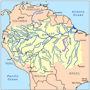
The Iriri River (Portuguese : Rio Iriri [ˈʁi.uiɾiˈɾi] ; Mẽbêngôkre : Kororoti [kɔˌɾɔɾɔˈti] [1] :40) is a large tributary of the Xingu River in Brazil, in the state of Pará. It is 1,300 km (810 mi) long making it the 116th longest river in the world (with Krishna River, India) and the 15th longest in the Amazon basin. The headwaters are the traditional home of the Panará people.

Contents

Course

The river rises in the 342,192-hectare (845,570-acre) Nascentes da Serra do Cachimbo Biological Reserve, a strictly protected conservation unit established in 2005 in the Serra do Cachimbo. It is one of the headwaters of the Xingu River. [3] It flows for 900 kilometres (560 mi) before joining the Xingu, running through the 3,373,133.89-hectare (8,335,195.4-acre) Terra do Meio Ecological Station. The river varies greatly in volume depending on the season, and in the dry season includes waterfalls, rocks and rapids. [4]

The Iriri River flows through the Tapajós–Xingu moist forests ecoregion. [5] The river is rich in fish, including many species found only there and in the Xingu. Large sections remain unexplored due to its remoteness in a region surrounded by Amazon rainforest, and sections with strong current and cataracts. [6]

Related Research Articles

<span class="mw-page-title-main">Altamira, Pará</span> Place in Northern Region, Brazil

Altamira is one of one hundred and forty-four municipalities in the state of Pará, in northern Brazil. It has an area of 159,533.73 square kilometres or 61,596.32 square miles, making it the largest municipality by area both in Pará state and Brazil, and until 2009 it was the world's largest municipal subdivision. It occupies 12.8% of the state's territory, 1.8% of Brazil's territory and 0.8% of South America. It also covers a more extensive area than 104 countries, and is comparable to the US states of Missouri and Florida.

The Jutaí-Solimões Ecological Station is an ecological station in the state of Amazonas, Brazil. It protects an area of flooded and terra firme forest in the Amazon biome.

Rio Acre Ecological Station is an ecological station in the state of Acre, Brazil.

Serra das Araras Ecological Station is an ecological station in Mato Grosso, Brazil. It contains a sample of the Cerrado biome.
<span class="mw-page-title-main">Formosa do Rio Preto</span> Municipality in Northeast, Brazil

Formosa do Rio Preto is the westernmost and largest city in the Brazilian state of Bahia. It is also the largest in all Northeastern Brazil.

<span class="mw-page-title-main">Oriximiná</span> Place in Norte, Brazil

Oriximiná is the westernmost and second-largest municipality in the Brazilian state of Pará. It is also the fourth-largest in the country.

<span class="mw-page-title-main">Mateiros</span> Municipality in North, Brazil

Mateiros is the easternmost city in the state of Tocantins. It is the only city in Tocantins to border the state of Piauí.

The Curuaés River is a river of Pará state in north-central Brazil. It is a right tributary of the Curuá River in the Xingu River basin.
<span class="mw-page-title-main">Curuá River (Iriri River tributary)</span> River in Brazil

The Curuá River is a tributary of the Iriri River in Pará state in north-central Brazil. The river flows through the Tapajós-Xingu moist forests ecoregion. The river rises in the 342,192 hectares Nascentes da Serra do Cachimbo Biological Reserve, a strictly protected conservation unit established in 2005. It is one of the headwaters of the Xingu River.

The Ipiranga River is a tributary of the Iriri River in Pará state in north-central Brazil.

<span class="mw-page-title-main">Cristalino River (Teles Pires)</span> River in Brazil

The Cristalino River is a river of the states of Pará and Mato Grosso in western Brazil. It is a tributary of the Teles Pires.

<span class="mw-page-title-main">Macacu River</span> River in Brazil

The Macacu River is a river of Rio de Janeiro state in southeastern Brazil.

<span class="mw-page-title-main">São Félix do Xingu</span> Municipality in Northern, Brazil

São Félix do Xingu is a municipality in the state of Pará in the Northern region of Brazil.

<span class="mw-page-title-main">Novo Progresso</span> Municipality in Northern, Brazil

Novo Progresso is a municipality in the state of Pará in the Northern region of Brazil.

Serra do Cachimbo is a low mountain range in the southern part of the state of Pará, Brazil. It is located mostly in the municipalities of Altamira, Itaituba, Jacareacanga, and Novo Progresso.

Cuniã Ecological Station is a strictly protected ecological station in the states of Amazonas and Rondônia, Brazil. It preserves an area of savannah parkland on the border of the Amazon rainforest. The conservation unit is rich in lakes and ponds, and serves as a nursery for various species of fish.

The Nascentes da Serra do Cachimbo Biological Reserve is a biological reserve in the state of Pará, Brazil. The reserve protects an area in the transition between the Cerrado and Amazon biomes, supporting highly diverse flora and fauna including many endemic species. It is accessible via the BR-163 highway, and is among the federal conservation units in the Amazon Legal that has suffered most from deforestation.

<span class="mw-page-title-main">Rio Novo National Park</span> National park in Pará, Brazil

Rio Novo National Park is a national park in the state of Pará, Brazil.

<span class="mw-page-title-main">Terra do Meio Ecological Station</span> Ecological station in Brazil

Terra do Meio Ecological Station is an ecological station (ESEC) in the state of Pará, Brazil.

Altamira National Forest is a national forest in the state of Pará, Brazil.
References

  1. 1 2 Passos, João Lucas Moraes (2018). Caminhos mẽbêngôkre: andando, nomeando, sentando sobre a terra (Ph.D. thesis). Brasília: Universidade de Brasília.
  2. 1 2 3 4 5 6 7 8 "Conhecimento Técnico e a regulação ambiental na Amazônia: A utilização da bacia hidrográfica nos EIA/RIMA das UHE do Rio Madeira e de Belo Monte". 2015.
  3. Unidade de Conservação: Reserva Biológica...
  4. Unidade de Conservação: Estação Ecológica ...
  5. Sears.
  6. Bleher 2009.

Sources