
The Alpine Lakes Wilderness is a large wilderness area spanning the Central Cascades of Washington state in the United States. The wilderness is located in parts of Wenatchee National Forest and Snoqualmie National Forest, and is approximately bounded by Interstate 90 and Snoqualmie Pass to the south and U.S. Route 2 and Stevens Pass to the north. The Alpine Lakes is the largest wilderness area near the population centers of Puget Sound, counted at 414,161 acres (167,605 ha) following the 2014 expansion.
The Potomac Highlands of West Virginia centers on five West Virginian counties in the upper Potomac River watershed in the western portion of the state's Eastern Panhandle, bordering Maryland and Virginia. Because of geographical proximity, similar topography and landscapes, and shared culture and history, the Potomac Highlands region also includes Pocahontas, Randolph, and Tucker counties, even though they are in the Monongahela River or New River watersheds and not that of the Potomac River.
Foss River Falls is a 650-foot (200 m) drop on the West Fork Foss River in the Alpine Lakes Wilderness Area, King County, Washington. Its sources are at Delta Lake, and the 70-foot (21 m)-wide drop flows year-round. The waterfall is split into two parts. Each part is split into several tiers.
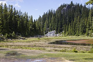
The valley of the West Fork Foss River contains a fair amount of waterfalls. The river heads in a series of large lakes: Big Heart Lake, Angeline Lake, and Otter Lake- which form spectacular waterfalls as they plunge down to Delta Lake. On the valley walls downstream of Delta Lake, are found even more waterfalls.
The Foss River is a stream in the U.S. state of Washington. It has two main forks, the East Fork Foss River and the West Fork Foss River. The main stem is formed by the confluence of the two forks. The river and its forks rise near in the Alpine Lakes Wilderness area of Mount Baker-Snoqualmie National Forest in the Cascade Mountains and flows generally north, joining the Tye River to form the South Fork Skykomish River. The Foss River's waters eventually empty into Puget Sound near Everett via the Skykomish River and Snohomish River.

Iron Cap Mountain is a 6,347-foot (1,935-metre) mountain summit located two miles west-northwest of Dutch Miller Gap, in east King County of Washington state. It is situated in the heart of the Alpine Lakes Wilderness, on land managed by Mount Baker-Snoqualmie National Forest. Iron Cap Mountain is set two miles west of the crest of the Cascade Range. Precipitation runoff from the south side of the mountain drains into tributaries of the Snoqualmie River, whereas the north side drains into tributaries of the Foss River. Although modest in elevation, relief is significant since Iron Cap rises 2,500 feet above the Middle Fork Snoqalmie River Valley in less than one mile. Its neighbors include La Bohn Peak, 1.77 miles (2.85 km) to the east, and Little Big Chief Mountain, 2.14 miles (3.44 km) to the southeast.

Bald Eagle Peak is a 6,259-foot (1,908-metre) mountain summit located 7.4 mi (11.9 km) southeast of Skykomish, in eastern King County of Washington state. It's part of the Cascade Range, and is situated in the Alpine Lakes Wilderness, on land managed by Mount Baker-Snoqualmie National Forest. Precipitation runoff from this mountain drains into tributaries of the Foss River. This peak is set on the divide between the east and west forks of Foss River. The nearest neighbor is Silver Eagle Peak, 1.1 mi (1.8 km) to the southwest, and Bald Eagle Lake lies in a cirque midway between the pair. The first ascent of this peak was made in 1933 by Hermann Ulrichs and Ben Falkenburg via the North Ridge. This mountain's toponym and correct location was officially adopted September 8, 1988, by the U.S. Board on Geographic Names. Some older maps will have this peak erroneously labeled at Silver Eagle Peak's location.
Alturas Lake is a freshwater lake located on the northern slope of Bald Eagle Peak, in King County, Washington. Alturas Lake drains North towards Tonga Ridge and into the East Fork of the Foss River.
Angeline Lake is a freshwater lake located on the northern slope of Iron Cap Mountain between Otter Lake, Azure Lake and Big Heart Lake, in King County, Washington. Self-issued Alpine Lake Wilderness permit required for transit within the Big Snow Mountain area. West Fork Foss River exits Angeline Lake into a canyon that produces Angeline Falls downstream from Chetwoot Lake to Delta Lake. Because Angeline Lake is at the heart of the Alpine Lakes Wilderness, the lake is a popular area for hiking, swimming, and fishing golden trout, rainbow trout, and cutthroat trout.
Chetwoot Lake is a freshwater lake located on the western slope of Iron Cap Mountain next to Crawford Lake, in King County, Washington. West Fork Foss River exits Chetwoot Lake towards Angeline Lake and then to a canyon that produces Angeline Falls downstream towards Delta Lake. Because Chetwoot Lake is at the heart of the Alpine Lakes Wilderness, the lake is a popular area for hiking, swimming, and fishing.
Opal Lake, also known as Necklace Valley Lake 3, is a freshwater lake located on the western region of the Alpine Lakes Wilderness, in King County, Washington. The lake is connected by stream to Emerald Lake and Jade Lake, which form together the Neckelace Valley Lakes. Opal Lake and its surrounding lakes and peaks are a popular area for hiking, swimming, and fishing Rainbow trout. Self-issued Alpine Lake Wilderness permit required for transit within the Necklace Valley area.
Otter Lake is a freshwater lake located on the western slope of Otter Point northwest of Maple Valley in King County, Washington. Self-issued Alpine Lake Wilderness permit required for transit within the Big Snow Mountain area. Other prominent lakes are west of Otter Lake, including Angeline Lake, Azurite Lake and Big Heart Lake, while Opal Lake and other Necklace Valley lakes are on the eastern slope of Otter Point. Because Otter Lake is at the heart of the Alpine Lakes Wilderness, the lake is a popular area for hiking, swimming, and fishing.
Azurite Lake is a freshwater lake located in the Alpine Lakes Wilderness, between Otter Lake and Angeline Lake in King County, Washington. A short distance south towards Iron Cap Mountain is Azure Lake and Iron Cap Lake. The south shore of the lake rests on a prominent granite ledge up towards a hillock and steep heathland that lead to Iron Cap Mountain. The North shore of the lake is bound by the steep slopes of Saint Agnes Ridge which continue on the eastern slopes of Angeline Lake. Self-issued Alpine Lake Wilderness permit required for transit within the Necklace Valley area.
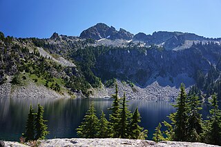
Azure Lake is a small freshwater lake located in the Alpine Lakes Wilderness, between Azurite Lake and Angeline Lake in King County, Washington. A short distance south towards Iron Cap Mountain is Iron Cap Lake. Towards the North are the steep slopes of Saint Agnes Ridge which continue eastwards towards Otter Lake. Self-issued Alpine Lake Wilderness permit required for transit within the Necklace Valley area. Azure Lake is located in a prominent valley along the southern skirt of the Mount Daniel area in connection with the North-Middle Forks Snoqualmie mountain grouping area.
Crawford Lake is a freshwater lake located in the Alpine Lakes Wilderness, at the western ridge of Iron Cap Mountain in King County, Washington. The lake is nestled on a set of prominent valleys and peaks and produces Crawford Creek which flows as one of many tributaries of the Middle Fork Foss River. A short distance towards the north are Chetwoot Lake, Angeline Lake and the Necklace Valley Lakes. Self-issued Alpine Lake Wilderness permit required for transit within the Necklace Valley area.
Bonnie Lake is a small freshwater lake located in the Alpine Lakes Wilderness, south of Otter Lake and the Necklace Valley lakes in King County, Washington. Two waterfalls are found neighboring the lake, one at the eastern inflow and the other at the western outflow: Upper and Lower Bonnie Lake Falls respectively. A short distance towards the South are Iron Cap Mountain and Iron Cap Lake. Bonnie Lake is surrounded by forests except on the eastern side, which is largely composed of vegetated bedrock, talus, and avalanche tracks. Self-issued Alpine Lake Wilderness permit required for transit within the Necklace Valley area.
Delta Lake is a freshwater lake located in the Alpine Lakes Wilderness, north of the Necklace Valley lakes in King County, Washington. Because Delta lake is at the heart of the Alpine Lakes Wilderness, the lake is a popular area for hiking, swimming, and fishing rainbow trout, and cutthroat trout. Delta Lake is a consequence of the spill of the outlets of three major Alpine Lakes: Otter Lake, Big Heart Lake, and Angeline Lake. The West Fork of the Foss River exits Delta Lake in two outlets which merge into one stream shortly above the top of Upper Foss River Falls.

Bald Eagle Lake is a freshwater lake located on the north skirt of Screeching Eagle Peak, a U-shaped ridge massif formed by the junction of Bald Eagle Peak and Silver Eagle Peak, between the West Fork and East Fork of Foss River, in King County, Washington. Other prominent lakes are south of Bald Eagle Lake, including Locket Lake, Otter Lake and Lake Iiswoot, Opal Lake and other Necklace Valley lakes on the eastern slope of Otter Point. Mount Hinman and Mount Daniel are a short distance southeast. Because Bald Eagle Lake is at the heart of the Alpine Lakes Wilderness, the lake is a popular area for hiking, swimming, and fishing.
Myrtle Lake is a freshwater lake located on the northern slope of Big Snow Mountain between Snoqualmie Lake and Chetwoot Lake, in King County, Washington. Self-issued Alpine Lake Wilderness permit required for transit within the Big Snow Mountain area. Because Myrtle Lake is at the heart of the Alpine Lakes Wilderness, the lake is a popular area for hiking, swimming, and fishing rainbow trout and coastal cutthroat trout.
Gold Lake is a freshwater lake located on a valley on the west skirt of Wild Goat Peak, in King County, Washington. Gold Lake is surrounded by prominent peaks and lakes at the heart of the Alpine Lakes Wilderness, including Big Snow Mountain and Iron Cap Mountain.


