
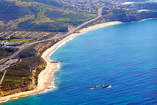
The Santa Ana River is the largest river entirely within Southern California in the United States. It rises in the San Bernardino Mountains and flows for most of its length through San Bernardino and Riverside counties, before cutting through the northern Santa Ana Mountains via Santa Ana Canyon and flowing southwest through urban Orange County to drain into the Pacific Ocean. The Santa Ana River is 96 miles (154 km) long, and its drainage basin is 2,650 square miles (6,900 km2) in size.
Rancho Santiago de Santa Ana was a 63,414-acre (256.63 km2) Spanish land concession in present-day Orange County, California, given by Spanish Alta California Governor José Joaquín de Arrillaga in 1810 to Jose Antonio Yorba and his nephew Pablo Peralta. The grant extended eastward from the Santa Ana River to the Santa Ana Mountains, with a length of more than 22 miles (35 km).

The Los Vaqueros Reservoir and watershed is located in the northern Diablo Range, within northeastern Contra Costa County, northern California. It was completed by the Contra Costa Water District (CCWD) in 1998 to improve the quality of drinking water for its 550,000 customers in Central and Eastern Contra Costa County. The reservoir is accessible via Vasco Road, a road which connects Brentwood and Livermore.

Aliso Creek is a 19.8-mile (31.9 km)-long, mostly urban stream in south Orange County, California. Originating in the Cleveland National Forest in the Santa Ana Mountains, it flows generally southwest and empties into the Pacific Ocean at Laguna Beach. The creek's watershed drains 34.9 square miles (90 km2), and it is joined by seven main tributaries. As of 2018, the watershed had a population of 144,000 divided among seven incorporated cities.

Coyote Lake is an artificial lake in Santa Clara County, California, United States, between Morgan Hill and Gilroy.

Santiago Creek is a major watercourse in Orange County in the U.S. state of California. About 34 miles (55 km) long, it drains most of the northern Santa Ana Mountains and is a tributary to the Santa Ana River. It is one of the longest watercourses entirely within the county. The creek shares its name with Santiago Peak, at 5,687 ft (1,733 m) the highest point in Orange County, on whose slopes its headwaters rise.

Scofield Reservoir is a 2,815-acre (11.39 km2) reservoir impounded by Scofield Dam, in Carbon County, Utah. Located on the Price River, a tributary of the Green River, Scofield Reservoir is adjacent to the northernmost boundary of the Manti–La Sal National Forest. The reservoir sits at an elevation of 7,618 feet (2,322 m), on the northern edge of the Wasatch Plateau. Utah State Route 96 runs along the western shoreline.

San Diego Creek is a 16-mile (26 km) urban waterway flowing into Upper Newport Bay in Orange County, California, United States. Its watershed covers 112.2 square miles (291 km2) in parts of eight cities, including Irvine, Tustin, and Costa Mesa. From its headwaters in Laguna Woods the creek flows northwest to its confluence with Peters Canyon Wash, where it turns abruptly southwest towards the bay. Most of the creek has been converted to a concrete flood control channel, but it also provides important aquatic and riparian habitat along its course and its tidal estuary.

Sulphur Creek is an approximately 4.5-mile (7.2 km) tributary of Aliso Creek in Orange County, California. The creek drains about 6 square miles (16 km2) in the suburban cities of Laguna Niguel and Laguna Hills. Although most of its watershed has been utilized for master planned residential development, the creek retains a natural channel with riparian and wetland habitat in parts of Laguna Niguel Regional Park and Aliso and Wood Canyons Regional Park. Urban runoff has changed the once seasonal creek into a perennial stream.

Sly Park Dam is located near Pollock Pines, California in the United States. The dam impounds Sly Park Creek and Hazel Creek, natural tributaries of the North Fork Cosumnes River, to form a 41,000 acre-foot (51,000 dam3), 650-acre (260 ha) reservoir called Jenkinson Lake. It was constructed as part of the American River Division of the Central Valley Project to provide irrigation water to a portion of El Dorado County, California. The dam was begun in May 1953, with clearing operations, and was completed in mid 1955.

Sulphur Creek Dam is a dam across Sulphur Creek in Orange County, California. The dam creates Laguna Niguel Lake and is entirely within the city of Laguna Niguel. The reservoir is used for water reclamation storage and recreation, and is the main attraction of Laguna Niguel Regional Park, which surrounds it.
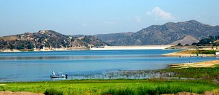
Santiago Dam is an earth/rockfill dam across Santiago Creek in Orange County, in the U.S. state of California, forming Irvine Lake. The 136-foot (41 m) earth dam and its reservoir serve for flood control and recreational purposes. It lies upstream (southeast) from the city of Orange and north of Irvine. Irvine Lake is the largest body of fresh water entirely in Orange County.

Peters Canyon Regional Park is a regional park within the Orange County Regional Parks System in California. The park contains 354 acres of southern California wildlife, including coastal sage shrub, riparian, freshwater marsh, and grasslands, and is located within the boundaries of both Orange, California and Tustin, California. Peters Canyon was given to this city in 1992 by the Irvine Company who had used it previously for cattle grazing. The canyon is lined with a residential area on one side and open hills on the other. This canyon is commonly used by hikers, mountain bikers, and equestrians because of the trails that circumvent the 50 acre man-made lake, which was constructed by the Irvine Company in 1931, on the interior of the plot. The regional park is open from 7:00 AM to sunset every day of the week, save for the chance of rain or hazardous conditions, in which case the park will be closed for three days following the particular occurrence.
The Irvine Ranch Natural Landmarks are a collection of protected areas in Orange County, California in and around Irvine. They encompass almost 50,000 acres (20,000 ha) of land which was once a part of the Irvine Ranch owned by the Irvine Company. Almost 40,000 acres (16,000 ha) of the landmarks were designated a National Natural Landmark in 2006 and a California Natural Landmark in 2008.

Carbon Canyon Regional Park is a regional park in Brea, California, that was created after the Carbon Canyon Creek was dammed. It links up with Chino Hills State Park on the east side. The park also is home to a small forest of Redwood trees, which have been struggling to survive since the start of the 2010 California drought.
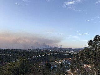
The Silverado Fire was a wildfire that burned in October and November 2020 in southern Orange County, California northeast of Irvine. The fire started on October 26 around 6:47 AM near Orange County Route S-18 and Silverado Canyon Road, fueled by strong Santa Ana winds gusting up to 80 miles per hour (130 km/h) and low humidity. Orange County Fire Authority Chief Brian Fennessy stated, "The winds were extraordinary even by Santa Ana standards. Fire spread is exceeding more than anything I've seen in my 44 years." The fire initially moved south from Loma Ridge toward the Orchard Hills, Northwood and Portola Springs communities of Irvine before moving southeast through Limestone Canyon and toward the communities of Foothill Ranch and Lake Forest. The fire burned in a path similar to that taken by the 2007 Santiago Fire, mostly through terrain that had not seen significant burning in the 13 years since that fire. 100% containment was announced on November 7, 2020.
The Municipal Water District of Orange County, commonly known by the acronym MWDOC, is a wholesale water provider, water resource development and planning agency., water-centric information, education, emergency planning, and conservation resource hub for nearly 3.2 millionOrange County, California residents, and businesses. Local water supply sources meet only about half of the region's total water needs. To fulfill the remaining demand, MWDOC buys imported water from the California State Water Project in northern California and the Colorado River through the Metropolitan Water District of Southern California (Metropolitan). MWDOC delivers water to its 27 member agencies - made up of both water districts and city water departments - who then, in turn, provide retail water service to the public.

Whiting Ranch Wilderness Park is a 2,500 acre public regional park within the city of Lake Forest in southern Orange County, California. Whiting Ranch features riparian, oak woodland, grassland, chaparral, and coastal sage scrub environments throughout various canyons and hillscapes. The park is home to over 17 miles of trail spread out over 23 different paths, making the location a popular destination for mountain bikers, hikers, and horseback riders.

Limestone Canyon Regional Park is a public regional park in southern Orange County, California under the management of OC Parks. The 4,000 acre park is a part of the Irvine Ranch Open Space, a designation of preserved natural landmarks in Southern California. The premises is near Santiago Canyon and at the foothills of the Santa Ana Mountains, making it a neighbor to the Cleveland National Forest. The park is just outside of the cities of Lake Forest and Irvine and is accessible via County Route S18. Limestone Canyon borders Whiting Ranch Wilderness Park, another regional park in the area. The region was privately owned by The Irvine Company until it was donated to the county in June 2010, along with 20,000 acres of what was Irvine Ranch.
The Serrano Water District is a California special district that maintains the groundwater of parts of eastern Orange County. The agency serves a 4.7 square mile area that encompasses the entirety of Villa Park and a small portion of Orange. The population served is approximately 6,500.


