Related Research Articles

Somerset is a county in South West England which borders Gloucestershire and Bristol to the north, Wiltshire to the east, Dorset to the south-east and Devon to the south-west. It is bounded to the north and west by the Severn Estuary and the Bristol Channel, its coastline facing southeastern Wales. Its traditional border with Gloucestershire is the River Avon. Somerset's county town is Taunton.
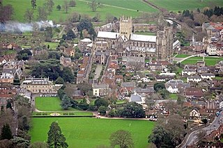
Wells is a city and civil parish in the Mendip district of Somerset, located on the southern edge of the Mendip Hills, 21 miles (34 km) south-east of Weston-super-Mare, 22 miles (35 km) south-west of Bath and 23 miles (37 km) south of Bristol. Although the population recorded in the 2011 census was only 10,536, and with a built-up area of just 3.244 square kilometres, Wells has had city status since medieval times, because of the presence of Wells Cathedral. Often described as England's smallest city, it is actually second smallest to the City of London in area and population, but unlike London it is not part of a larger urban agglomeration.

The Fosse Way was a Roman road built in Britain during the first and second centuries AD that linked Exeter in the southwest and Lincoln to the northeast, via Ilchester, Bath, Cirencester and Leicester.

The Mendip Hills is a range of limestone hills to the south of Bristol and Bath in Somerset, England. Running from Weston-super-Mare and the Bristol Channel in the west to the Frome valley in the east, the hills overlook the Somerset Levels to the south and the Chew Valley and other tributaries of the Avon to the north. The hills give their name to the local government district of Mendip, which administers most of the area. The higher, western part of the hills, covering 198 km2 (76 sq mi) has been designated an Area of Outstanding Natural Beauty (AONB), which gives it a level of protection comparable to a national park.

Axbridge is a small town in Somerset, England, in the Sedgemoor district on the River Axe, near the southern edge of the Mendip Hills. The town's population according to the 2011 census was 2,057.
Somerset is a historic county in the south west of England. There is evidence of human occupation since prehistoric times with hand axes and flint points from the Palaeolithic and Mesolithic eras, and a range of burial mounds, hill forts and other artefacts dating from the Neolithic, Bronze and Iron Ages. The oldest dated human road work in Great Britain is the Sweet Track, constructed across the Somerset Levels with wooden planks in the 39th century BCE.

Bleadon is a village and civil parish in Somerset, England. It is about 4 miles (6.4 km) south of Weston-super-Mare and, according to the 2011 census, has a population of 1,079.

Somerset is a rural county in the southwest of England, covering 4,171 square kilometres (1,610 sq mi). It is bounded on the north-west by the Bristol Channel, on the north by Bristol and Gloucestershire, on the north-east by Wiltshire, on the south-east by Dorset, and on the south west and west by Devon. It has broad central plains with several ranges of low hills. The landscape divides into four main geological sections from the Silurian through the Devonian and Carboniferous to the Permian which influence the landscape, together with water-related features.

Dolebury Warren is a 90.6 hectares biological Site of Special Scientific Interest (SSSI) and ancient monument near the villages of Churchill and Rowberrow in North Somerset, part of South West England. It is owned by the National Trust, who acquired the freehold in 1983, and managed by the Avon Wildlife Trust.

Priddy is a village in Somerset, England in the Mendip Hills, close to East Harptree and 4 miles (6 km) north-west of Wells. It is in the local government district of Mendip.

Charterhouse, also known as Charterhouse-on-Mendip, is a hamlet in the Mendip Hills Area of Outstanding Natural Beauty (AONB) in the English county of Somerset. The area between Charterhouse and Cheddar Gorge including Velvet Bottom and Ubley Warren is covered by the Cheddar Complex Site of Special Scientific Interest.

Charterhouse was a town in the Roman province of Britannia. Its site is located just to the west of the village of Charterhouse-on-Mendip in the English county of Somerset.
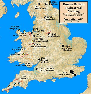
Mining was one of the most prosperous activities in Roman Britain. Britain was rich in resources such as copper, gold, iron, lead, salt, silver, and tin, materials in high demand in the Roman Empire. Sufficient supply of metals was needed to fulfill the demand for coinage and luxury artefacts by the elite.The Romans started panning and puddling for gold. The abundance of mineral resources in the British Isles was probably one of the reasons for the Roman conquest of Britain. They were able to use advanced technology to find, develop and extract valuable minerals on a scale unequaled until the Middle ages.

Uphill is a village in the civil parish of Weston-super-Mare in North Somerset, England, at the southern edge of the town, on the Bristol Channel coast.
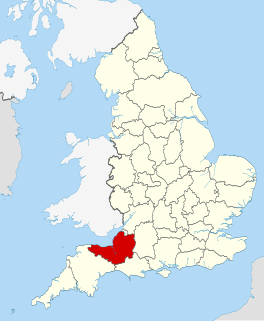
The county of Somerset is in South West England, bordered by the Bristol Channel and the counties of Bristol and Gloucestershire to the north, and Wiltshire to the east, Dorset to the south, and Devon to the west. The climate, influenced by its proximity to the Atlantic Ocean and the prevailing westerly winds, tends to be mild, damp and windy.

Charterhouse Camp is a univallate Iron Age hill fort in the Mendip district of Somerset, England. The hill fort is situated approximately 0.6 miles (0.97 km) east from the village of Charterhouse. There is some evidence, in the form of burials in local caves, of human occupation since the late Neolithic times and the early Bronze Age. The site is associated with Charterhouse Roman Town and may have been the site of Iscalis.

Gatcombe at Ashton Watering within the civil parish of Long Ashton, Somerset, England, is the location of a Grade II* listed building which was built on the site of a Roman settlement.

The Cheddar Palace was established in the 9th century, in Cheddar, Somerset, England. It was a royal hunting lodge in the Anglo-Saxon and medieval periods and hosted the Witenagemot in the 10th century.

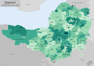
There are over 670 scheduled monuments in the ceremonial county of Somerset in South West England. The county consists of a non-metropolitan county, administered by Somerset County Council, which is divided into five districts, and two unitary authorities. The districts of Somerset are West Somerset, South Somerset, Taunton Deane, Mendip and Sedgemoor. The two administratively independent unitary authorities, which were established on 1 April 1996 following the breakup of the county of Avon, are North Somerset and Bath and North East Somerset. These unitary authorities include areas that were once part of Somerset before the creation of Avon in 1974.
References
- ↑ Cunliffe, Barry (1967). "Excavations at Gatcombe, Somerset, in 1965 and 1966" (PDF). Proceedings of the University of Bristol Spelæological Society. 11 (2): 126–60. Retrieved 30 April 2011.
- ↑ Historic England. "Gatcombe Settlement (197955)". Research records (formerly PastScape). Retrieved 30 April 2011.
- ↑ Rivet, A. L. F.; Smith, Colin (1979). The Place-Names of Roman Britain. London: BT Batsford.
- ↑ Elkington, H. D. H. (1976). "The Mendip Lead Industry". The Roman West Country: Classical Culture and Celtic Society.
- ↑ Havinden, Michael (1981). The Somerset Landscape. The making of the English landscape. London: Hodder and Stoughton. pp. 58–9. ISBN 0-340-20116-9.
- ↑ Dunning, Robert (1983). A History of Somerset. Chichester: Phillimore & Co. ISBN 978-0-85033-461-6.
- ↑ "ISCALIS Suspected Romano-British Settlement". Roman Britain. Archived from the original on 14 May 2011. Retrieved 1 May 2011.
- ↑ Historic England. "Roman settlement site, Anglo-Saxon and Norman royal palace, and St Columbanus' Chapel (1017290)". National Heritage List for England . Retrieved 26 May 2014.