
Cheddar is a large village and civil parish in the Sedgemoor district of the English county of Somerset. It is situated on the southern edge of the Mendip Hills, 9 miles (14 km) north-west of Wells, 11 miles (18 km) south-east of Weston-super-Mare and 18 miles (29 km) south-west of Bristol. The civil parish includes the hamlets of Nyland and Bradley Cross. The parish had a population of 5,755 in 2011 and an acreage of 8,592 acres (3,477 ha) as of 1961.

Anglo-Saxon architecture was a period in the history of architecture in England, and parts of Wales, from the mid-5th century until the Norman Conquest of 1066. Anglo-Saxon secular buildings in Britain were generally simple, constructed mainly using timber with thatch for roofing. No universally accepted example survives above ground.

Glastonbury Abbey was a monastery in Glastonbury, Somerset, England. Its ruins, a grade I listed building and scheduled ancient monument, are open as a visitor attraction.
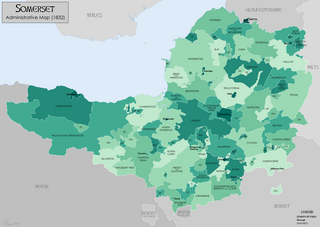
Somerset is a historic county in the south west of England. There is evidence of human occupation since prehistoric times with hand axes and flint points from the Palaeolithic and Mesolithic eras, and a range of burial mounds, hill forts and other artefacts dating from the Neolithic, Bronze and Iron Ages. The oldest dated human road work in Great Britain is the Sweet Track, constructed across the Somerset Levels with wooden planks in the 39th century BCE.

Great Bedwyn is a village and civil parish in east Wiltshire, England. The village is on the River Dun about 4.5 miles (7.2 km) southwest of Hungerford, 14 miles (23 km) southeast of Swindon and 6 miles (9.7 km) southeast of Marlborough.
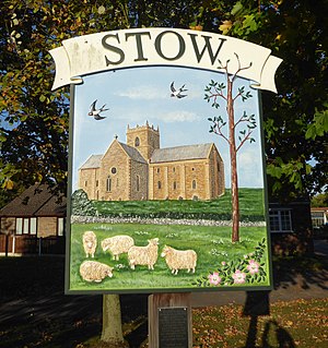
Stow is a small village and civil parish within the West Lindsey district of Lincolnshire, England. It is 11 miles (18 km) north-west of the city of Lincoln and 6 miles (10 km) south-east of Gainsborough, and lies along the B1241 road. The total resident population was 355 at the 2001 census, increasing to 365 at the 2011 census.
The Kings of Wessex Academy, formerly known as The Kings of Wessex School, is a coeducational secondary school located in Cheddar, Somerset, England. As of 2015, it has 1,176 students aged 13 to 18, of all genders and all ability levels including 333 in the sixth form. In November 2016, the academy became part of the Wessex Learning Trust which incorporates eight academies from the surrounding area. Kings is a Church of England school.

Wedmore is a large village and civil parish in the county of Somerset, England. It is situated on raised ground, in the Somerset Levels between the River Axe and River Brue, often called the Isle of Wedmore. It forms part of Sedgemoor district. The parish consists of three main villages: Wedmore, Blackford and Theale, with the 17 hamlets of Bagley, Blakeway, Clewer, Crickham, Cocklake, Heath House, Latcham, Little Ireland, Middle Stoughton, Mudgley, Panborough, Sand, Stoughton Cross, Washbrook, West End, West Ham and West Stoughton. The parish of Wedmore has a population of 3,318 according to the 2011 census.
York had around forty-five parish churches in 1300. Twenty survive, in whole or in part, a number surpassed in England only by Norwich, and twelve are currently used for worship. This article consists of, first, a list of medieval churches which still exist in whole or in part, and, second, a list of medieval churches which are known to have existed in the past but have been completely demolished.
Iscalis was a Roman settlement described by Ptolemy. The exact location has not been clearly identified but the possible sites are in the modern ceremonial county of Somerset, England.

Taunton Castle is a castle built to defend the town of Taunton, Somerset, England. It has origins in the Anglo Saxon period and was later the site of a priory. The Normans then built a stone structured castle, which belonged to the Bishops of Winchester. The current heavily reconstructed buildings are the inner ward, which now houses the Museum of Somerset and the Somerset Military Museum. The building was designated a grade I listed building in 1952.
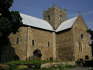
The Minster Church of St Mary, Stow in Lindsey, is a major Anglo-Saxon church in Lincolnshire and is one of the largest and oldest parish church buildings in England. It has been claimed that the Minster originally served as the cathedral church of the diocese of Lindsey, founded in the 7th century and is sometimes referred to as the "Mother Church of Lincolnshire".

South Petherton is a village and civil parish in the South Somerset district of Somerset, England, located 5 miles (8 km) east of Ilminster and 5 miles (8 km) north of Crewkerne. The parish had a population of 3,367 in 2011 and includes the smaller village of Over Stratton and the hamlets of Compton Durville, Drayton, Wigborough and Yeabridge. The River Parrett forms the eastern boundary of the parish. The village is approximately 2 miles (3 km) from East Lambrook, Martock and Lopen.

The Cheddar Yeo is a small river in Somerset, England. Beneath the limestone of the Mendip Hills it forms the largest underground river system in Britain. After emerging into Cheddar Gorge it flows through the village of Cheddar, where it has been used in the past to power mills. From the Middle Ages until the 19th century the river had ports for seagoing vessels but is no longer navigable. Some of the water, which is of good quality, is diverted into Cheddar Reservoir to provide drinking water for Bristol.

St Oswald's Priory was founded by Æthelflæd, daughter of Alfred the Great, and her husband Æthelred, ealdorman of Mercia, in the late 880s or the 890s. It appears to have been an exact copy of the Old Minster, Winchester It is a Grade I listed building.
The Sumorsaete were an Anglo-Saxon group living in what is now Somerset, presumably around the town of Somerton. They are evidently the source of the county's name. The group may have been established as early as 577, when the Saxons conquered part of the area from the Britons, but they are not mentioned by name until 845. They may have been related to the obscure Glastening or Glestinga, who may be the source of the name Glastonbury.

Bath's city walls were a sequence of defensive structures built around the city of Bath in England. Roman in origin, then restored by the Anglo-Saxons, and later strengthened in the High medieval period, the walls formed a complete circuit, covering the historic core of the modern city, an area of approximately 23 acres (9.3 ha) including the Roman Baths and medieval Bath Abbey. In the present-day however, the walls have largely disappeared, though the route they took is evident from the street layout; one of the gates partially remains.

Teffont is a civil parish in the south of Wiltshire, England, consisting of the villages of Teffont Magna and Teffont Evias. It is in the Nadder valley, north of the river, about 10 miles (16 km) west of Salisbury. The parish was created in 1934 by combining the two Teffonts. The population taken at the 2011 census was 248.


