Related Research Articles

The North Eastern Province is one of the former provinces of Kenya. It had a land area of 127,358.5 km2, with its capital at Garissa. The North Eastern Province was carved out of the then Northern Frontier District (NFD) prior to independence.

Isiolo is a town in Isiolo County, of which it is the capital. It is located in the upper eastern region of Kenya and is geographically considered the center of the country Kenya. It lies 285 kilometers north of the capital Nairobi. The town grew around the local military camps. Much of the population consists of Borana and Ameru as well as minority groups including Turkana, Samburu, Somali among others. The town has an estimated population of 78,250, most of which live around the outskirts of the town. There has been a steady increase in the urban population in recent years, especially moving from as far as Moyale, Marsabit and Mandera. Isiolo town recently acquired status as a resort city cashing in on the popular Samburu and Shaba Game reserves, tourist destinations after Maasai Mara. Isiolo lies along the long A2 Road, leading towards Marsabit and Moyale much further north.
Laikipia County is one of the 47 counties of Kenya, located on the Equator in the former Rift Valley Province. Laikipia is a cosmopolitan county and is listed as county number 31. The county has two major urban centres: Nanyuki to the southeast, and Nyahururu to the southwest. Its county government headquarters town is Rumuruti.

Garba Tula and popularly nicknamed by the locals El Borte is a town in Isiolo County, Northern Kenya. The town has an urban population of about 5,500. In 2007 it was up-graded to a District status. But with the new administrative sub-divisions of Kenya, Garba Tula is a sub-county of Isiolo County, as well as an administrative ward.
Marsabit County is a county in Kenya, covering a surface area of 66,923.1 square kilometres. Marsabit is the second largest county by size in Kenya after Turkana county which has an area of 71,597.8 km2. Its capital is Marsabit and its largest town is Moyale. According to the 2019 census, the county had a population of 459,785. It is bordered to the North by Ethiopia, to the West by Turkana County to the South by Samburu County and Isiolo County, and to the East by Wajir County.
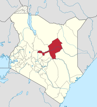
Isiolo County is a county in the former Eastern Province of Kenya. Its population was 268,002 according to 2019 census. The capital and largest town in the county is Isiolo. Isiolo County is set to be the first county to be developed as part of the Kenya Vision 2030 program. Other upcoming urban centres are: Garbatulla, Modogashe, Kinna, Merti and Oldonyiro. The county is home to Sakuye and Borana tribes and a significant number of people from Turkana, Samburu, Gabra, Garre and Meru communities.

Garissa County is a county in Kenya located in Eastern Kenya bordering Somalia to the East, Wajir County and Isiolo County to the North, Tana River County to the West, Lamu County to the South and the Indian ocean. Its capital and largest urban area is Garissa.

Wajir County is a county in the former North Eastern Province of Kenya. Its capital and largest town is Wajir. The county had a population of 781,263 during the 2019 Census. It has an area of 55,840.6 km2 (21,560.2 sq mi). The county is bordered to the north by Ethiopia, to the northeast by Mandera County, to the east by Somalia, to the south by Garissa County, to the west by Isiolo County and to the northwest by Marsabit County. The county has six constituencies: Wajir South, Tarbaj, Wajir North, Wajir West, Wajir East, and Eldas.
The Northern Frontier Province or Northern Province, or initially referred to as 'Northern Frontier District' (NFD) was one of the provinces of British Kenya. Originally, the Northern Frontier covered the northern region of East Africa Protectorate later succeeded by British Kenya, it later included half of the Jubaland Province that remained as part of Kenya when the other half was ceded to the Italian Empire.

The districts of Kenya were divided into 262 divisions (matarafa). Divisions of Kenya were further subdivided into locations. Today's counties of Kenya are based on the merging of some of the districts on this list and since the divisions are one level under the districts they are now the sub-counties. This is because Kenya recently changed its constitution and 47 Counties emerged. Here are the divisions listed below, by district :

The constituencies of Kenya are used to elect members of the National Assembly, the lower chamber of the Kenyan Parliament. In accordance with Article 89 of the 2010 Constitution of Kenya, there are 290 constituencies, based on a formula where these constituencies were to be delineated based on population numbers. Each constituency returns one Member of National Assembly. The constituencies are further divided into electoral wards.
Wamba is a small town in Samburu County in central Kenya. It is located south-southwest edge of the Mathews Range, and northwest of the Samburu National Reserve. The northbound Isiolo - Moyale road is about 40 kilometres drives east of Wamba.
Kenyan Somalis are citizens and residents of Kenya who are of Somali ethnic descent. They have historically inhabited the North Eastern Province, previously called the Northern Frontier District, which was carved out of the Jubaland region of present-day southern Somalia during the colonial period. Following the civil war in Somalia that broke out in 1991, many Somalis sought asylum in the Somali-inhabited enclaves of Kenya. An entrepreneurial community, they established themselves in the business sector, particularly in the Nairobi suburb of Eastleigh.
Sub-counties, formerly known as Districts, are the decentralised units through which government of Kenya provides functions and services. At national level, sub-counties take a more administrative function like security, statistical purposes, provision of government services, etc. Even though the sub-counties are divisions of counties, powers to create new national sub-counties lies with the national government. As of 2023, there are 314 sub-counties, compared to 290 constituencies. A deputy county commissioner is appointed by the state to lead each sub-county. The sub-counties are further divided into divisions, locations and sub-locations.
Samburu District was a district in the Rift Valley Province of Kenya. It covered an area of roughly 21,000 km2 (8,000 mi2) in northern Kenya where the Samburu tribe live. The district had a population of 143,547 in the 1999 census. It stretched north from the Wuaso Ng'iro River to the south of Lake Turkana and also includes Mount Kulal which lies just east of Lake Turkana.
Mandera District was an administrative district in the North Eastern Province of Kenya. Its capital town was Mandera. The district had an area of 26,744 km2.
Laikipia District was a district of Kenya, located on the Equator in the Rift Valley Province of the country. The district had two major urban centres: Nanyuki to the southeast, and Nyahururu to the southwest. Its capital was Nanyuki.
Kitui District was an administrative district in the Eastern Province of Kenya. Its capital was Kitui. The district had an area of 20,402 km2.
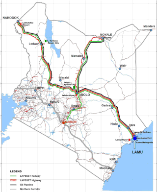
Lamu–Garissa–Isiolo Road, is a road in Kenya, and is part of the Lamu-Garissa-Isiolo-Lokichar Road, which itself is a component of the Lamu Port and Lamu-Southern Sudan-Ethiopia Transport Corridor (LAPSSET) Project.
Isiolo–Mandera Road, is a road in Kenya. It is a major transport route linking north-central Kenya to Kenya's northeast. The counties that the road traverses are generally arid, and have hitherto been undeserved. This road project is the largest and most expensive infrastructure project in northeastern Kenya since the country became independent in 1963.
References
- ↑ "Kenya Districts". www.statoids.com. Retrieved 2023-09-22.
- ↑ "description of the districts and provinces". Syracuse University. p. 5. Retrieved 30 September 2023.
- ↑ "Kenya Gazette dated 2nd April, 1963" (PDF). Gazettes.Africa. Retrieved 22 September 2023.
- ↑ "The 2009 Kenya Population and Housing Census" (PDF). Amazonaws. p. 84. Retrieved 28 September 2023.
- ↑ Boye, Saafo Roba; Kaarhus, Randi (2011-08-01). "Competing Claims and Contested Boundaries: Legitimating Land Rights in Isiolo District, Northern Kenya". Africa Spectrum. 46 (2): 99–124. doi: 10.1177/000203971104600204 . ISSN 0002-0397.
- ↑ "Isiolo District: Short Rains Assessment (February 2008) - Kenya | ReliefWeb". reliefweb.int. 2008-02-14. Retrieved 2023-09-30.
0°53′00″N38°40′00″E / 0.883333°N 38.6667°E
| | This Kenyan history-related article is a stub. You can help Wikipedia by expanding it. |