The Caribbean Sea is a sea of the Atlantic Ocean in the tropics of the Western Hemisphere. It is bounded by Mexico and Central America to the west and southwest, to the north by the Greater Antilles starting with Cuba, to the east by the Lesser Antilles, and to the south by the northern coast of South America. The Gulf of Mexico lies to the northwest.
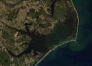
Pamlico Sound is a lagoon in North Carolina which is the largest lagoon along the North American East Coast, extending 80 mi (130 km) long and 15 to 20 miles wide. It is part of a large, interconnected network of lagoon estuaries that includes Albemarle Sound, Currituck Sound, Croatan Sound, Roanoke Sound, Pamlico Sound, Bogue Sound, Back Sound, and Core Sound. Together, these sounds, known as the Albemarle-Pamlico sound system, comprise the second largest estuary in the United States, covering over 3,000 sq. mi. (7,800 km2) of open water. The Pamlico Sound is separated from the Atlantic Ocean by the Outer Banks, a row of low, sandy barrier islands that include Cape Hatteras National Seashore, Cape Lookout National Seashore, and Pea Island National Wildlife Refuge. The Albemarle-Pamlico Sound is one of nineteen great waters recognized by the America's Great Waters Coalition.
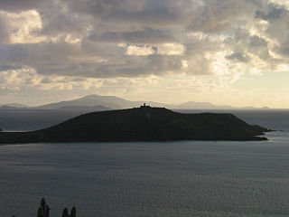
Isla Culebrita is a small, uninhabited island off the eastern coast of Culebra, Puerto Rico and is part of the Puerto Rico Archipielago. Together with Cayo Botella off the northwestern point, and Pelá and Pelaita to the west, it belongs to the barrio Fraile of Culebra. It is a nature reserve and is part of the Culebra National Wildlife Refuge. The island is home to Culebrita Lighthouse, one of the oldest lighthouses in the Caribbean. Culebrita is only accessible by private boat from the main island of Culebra.

The Federal Dependencies of Venezuela encompass most of Venezuela's offshore islands in the Caribbean Sea and the Gulf of Venezuela, excluding those islands that form the State of Nueva Esparta and some Caribbean coastal islands that are integrated with nearby states. These islands, with a total area of 342 square kilometres, are sparsely populated – according to the preliminary results of the 2011 Census only 2,155 people live there permanently, with another hundred from Margarita Island who live there seasonally to engage in fishing. Local government is officially under the authority of Central government in Caracas, although de facto power is often held by the heads of the sparse and somewhat isolated communities that decorate the territories.

The Mesoamerican Barrier Reef System (MBRS), also popularly known as the Great Mayan Reef or Great Maya Reef, is a marine region that stretches over 1,126 kilometres (700 mi) along the coasts of four countries – Mexico, Belize, Guatemala, and Honduras – from Isla Contoy at the northern tip of the Yucatán Peninsula south to Belize, Guatemala and the Bay Islands of Honduras. The reef system includes various protected areas and parks including the Belize Barrier Reef, Arrecifes de Cozumel National Park, Hol Chan Marine Reserve (Belize), Sian Ka'an biosphere reserve, and the Cayos Cochinos Marine Park. Belize's coastline, including the Belize Barrier Reef, is home to approximately 30% of the Mesoamerican Barrier Reef System.
The Gulf of Mannar Marine National Park is a protected area of India consisting of 21 small islands (islets) and adjacent coral reefs in the Gulf of Mannar in the Indian Ocean. It lies 1 to 10 km away from the east coast of Tamil Nadu, India for 160 km between Thoothukudi (Tuticorin) and Dhanushkodi. It is the core area of the Gulf of Mannar Biosphere Reserve which includes a 10 km buffer zone around the park, including the populated coastal area. The park has a high diversity of plants and animals in its marine, intertidal and near shore habitats. Public access inside the park is limited to glass-bottom boat rides. It was established as a National Park in 1986.

Caño Island is a small island and biological reserve in the Bahia de Corcovado in Osa, Costa Rica. It is on the Pacific Ocean side of Costa Rica, 10 miles (16 km) west of Punta Llorona on Península de Osa. It rises steeply to a flat top of 123 metres (404 ft) in height.

Marine National Park in the Gulf of Kutch is situated on the southern shore of the Gulf of Kutch in the Devbhumi Dwarka district of Gujarat state, India. In 1980, an area of 270 km2 from Okha to Jodiya was declared Marine Sanctuary. Later, in 1982, a core area of 110 km2 was declared Marine National Park under the provisions of the Wildlife (protection) Act, 1972 of India. There are 42 islands on the Jamnagar coast in the Marine National Park, most of them surrounded by reefs. The best-known island is Pirotan.It is located just adjacent to Indianoil COT at Vadinar. Many people working at Indianoil are certified guide at the park.
Buck Island National Wildlife Refuge is located about 2 miles (4 km) south of the island of St. Thomas in the Virgin Islands of the United States. Adjacent to the refuge is Capella Island, about half the size of Buck, owned by the territorial government. There is a second Buck Island just north of St. Croix that is the centerpiece of Buck Island Reef National Monument.

Pedasí is one of five districts of the Los Santos Province, Panama.

The wildlife of the Maldives includes the flora and fauna of the islands, reefs, and the surrounding ocean.

Wild Caribbean is a four-part BBC nature documentary series exploring the natural and cultural history of the Caribbean Islands and Sea. It was first transmitted in the UK on BBC Two in January 2007. The series was produced by the BBC Natural History Unit and narrated by actor Steve Toussaint. This series also aired in Australia on ABC1 each Sunday at 7:30pm from 15 February 2009.
Pedasí is a town and corregimiento situated on the south-eastern tip of the Azuero Peninsula on Panama’s Pacific coast. It is the capital of Pedasí District in Los Santos Province. Its population as of 1990 was 1,494; its population as of 2000 was 1,830. It had a population of 2,410 as of 2010. As of 1 July 2020 the population had grown to 4696.

The Gulf of Chiriquí National Marine Park is located in the Gulf of Chiriquí, on the Pacific coast of Panama. It was established in 1994 to protect 150 square kilometres (58 sq mi) of marine ecosystems, including coral reef, mangrove swamp and marine meadow, and around two dozen islands of the archipelago of Isla Parida. In total, the park has 25 islands and 19 coral reefs.

The fauna of the United States Virgin Islands consists of 144 species of birds, 22 species of mammals, 302 species of fish and 7 species of amphibians. The wildlife of the U.S.V.I. includes numerous endemic species of tropical birds, fish, and land reptiles as well as sea mammals. The only endemic land mammals are six species of native bats: the greater bulldog bat, Antillean fruit-eating bat, red fruit bat, Brazilian free-tailed bat, velvety free-tailed bat and the Jamaican fruit bat. Some of the nonnative land mammals roaming the islands are the white-tailed deer, small Asian mongoose, goats, feral donkeys, rats, mice, sheep, hogs, dogs and cats.

Solitary Islands Marine Park (SIMP) is a marine park in New South Wales State waters, Australia. It adjoins the Solitary Islands Marine Reserve and was declared under the Marine Parks Act 1997 (NSW) in January 1998. Prior to this it was declared a marine reserve in 1991. The Park was one of the first declared in NSW and stretches along the northern NSW coast, from Muttonbird Island, Coffs Harbour, to Plover Island near Sandon River, 75 kilometres to the north. It includes coastal estuaries and lakes and extends from the mean high water mark, to three nautical miles out to sea, covering an area of around 72 000 hectares. There are five main islands in the Park, North Solitary Island, North West Solitary Island, South West Solitary Island, South Solitary Island and Split Solitary Island, as well as other significant outcrops such as Muttonbird Island and submerged reefs.
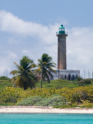
Petite Terre Islands National Nature Reserve is a reserve of the Petite Terre Islands in Guadeloupe. The reserve was established by Decree No. 98-801 of 3 September 1998 as the nature reserve for the islands of Petite Terre. It covers an area of about 990 hectares, which is demarcated by five points fixed with buoys, and includes a land area of 148.6 hectares with the balance as sea area.

The Gulf of Panama mangroves (NT1414) is an ecoregion along the Pacific coast of Panama and Colombia. The mangroves experience seasonal flooding with high levels of sediment, and occasional extreme storms or very low rainfall due to El Niño effects. They are important as a breeding or nursery area for marine species. Areas of the mangroves have been recognized as Important Bird Areas and Ramsar wetlands. The ecoregion has been severely degraded by clearance of mangroves for agriculture, pasturage and shrimp farming, by urban pressure around Panama City, and by pollution related to the Panama Canal.