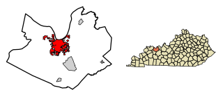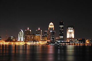
Louisville is the largest city in the Commonwealth of Kentucky and the 29th most-populous city in the United States. It is one of two cities in Kentucky designated as first-class, the other being Lexington, the state's second-largest city. Louisville is the historical seat and, since 2003, the nominal seat of Jefferson County, located in the northern region of the state, on the border with Indiana.

Kenton County is a county located in the Commonwealth of Kentucky. As of the 2010 census, the population was 159,720, making it the third most populous county in Kentucky. Its county seats are Covington and Independence. It was, until November 24, 2010, the only county in Kentucky to have two legally recognized county seats. The county was formed in 1840 and is named for Simon Kenton, a frontiersman notable in the early history of the state.

Jefferson County is a county located in the U.S. Commonwealth of Kentucky. As of the 2010 census, the population was 741,096. It is the most populous county in the commonwealth.

Barren County is a county located in the U.S. state of Kentucky. As of the 2010 census, the population was 42,173. Its county seat is Glasgow. The county was founded on December 20, 1798, from parts of Warren and Green Counties. It was named for the Barrens, meadow lands that cover the northern third, though actually the soil is fertile.

Owensboro is a home rule-class city in and the county seat of Daviess County, Kentucky, United States. It is the fourth-largest city in the state by population. Owensboro is located on U.S. Route 60 about 107 miles (172 km) southwest of Louisville, and is the principal city of the Owensboro metropolitan area. The 2015 population was 59,042. The metropolitan population was estimated at 116,506.

Jackson is a home rule-class city in and the county seat of Breathitt County, Kentucky, in the United States. The population was 2,231 according to the 2010 U.S. census.

The Louisville metropolitan area or Kentuckiana, also known as the Louisville–Jefferson County, Kentucky–Indiana, metropolitan statistical area, is the 45th largest metropolitan statistical area (MSA) in the United States. The principal city is Louisville, Kentucky.
The Kentucky Revised Statute 177.020(1) provides that the Department of Highways, a part of the Kentucky Transportation Cabinet, is responsible for the establishment and classification of a State Primary Road System which includes the state primary routes, interstate highways, parkways and toll roads, state secondary routes, rural secondary routes and supplemental roads. These routes are listed below.
Kentucky Route 80 (KY 80) is a 483.55-mile-long (778.20 km) state highway in the southern part of the U.S. state of Kentucky. The route originates on the state's western border at Columbus in Hickman County, and stretches across the southern portion of the state, terminating southeast of Elkhorn City on the Virginia state line. It is the longest Kentucky State Highway, though the official distance as listed in route logs is much less due to multiple concurrencies with U.S. Route 68 (US 68) and U.S. Route 23.

General Burnside Island State Park is a park located just south of Somerset, Kentucky in Pulaski County. The park encompasses 430 acres (170 ha) in the middle of Lake Cumberland, making it Kentucky's only island park. The park is named for General Ambrose E. Burnside, a Union general during the Civil War who stationed his troops at the location that the park now occupies.

Kentucky Route 90 is a major east-west state highway in southern Kentucky. The route is 134.734 miles (216.833 km) long, and it traverses Barren, Metcalfe, Cumberland, Clinton, Wayne, Pulaski, McCreary and Whitley Counties in southern Kentucky. It originates near the KY 70 junction with Interstate 65 in Cave City and ends at a junction with US 25W at Youngs Creek.
Kentucky Route 70 (KY 70) is a long east-east state highway that originates at a junction with U.S. Route 60 (US 60) in Smithland in Livingston County, just east of the Ohio River. The route continues through the counties of Crittenden, Caldwell, Hopkins, Muhlenberg, Butler, Edmonson, Barren, Barren, Metcalfe, Green, Taylor, Casey, Pulaski, Lincoln and back into Pulaski again to terminate at a junction with US 150 near Maretburg in Rockcastle.

Knox County is a county located near the southeastern corner of the U.S. state of Kentucky. As of the 2010 census, the population was 31,883. Its county seat is Barbourville. The county is named for General Henry Knox.
Kentucky Route 181 (KY 181) is a north–south state highway that traverses two counties in western Kentucky.

The Cincinnati metropolitan area, informally known as Greater Cincinnati or the Greater Cincinnati Tri-State Area, is a metropolitan area that includes counties in the U.S. states of Ohio, Kentucky, and Indiana around the Ohio city of Cincinnati. The United States Census Bureau's formal name for the area is the Cincinnati–Middletown, OH–KY–IN Metropolitan Statistical Area. As of the 2010 U.S. Census, this MSA had a population of 2,114,580, making Greater Cincinnati the 29th most populous metropolitan area in the United States, the first largest metro area entirely in Ohio, followed by Cleveland (2nd) and Columbus (3rd).


