
Clay County is a county located in the U.S. state of Kentucky. As of the 2020 census, the county population was 20,345. Its county seat is Manchester. The county was formed in 1807 and named in honor of Green Clay (1757–1826). Clay was a member of the Virginia and Kentucky State legislatures, first cousin once removed of Henry Clay, U.S. Senator from Kentucky and Secretary of State in the 19th century.

Owsley County is a county located in the Eastern Coalfield region of the U.S. state of Kentucky. As of the 2020 census, the population was 4,051, making it the second-least populous county in Kentucky. The county seat is Booneville. The county was organized on January 23, 1843, from Clay, Estill, and Breathitt counties and named for William Owsley (1782–1862), the judge of the Kentucky Court of Appeals and Governor of Kentucky (1844–48). According to the 2010 census reports, Owsley County has the second-highest level of child poverty of any county in the United States. In terms of income per household, the county is the poorest in the nation. Between 1980 and 2014, the rate of death from cancer in the county increased by 45.6 percent, the largest such increase of any county in the United States.
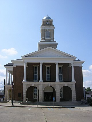
Garrard County is a county located east-central Kentucky. As of the 2020 census, the county's population was 16,953. Its county seat is Lancaster. The county was formed in 1796 and was named for James Garrard, Governor of Kentucky from 1796 to 1804. It is a prohibition or dry county, although its county seat, Lancaster, is wet. Lancaster was founded as a collection of log cabins in 1776 near a spring that later provided a constant source of water to early pioneers. It is one of the oldest cities in the Commonwealth. Boonesborough, 25 miles to the east, was founded by Daniel Boone in 1775. Lexington, 28 miles to the north, was founded in 1775. Stanford, originally known as St. Asaph, is 10 miles south of Lancaster. It too was founded in 1775. The oldest permanent settlement in Kentucky, Harrodsburg, was founded in 1774 and is 18 miles to the west. Garrard's present day courthouse is one of the oldest courthouses in Kentucky in continuous use.

Millersburg is a home rule-class city in Bourbon County, Kentucky, United States. The population was 792 at the 2010 census. It is part of the Lexington–Fayette Metropolitan Statistical Area.

Earle Bryan Combs was an American professional baseball player who played his entire career for the New York Yankees (1924–1935). Combs batted leadoff and played center field on the Yankees' fabled 1927 team. He is one of six players on that team who have been inducted into the Baseball Hall of Fame; the other five are Waite Hoyt, Herb Pennock, Tony Lazzeri, Lou Gehrig and Babe Ruth.
Cow Creek is an unincorporated community in Owsley County, Kentucky, United States, southeast of the county seat of Booneville. Wilson Edgar Terry lived there until 1927. Berniece T. Hiser was born there in 1908. Its post office closed in February 1957.

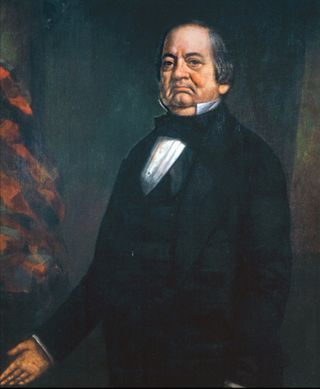
William Owsley was an associate justice of the Kentucky Court of Appeals and the 16th Governor of Kentucky. He also served in both houses of the Kentucky General Assembly and was Kentucky Secretary of State under Governor James Turner Morehead.
Robert Perkins Letcher was a politician and lawyer from the US state of Kentucky. He served as a U.S. Representative, Minister to Mexico, and the 15th Governor of Kentucky. He also served in the Kentucky General Assembly where he was Speaker of the House in 1837 and 1838. A strong supporter of the Whig Party, he was a friend of Henry Clay and John J. Crittenden.
Beaverlick is an unincorporated community in Boone County, Kentucky, United States. Beaverlick is located along U.S. Route 42 and U.S. Route 127 4.5 miles (7.2 km) west of Walton. The community was established as a fur trading site between 1780 and 1820. The community was founded sometime in the early 1800s. A post office was established at Beaver Lick in 1854 with John Tucker its postmaster. The post office closed in 1944.

Whoopflarea is an unincorporated community located in Owsley County, Kentucky, United States. Its post office closed in April 1954. Whoopflarea has been noted for its unusual place name.
Lucky Fork is an unincorporated community located in Owsley County, Kentucky, United States. Their Post Office no longer exists, it closed in June 1972.
Mistletoe is an unincorporated community located in Owsley County, Kentucky, United States. Its post office closed in January 2004. The community was named for the mistletoe native to the area.
Sexton's Creek is a creek in Clay County, Kentucky that is a tributary of the South Fork Kentucky River in neighbouring Owsley County, Kentucky. It is 24 miles (39 km) long.
Sturgeon is an unincorporated community located in Owsley County, Kentucky, United States. Its post office closed in April 1966.
Conkling is an unincorporated community located in Owsley County, Kentucky, United States. Its post office closed in December 1972.
Travellers Rest is an unincorporated community located in Owsley County, Kentucky, United States. Their post office closed in June 1964.

Lamb is an unincorporated community located 1/2 mi. south of the Monroe-Barren County boundary line on Kentucky Route 249, and centered at its intersection with New Design Road and Jack Hunt Road, in Monroe County, Kentucky, United States.
Addison is an unincorporated community in Breckinridge County, Kentucky, United States. Addison is located on the Ohio River and Kentucky Route 144, 6.8 miles (10.9 km) north-northeast of Cloverport.

The 1860 United States presidential election in Kentucky took place on November 6, 1860, as part of the 1860 United States presidential election. Kentucky voters chose 12 representatives, or electors, to the Electoral College, who voted for president and vice president.
Collins Creek, also known as Collins Fork, is a creek that is a fork of Goose Creek in Knox County and Clay County, Kentucky. It is 19 miles (31 km) long; is named for its first settler James Collins, a salt maker and hunter; joins Goose just south of Garrard; and is paralleled by road and railway for most of its course.


