Isthmus Department

Last updated
Isthmus Department
Departamento del Istmo
1824–1831
Istmo in Gran Colombia (1824).svg
Isthmus Department (red) within Gran Colombia
Status Department of Gran Colombia
Capital Panamá
Religion
Roman Catholic
Government Federal republic
History 
 Established
1824
 Disestablished
1831
Population
 1825 estimate
80,000
Currency Peso
Preceded by
Succeeded by
Blank.png Cundinamarca Department
Province of Panama (New Granada) Blank.png
Province of Veragua (New Granada) Blank.png
Mosquito Coast (New Granada) Blank.png
Today part ofPanama, parts of Costa Rica and Nicaragua

The Department of the Isthmus (Spanish: Departamento del Istmo, also known as the Isthmus Department or Department of Panama) was one of the departments of the Republic of Gran Colombia. It was created in 1824 and named after the Isthmus of Panama. It covered the territory of what is now the country of Panama and some disputed coastal territories farther northward along the Caribbean shoreline of present-day Costa Rica and Nicaragua (Mosquito Coast).

Contents

After the Thousand Days' War and the influence of the United States to build the Panama Canal the former Department of Gran Colombia separated from Colombia and became the Republic of Panama.

History

The region of Panama was part of the Spanish Empire during the wars of independence against the Spanish. On November 28, 1821, Panama proclaimed its independence from Spain. Independence was achieved without bloodshed and with the participation of the most prominent men of the country, who through their financial contributions neutralized the Spanish army that guarded the Isthmus. Panama's independence movement began on November 10, 1821 with the independence of the Villa de Los Santos  [ es ] led by Segundo Villarreal; eighteen days later, on November 28, after the patriot victory at the Battle of Carabobo, there was emancipation from the Spanish Empire and Panama's decision to voluntarily join Gran Colombia was officially proclaimed. [1]

Several factors influenced the final decision to join Panama to Gran Colombia, instead of Peru, its main trading partner during the Spanish colonial era. Of these, the most important to join Gran Colombia was the figure of Simón Bolívar, who at that time was at the height of his glory and popularity. [2]

Up until this point, Panama had remained within the Spanish monarchy and had avoided the troubles afflicting the rest of the Viceroyalty of New Granada. On November 28, 1821 Panama was voluntarily annexed to Gran Colombia under the Constitution of Cúcuta, which had been promulgated on August 30, 1819. On February 9, 1822, by Executive Decree of the Vice President of Gran Colombia, Francisco de Paula Santander, the Isthmus Department was provisionally created until the next meeting of Congress, with the same rights granted to the original departments created by the law of October 2, 1821. [3] He also divided it into two provinces: Panamá and Veraguas.

The Isthmus was characterized by a strong tendency towards autonomism, as an early antecedent we have the tenacious opposition of its political class, against the adoption of the Bolivian constitution that was intended to be implemented in Gran Colombia, despite all the efforts of the special envoy of Simón Bolívar and the pressure exerted by the intendant and military chief in the Isthmus.

In 1826, the same year in which the Isthmus rejected the Bolivian constitution, the Congress of Panama was held in the capital of the department. But this remarkable event was not an obstacle for the first attempt of separation from Colombia to take place in that year. It so happened that the Congress of Colombia ignored the requests for commercial franchises for the Isthmus, which frustrated Panamanian aspirations. Consequently, a separatist movement arose to turn Panama into a Hanseatic country, under the protection of the United Kingdom and the United States. The movement was, however, repressed by the Colombian military stationed on the Isthmus. [4]

Regarding concrete separations, the first was carried out under the leadership of General José Domingo Espinar  [ es ], who separated the Isthmus on September 26, 1830. However, he returned to reintegrate it to Gran Colombia on December 11 of the same year. The second attempt was made by Colonel Juan Eligio Alzuru  [ es ] on July 9, 1831, following the example of Venezuela and Ecuador. But the movement was suffocated and its leaders executed on August 29 of that year by orders of General Tomás de Herrera. [2]

Administrative divisions

Map of the Isthmus Department from 1827 Carta del Departamento del Istmo.jpg
Map of the Isthmus Department from 1827

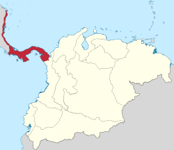
The department of the Isthmus was constituted with the territory of the current Republic of Panama, the north of the current department of Chocó, and the Costa Rican southern Pacific (from Punta Burica to the Golfo Dulce). In 1824, by means of the Law of Territorial Division of the Republic of Colombia [ es], the department was subdivided into provinces. According to the laws of Gran Colombia, the civil government of the department was headed by an intendant and the military authority was represented by the General Commander of the department.

According to the provisions of the Law of Division of Colombia of June 25, 1824, the department consisted of two provinces and 10 cantons:

Outside of these provinces, it also notionally included coastal territories farther northward along the Caribbean shoreline of present-day Costa Rica and Nicaragua. Control over this part of the Mosquito Coast was disputed with the British and the Federal Republic of Central America.[ citation needed ]

Related Research Articles

<span class="mw-page-title-main">History of Panama</span>

The history of Panama includes the history of the Isthmus of Panama prior to European colonization.

<span class="mw-page-title-main">Darién Province</span> Province of Panama

Darién is a province in Panama whose capital city is La Palma. With an area of 11,896.5 km2 (4,593.3 sq mi), it is located at the eastern end of the country and bordered to the north by the province of Panamá and the region of Kuna Yala. To the south, it is bordered by the Pacific Ocean and Colombia. To the east, it borders Colombia; to the west, it borders the Pacific Ocean and the province of Panama.

<span class="mw-page-title-main">Departments of Colombia</span> National subdivisions in Colombia

Departments of Colombia refer to the administrative divisions of Colombia. As of 2024, the unitary republic is made up of thirty-two departments. Each department has a governor and an assembly, elected by popular vote for a four-year period.

<span class="mw-page-title-main">Herrera Province</span> Province of Panama

Herrera is a province in Panama. Named after General Tomás Herrera, the province was founded on January 18, 1915 from a division of the Los Santos province. The capital city of Herrera is Chitré, which is located near the province's coastline. Herrera is bordered on the north by the provinces of Veraguas and Coclé, on the south by the province of Los Santos, on the east by Golfo de Parita and the province of Los Santos, and on the west by the province of Veraguas.

<span class="mw-page-title-main">Province of Tierra Firme</span> Spains New World Empire coastal possessions surrounding the Caribbean Sea and Gulf of Mexico

During Spain's New World Empire, its mainland coastal possessions surrounding the Caribbean Sea and the Gulf of Mexico were referred to collectively as the Spanish Main. The southern portion of these coastal possessions were known as the Province of Tierra Firme, or the "Mainland Province". The Province of Tierra Firme, or simply Tierra Firme, was also called Costa Firme.

<span class="mw-page-title-main">Santiago de Veraguas</span> City in Veraguas, Panama

Santiago de Veraguas is the capital of the province of Veraguas, in the Republic of Panama, and the district or municipality of the same name. Located in the countryside next to the Pan American Highway. Bounded on the north by San Francisco District, south by the District of Montijo, east by the District of Atalaya and west by the District of La Mesa. It has a population of approximately 60,000 inhabitants according to the data of the last census carried out in the Republic of Panama (2014).

Veragua or Veraguas was the name of five Spanish colonial territorial entities in Central America, beginning in the 16th century during the Spanish colonization of the Americas.

<span class="mw-page-title-main">Gran Colombia</span> Republic in South and Central America from 1819 to 1831

Gran Colombia, or Greater Colombia, officially the Republic of Colombia, was a state that encompassed much of northern South America and part of southern Central America from 1819 to 1831. It included present-day Colombia, mainland Ecuador, Panama, and Venezuela, along with parts of northern Peru, northwestern Brazil, and claimed the Essequibo region. The terms Gran Colombia and Greater Colombia are used historiographically to distinguish it from the current Republic of Colombia, which is also the official name of the former state.

<span class="mw-page-title-main">Real Audiencia of Quito</span> Administrative region of the Spanish Empire in northwestern South America (1563-1822)

The Real Audiencia of Quito was an administrative unit in the Spanish Empire which had political, military, and religious jurisdiction over territories that today include Ecuador, parts of northern Peru, parts of southern Colombia and parts of northern Brazil. It was created by Royal Decree on 29 August 1563 by Philip II of Spain in the city of Guadalajara. It ended in 1822 with the incorporation of the area into the Republic of Gran Colombia.

The constitutional history of Colombia is the process of formation and evolution of the different constitutions that Colombia has had since its formation.

<span class="mw-page-title-main">Separation of Panama from Colombia</span> 1903 French- and US-supported establishment of the Republic of Panama

The separation of Panama from Colombia was formalized on 3 November 1903, with the establishment of the Republic of Panama. From the Independence of Panama from Spain in 1821, Panama had simultaneously declared independence from Spain and joined itself to the confederation of Gran Colombia through the Independence Act of Panama. Panama was always tenuously connected to the rest of the country to the south, owing to its remoteness from the government in Bogotá and lack of a practical overland connection to the rest of Gran Colombia. In 1840–41, a short-lived independent republic was established under Tomás de Herrera. After rejoining Colombia following a 13-month independence, it remained a province which saw frequent rebellious flare-ups, notably the Panama crisis of 1885, which saw the intervention of the United States Navy, and a reaction by the Chilean Navy.

<span class="mw-page-title-main">History of Panama (to 1821)</span>

In the history of Panama, the earliest known inhabitants were the Cueva and Coclé tribes, but they were drastically reduced by disease and fighting when the Spanish arrived in the 16th century. But some moved out of Panama to have children and increase population.

The Republic of Gran Colombia was a former independent country in northern South America, a post-Spanish colonial country that existed from 1819 to 1831. Its initial subdivisions, created in 1820, were revised and expanded in 1824 to 12 departments.

The Royal Audience and Chancery of Panama in Tierra Firme was a governing body and superior court in the New World empire of Spain. The Audiencia of Panama was the third American audiencia after the ones of Santo Domingo and Mexico. It existed three times under various guises since it first creation in 1538 until its ultimate abolition in 1751.

<span class="mw-page-title-main">Panama State</span> 1855–1903 state of Colombia

The Panama State, officially known as the Federal State of Panama from 1855 to 1863, and as the Sovereign State of Panama from 1863 until 1886 when it was dissolved, was established as one of the states of the Republic of Gran Colombia established in 1821 after independence from the Spanish Empire and was later part of the Republic of New Granada, the Granadine Confederation, and the United States of Colombia. The state was established on 27 February 1855 and lasted until 1886 when it was replaced by the Department of Panama. In 1903, the territory of the Panama State achieved independence as the Republic of Panama.

<span class="mw-page-title-main">Bolivarian countries</span>

The Bolivarian countries are six Hispanic American countries whose republican origin is attributed to the ideals of Simón Bolívar and the independence war led by the Venezuelan military in the viceroyalties of New Granada and Peru.

<span class="mw-page-title-main">Independence Act of Panama</span>

The Declaration of Independence of Panama is the document through which Panama declared its independence from the Spanish Empire on November 28, 1821. It was proclaimed in the Cathedral Plaza of Panama City after a council of leaders had met and drafted twelve points calling for severing Panama's relationship with the Spanish Crown and joining with the newly formed Republic of Gran Colombia.

<span class="mw-page-title-main">Dissolution of Gran Colombia</span> Breakup of Gran Colombia

The dissolution of Gran Colombia and the disintegration of its political structures and central government created three independent countries: the Republic of Venezuela, the Republic of Ecuador and the Republic of New Granada.

<span class="mw-page-title-main">1827 Guayaquil uprising</span>

The 1827 Guayaquil uprising, also known as the Guayaquil Department rebellion, was a rejection of the centralist policies of Gran Colombia. This was one of the first separatist rebellions in the country of Gran Colombia before it dissolved in 1829.

References

  1. "Acta de fidelidad del Departamento del Istmo de Panamá a la República de Colombia". www.bicentenarios.es (in Spanish). Retrieved 2023-12-13.
  2. 1 2 "Contraloría de Panamá: Datos generales e históricos de la República de Panamá" (PDF). Archived (PDF) from the original on 2008-11-18.
  3. Juan B. Sosa, Límites de Panamá, 1919, Revista Loteria, Pág. 18-19.
  4. Quintero, César. Evolución Constitucional de Panamá. Editorial Portobelo, 1999. Panamá
  5. "Historia de Panama". Chiriqui.org. Archived from the original on 2008-09-14. Retrieved 2021-10-30.

See also

8°58′N79°32′W / 8.967°N 79.533°W / 8.967; -79.533