Itezhi-Tezhi Dam

Last updated
Itezhi-Tezhi Dam
Itezhi-Tezhi Lake.png
Zambia relief location map.jpg
Red pog.svg
Zambia
Location Itezhi-Tezhi, Zambia
Coordinates 15°45′55″S26°01′05″E / 15.76528°S 26.01806°E / -15.76528; 26.01806
Construction began1974
Opening date1977 (hydroelectric plant 2016)
Construction cost275,000,000 US$
Dam and spillways
Impounds Kafue River
Height62 m (203 ft)
Length1.8 km (1.1 mi)
Power Station
Commission dateFebruary 2016
Turbines 2 × 60 MW (80,000 hp)
Installed capacity 120 MW (160,000 hp)

The Itezhi-Tezhi Dam on the Kafue River in west-central Zambia was built between 1974 and 1977 at the Itezhi-Tezhi Gap, in a range of hills through which the river had eroded a narrow valley, leading to the broad expanse of the wetlands known as the Kafue Flats. The town of Itezhi-Tezhi is to the east side of the dam.

Contents

Dimensions and purpose

The dam has a height of 62 metres (203 ft), a crest length of 1,800 metres (5,900 ft) and forms a reservoir of 390 square kilometres (150 sq mi), flooding a section of the Kafue National Park.

The initial purpose of the dam is to store water for the Kafue Gorge Upper Power Station more than 260 kilometres (160 mi) downstream. The Kafue River, like most in south-central Africa, has a very high seasonal variation, flooding in the rainy season and slowing to perhaps a twentieth of the peak flow rate at the end of the dry season. Power generation however requires a steady flow, which can only be achieved by having a reservoir large enough to store the seasonal flood for use in the dry season. At the Kafue Gorge the topography does not allow a large enough reservoir to form. The designers of the dam therefore had the idea of siting the main reservoir at Itezhi-Tezhi, and releasing the water in a steady flow down the river along the Kafue Flats to the Kafue Gorge Dam. [1]

Power station

Construction began in 2011 of a 120 megawatts (160,000 hp) power station at the Itezhi-Tezhi Dam and was due for completion in 2015. The $250 million plant will be operated by Itezhi Tezhi Power Company (ITPC), a joint venture between ZESCO, the Zambian state-owned power company, and TATA Africa, a part of Indian conglomerate Tata Group. The engineering, procurement and construction (EPC) contractor is Sinohydro and two 60MW Kaplan turbines are being supplied by Alstom. [2]

In 2014, The African Development Bank (AfDB), the Dutch Development Bank FMO, the Development Bank of Southern Africa (DBSA) and Propaco of France provided the Zambian Government with a loan of $142 million to fund approximately half of the project cost. [3] The power station was fully commissioned in February 2016. [4]

Environmental impact of the dam on the Kafue River Flats

"Not all floods are unwanted"-- NASA. The eastern (lower) half of the Kafue Flats in the middle of the dry season, one year apart. Water shows as dark areas, the Kafue's main channel shows as the squiggle running left to right. In early 2004 the floodgates of the Itezhi-Tezhi Dam (about 80 km to the left of the photo) were opened to allow the natural flooding which used to happen before the dam was built. Compared to the previous year, much more of the flats remain inundated in the dry season and there is lot more vegetation (green colour). (Key: 1 Lusaka, 2 Kafue town, 3 Kafue Gorge Dam, 4, Mazabuka and Nakambala Sugar Estates, 5 Blue Lagoon National Park, 6 Lochinvar National Park, 7 Chunga Lagoon, 8 Kasenga.) Photo credit NASA/GSFC/LaRC/JPL, MISR Team. Eastern Kafue Flats in flood 2004.jpg
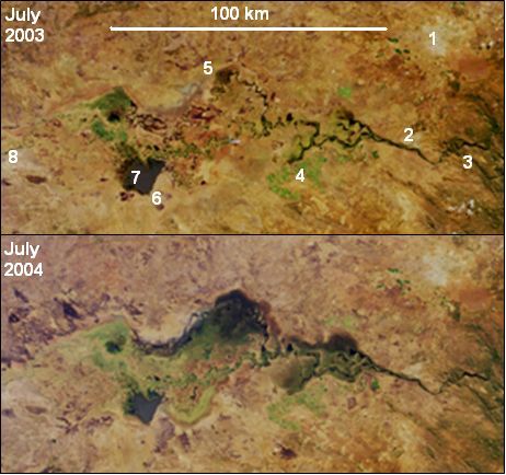
"Not all floods are unwanted"— NASA. The eastern (lower) half of the Kafue Flats in the middle of the dry season, one year apart. Water shows as dark areas, the Kafue's main channel shows as the squiggle running left to right. In early 2004 the floodgates of the Itezhi-Tezhi Dam (about 80 km to the left of the photo) were opened to allow the natural flooding which used to happen before the dam was built. Compared to the previous year, much more of the flats remain inundated in the dry season and there is lot more vegetation (green colour). (Key: 1 Lusaka, 2 Kafue town, 3 Kafue Gorge Dam, 4, Mazabuka and Nakambala Sugar Estates, 5 Blue Lagoon National Park, 6 Lochinvar National Park, 7 Chunga Lagoon, 8 Kasenga.) Photo credit NASA/GSFC/LaRC/JPL, MISR Team.

The Kafue Flats ecosystem is adapted to regular extremes of flooding and drying out. The floods charge the soil with water. Fish and animals adapt to swim or wade, help spread nutrients, and when the waters recede, grasses grow rapidly and sustain herbivores such as buffalo, lechwe, and cattle. The natural seasonal cycle has maintained plants, fish, and animals, as they have adapted to the March–April inundation in their nutrition and breeding. Many of the local residents move their settlements annually to cope with the regular cycle of flooding. [6]

The dam removes the peak of the flooding and the trough of low water in the dry season. It reduces the natural seasonal variation of the river flow. [7] The designers intended for the dam to 'open the floodgates' for the duration of March, and allow a flow of 300 m3/s to flood the Kafue Flats in order to maintain natural cycles. However, this has not happened in practice, mainly because the reservoir has not contained sufficient water at the right times to facilitate such a flow. The demand for electric power takes priority, and this, compounded by erratic rainfall since 1990, has prevented the dam from releasing water at the originally intended flow rates.

The Itezhi-Tezhi Dam has impacted the local ecology of the Kafue Flats in the following ways: [6]

The 2003/4 rainy season saw particularly high rainfall in Zambia. The effect of the Itezhi-Tezhi Dam release during this season is shown in the above NASA photos. According to a NASA website, in June 2004 an agreement was made with the hydroelectricity company to restore water releases from the dams according to a more natural flooding regime, presumably by keeping to the original intention of a 300 m3/s flood for the whole of March. [5]

Related Research Articles

<span class="mw-page-title-main">Kariba Dam</span> Dam in Zambia, Zimbabwe

The Kariba Dam is a double curvature concrete arch dam in the Kariba Gorge of the Zambezi river basin between Zambia and Zimbabwe. The dam stands 128 metres (420 ft) tall and 579 metres (1,900 ft) long. The dam forms Lake Kariba, which extends for 280 kilometres (170 mi) and holds 185 cubic kilometres (150,000,000 acre⋅ft) of water.

<span class="mw-page-title-main">Zambezi</span> Major river in southern Africa

The Zambezi is the fourth-longest river in Africa, the longest east-flowing river in Africa and the largest flowing into the Indian Ocean from Africa. Its drainage basin covers 1,390,000 km2 (540,000 sq mi), slightly less than half of the Nile's. The 2,574 km (1,599 mi) river rises in Zambia and flows through eastern Angola, along the north-eastern border of Namibia and the northern border of Botswana, then along the border between Zambia and Zimbabwe to Mozambique, where it crosses the country to empty into the Indian Ocean.

<span class="mw-page-title-main">Lechwe</span> Species of mammal

The lechwe, red lechwe, or southern lechwe is an antelope found in wetlands of south-central Africa.

<span class="mw-page-title-main">Luangwa River</span> River in Zambia

The Luangwa River is one of the major tributaries of the Zambezi River, and one of the four biggest rivers of Zambia. The river generally floods in the rainy season and then falls considerably in the dry season. It is one of the biggest unaltered rivers in Southern Africa and the 52,000 square kilometres (20,000 sq mi) that make up the surrounding valley are home to abundant wildlife.

<span class="mw-page-title-main">Kafue River</span> River in Zambia

The Kafue River is the longest river lying wholly within Zambia at about 1,576 kilometres (979 mi) long. Its water is used for irrigation and for hydroelectric power. It is the largest tributary of the Zambezi, and of Zambia's principal rivers, it is the most central and the most urban. More than 50% of Zambia's population live in the Kafue River Basin and of these around 65% are urban.

<span class="mw-page-title-main">Kafue</span> Town in Lusaka Province, Zambia

Kafue is a town on the T2 road in the Lusaka Province of Zambia and it lies on the north bank of the Kafue River, after which it is named. It is the southern gateway to the central Zambian plateau on which Lusaka and the mining towns of Kabwe and the Copperbelt are located.

<span class="mw-page-title-main">Kafue National Park</span> National Park in Zambia

Kafue National Park is the largest national park in Zambia, covering an area of about 22,400 km2. It is the second largest national park in Africa and is home to 152 different species of mammals. There are also 515 bird species, 70 reptile species, 58 species of fish and 36 amphibious species.

<span class="mw-page-title-main">Slaty egret</span> Species of bird

The slaty egret is a small, dark egret found in southern Africa. It is one of the species to which the Agreement on the Conservation of African-Eurasian Migratory Waterbirds (AEWA) applies. It is classified as Vulnerable, the biggest threat being habitat loss.

The Kafue Flats are a vast area of swamp, open lagoon and seasonally inundated flood-plain on the Kafue River in the Southern, Central and Lusaka provinces of Zambia. They are a shallow flood plain 240 km (150 mi) long and about 50 km (31 mi) wide, flooded to a depth of less than a meter in the rainy season, and drying out to a clayey black soil in the dry season.

<span class="mw-page-title-main">Lukanga Swamp</span> Major wetland in Zambia

Lukanga Swamp is a major wetland in the Central Province of Zambia, about 50 km west of Kabwe. Its permanently swampy area consists of a roughly circular area with a diameter of 40 to 50 km covering 1850 km2, plus roughly 250 km2 in the mouths of and along rivers discharging into it such as the Lukanga River from the north-east, plus another 500 km2 either side of the Kafue River to the west and north-west, making 2600 km2 in total. It contains many lagoons such as Lake Chiposhye and Lake Suye but few large channels, and its average depth is only 1.5 m.

<span class="mw-page-title-main">Wildlife of Zambia</span>

The wildlife of Zambia refers to the natural flora and fauna of Zambia. This article provides an overview, and outline of the main wildlife areas or regions, and compact lists of animals focusing on prevalence and distribution in the country rather than on taxonomy. More specialized articles on particular groups are linked from here.

<span class="mw-page-title-main">Zambezian flooded grasslands</span> Flooded grassland ecoregion in Africa

The Zambezian flooded grasslands is an ecoregion of southern and eastern Africa that is rich in wildlife.

The biomes and ecoregions in the ecology of Zambia are described, listed and mapped here, following the World Wildlife Fund's classification scheme for terrestrial ecoregions, and the WWF freshwater ecoregion classification for rivers, lakes and wetlands. Zambia is in the Zambezian region of the Afrotropical biogeographic realm. Three terrestrial biomes are well represented in the country . The distribution of the biomes and ecoregions is governed mainly by the physical environment, especially climate.

<span class="mw-page-title-main">Barotse Floodplain</span> Major floodplain in Central Africa

The Barotse Floodplain, also known as the Bulozi Plain, Lyondo or the Zambezi Floodplain, is one of Africa's great wetlands, on the Zambezi River in the Western Province of Zambia. It is a designated Ramsar site, regarded as being of high conservation value.

Itezhi-Tezhi is a small town in the Southern Province of Zambia. It is the seat of the Itezhi-Tezhi District. It lies west of the town of Namwala on the border of the Kafue National Park.

<span class="mw-page-title-main">ZESCO</span> Zambian national electricity company

ZESCO is a state-owned power company in Zambia. It is Zambia's largest power company producing about 80% of the electricity consumed in the country. ZESCO represents Zambia in the Southern African Power Pool.

The Kafue Gorge Upper Power Station (KGU), is an operational 900 megawatts (1,206,920 hp) hydroelectric power plant across the Kafue River in Zambia.

Kafue may refer to:

Julius Nyerere Hydropower Station is a hydroelectric dam under construction across the Rufiji River in eastern Tanzania. Although controversial, the government approved the plans in 2018. The power station is expected to have an installed capacity of 2,115 megawatts (2,836,000 hp) and to produce 5,920GWh of power annually. The project, power station and dam are owned by and will be managed by the government owned Tanzania Electric Supply Company (TANESCO). Construction began in 2019 and is expected to be completed in 2024.

Kafue Gorge Lower Power Station (KGL), is a 750 megawatts (1,010,000 hp) hydroelectric power station in Zambia.

References

  1. Zesco: "History of Itezhi-Tezhi" Archived 2005-09-07 at the Wayback Machine website accessed 1 March 2007.
  2. "Alstom wins bid for Zambia's Itezhi-Tezhi hydropower plant". Hydro World.
  3. "Zambia Signs Energy Sector Agreement for Itezhi Tezhi Power Generation Project". The African Development Bank.
  4. "JV commissions Itezhi Tezhi hydropower project, Zambia". Water Power & Dam Construction. Retrieved 11 February 2016.
  5. 1 2 NASA Visible Earth website: "Floodwaters Renew Zambia’s Kafue Wetland" Archived 2008-01-23 at the Wayback Machine Accessed 5 March 2007.
  6. 1 2 American Association for the Advancement of Science website Archived 2013-10-01 at the Wayback Machine : H N. Weza Chabwela & Wanga Mumba, "Integrating Water Conservation and Population Strategies on the Kafue Flats", Report of a Workshop on Water and Population Dynamics, Montreal, Canada, October 1996.
  7. FAO Fisheries Dept: "Status of fish stocks and fisheries of thirteen medium-sized African reservoirs" Website accessed 1 March 2007.