Indian or Indians refers to people or things related to India, or to the indigenous people of the Americas, or Aboriginal Australians until the 19th century.

Hurricane Ivan was a large, long-lived, Cape Verde hurricane that caused widespread damage in the Caribbean and United States. The cyclone was the ninth named storm, the sixth hurricane and the fourth major hurricane of the active 2004 Atlantic hurricane season. Ivan formed in early September, and reached Category 5 strength on the Saffir–Simpson Hurricane Scale (SSHS). Ivan caused catastrophic damage in Grenada as a strong Category 3 storm, heavy damage in Jamaica as a strong Category 4 storm, and then severe damage in Grand Cayman, Cayman Islands, and the western tip of Cuba as a Category 5 hurricane. After peaking in strength, the hurricane moved north-northwest across the Gulf of Mexico to strike Pensacola/Milton, Florida and Alabama as a strong Category 3 storm, causing significant damage. Ivan dropped heavy rain on the Southeastern United States as it progressed northeastward and eastward through the Eastern United States, becoming an extratropical cyclone on September 18. The remnant low of the storm moved into the western subtropical Atlantic and regenerated into a tropical cyclone on September 22, which then moved across Florida and the Gulf of Mexico, and then into Louisiana and Texas, causing minimal damage. Ivan degenerated into a remnant low on September 24, before dissipating on the next day. Ivan caused an estimated US$26.1 billion in damage along its path, of which $20.5 billion occurred in the United States.

Odd is an unincorporated community in Raleigh County, West Virginia, United States. It is located along Tommy Creek.

Emmons is an unincorporated community located on the Big Coal River in Boone and Kanawha counties in the U.S. state of West Virginia. Jay Rockefeller's political affiliation with West Virginia began in 1964-1965 while he served as a VISTA volunteer in Emmons.
The following is a set–index article, providing a list of lists, for the cities, towns and villages within the jurisdictional United States. It is divided, alphabetically, according to the state, territory, or district name in which they are located.

Quick is a small unincorporated community in Kanawha County, West Virginia, United States. It is located along Indian Creek Road. The community is where Whitoak Fork and Blue Creek come together and meet. It is also where the abandoned railroad that follows Blue Creek joins the road, and follows it all the way to the community of Hitop, along Pond Fork. Its post office is closed.

Belva is an unincorporated community and census-designated place in west Nicholas County and north Fayette County, West Virginia, United States; while the CDP only includes the Nicholas County portion, the Fayette County portion is considered part of the community. The town is situated at the bottomland surrounding the convergence of Bells Creek with Twentymile Creek and, subsequently, Twenty Mile Creek with the Gauley River. Belva is also the location of the convergence of two state highways: West Virginia Route 16 and West Virginia Route 39.

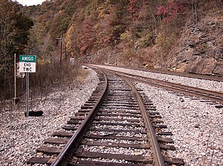
Amigo is an unincorporated community in Raleigh County, West Virginia, United States. The community is located on West Virginia Route 16 at the confluence of the Guyandotte River and Winding Gulf. The Amigo Post Office closed on 10/22/2011, it was established in 1915

Dickinson, also known as Quincy, is an unincorporated community in Kanawha County, West Virginia, United States. Dickinson is located on the north bank of the Kanawha River 3 miles (4.8 km) southeast of Belle. The community is served by U.S. Route 60.

Corton is an unincorporated community in Kanawha County, West Virginia, United States. Corton is located on the Elk River and West Virginia Route 4 4 miles (6.4 km) east of Clendenin.

Sanger is an unincorporated community in Fayette County, West Virginia.

Milburn is an unincorporated community and coal town in Fayette County, West Virginia, United States.

Olcott is an unincorporated community and coal town in Kanawha County, West Virginia, United States. Its post office is closed.

Wickham is an unincorporated community in Raleigh County, West Virginia, United States. Its post office is closed.

Dunloup or Dunloop is an unincorporated community and coal town in Fayette County, West Virginia.

Weir is an unincorporated community in Kanawha County, West Virginia, United States. Its post office is called Falling Rock.

Legg is an unincorporated community in Kanawha County, West Virginia, United States. Its post office is closed.

Rensford is an unincorporated community in Kanawha County, West Virginia, United States. Its post office is closed. It was also known as Point Lick.

Packs Branch is an unincorporated community in Fayette County, West Virginia.It was also called O'Neals.

Wevaco is an unincorporated community and former coal town in Kanawha County, West Virginia, United States. Its post office is closed.


