The abolition of the han system in the Empire of Japan and its replacement by a system of prefectures in 1871 was the culmination of the Meiji Restoration begun in 1868, the starting year of the Meiji period. Under the reform, all daimyos were required to return their authority to the Emperor Meiji and his house. The process was accomplished in several stages, resulting in a new centralized government of Meiji Japan and the replacement of the old feudal system with a new oligarchy.

Iwakura Tomomi was a Japanese statesman during the Bakumatsu and Meiji period. He was adopted by the influential Iwakura family, and became perhaps the single most influential leader of the nobility during Japan's transition from feudalism to modernity. By 1858 he was an advisor to the Emperor, but was exiled from the royal court from 1862 to 1867 for his moderation. After release he became the liaison between the court and the anti-Tokugawa movement. He played a central role in the new Meiji government after 1868. He successfully opposed aggressive policies in Korea in the crisis of 1873, and was nearly assassinated by his enemies. He led the 50-member Iwakura Mission for 18 months in Europe and America, studying modern institutions, technology, and diplomacy. The Mission promoted many key reforms that quickly modernized Japan. He promoted a strong imperial system along Western lines, and played a central role in creating financial institutions for the new nation. A 500 Yen banknote issued by the Bank of Japan carried his portrait.
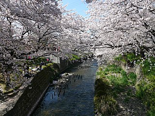
Iwakura is a city located in Aichi Prefecture, Japan. As of 1 October 2019, the city had an estimated population of 47,929 in 21,805 households, and a population density of 4,578 persons per km². The total area of the city was 10.47 square kilometres (4.04 sq mi). Iwakura city is famous for its "Cherry Blossom Festival" which mostly takes place around the end of March every year. Iwakura's cherry blossom is located at the symbol of the city "Gojo river" and lists as one of the top 100 best cherry blossom spots in Japan.

Urugi is a village located in Nagano Prefecture, Japan. As of 1 April 2019, the village had an estimated population of 552 in 274 households, and a population density of 13 persons per km². The total area of the village is 43.43 square kilometres (16.77 sq mi).

The Iwakura Mission or Iwakura Embassy was a Japanese diplomatic voyage to the United States and Europe conducted between 1871 and 1873 by leading statesmen and scholars of the Meiji period. It was not the only such mission, but it is the most well-known and possibly most significant in terms of its impact on the modernization of Japan after a long period of isolation from the West. The mission was first proposed by the influential Dutch missionary and engineer Guido Verbeck, based to some degree on the model of the Grand Embassy of Peter I.

The Tenryū River is a river in central Honshū, Japan. With a length of 213 km (132 mi), it is Japan's ninth longest river.

Hōnen'ike Dam is a multiple-arch dam in the Sanuki Mountain range at Kan'onji, Kagawa Prefecture, Japan. The reservoir it creates is used for irrigation. Construction began in 1926 and was completed in 1930. The dam is 32 m high and has a crest length of 158 m. It is supported by six arched buttresses. Some renovation work has been needed to control leakage; special care has been taken due to its status as a cultural asset.

Iwakura Station is a railway station in the city of Iwakura, Aichi Prefecture, Japan, operated by Meitetsu.

A yorishiro (依り代・依代・憑り代・憑代) in Shinto terminology is an object capable of attracting spirits called kami, thus giving them a physical space to occupy during religious ceremonies. Yorishiro are used during ceremonies to call the kami for worship. The word itself literally means "approach substitute". Once a yorishiro actually houses a kami, it is called a shintai. Ropes called shimenawa decorated with paper streamers called shide often surround yorishiro to make their sacredness manifest. Persons can play the same role as a yorishiro, and in that case are called yorimashi or kamigakari.
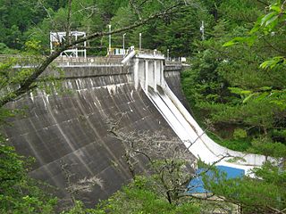
Iwakura Dam is a dam in Urugi, Nagano Prefecture, Japan, completed in 1936.

Lake Kutsuzawa Dam is a dam and lake in Shiojiri, Nagano Prefecture, Japan, completed in 1953.

The 1847 Nagano earthquake occurred at about 21:30 local time on 8 May at Nagano, Japan. It had a magnitude of 7.4 on the surface wave magnitude scale. It caused the destruction of many houses in Nagano and at least 8,600 people were killed. The earthquake triggered many landslides, the largest of which dammed the Sai River. 19 days later, the failure of this earthquake dam caused a flood that destroyed many more houses and killed 35 people.
Kogo-ike is an earthen dam located in Saga prefecture in Japan. The dam is used for agriculture. The dam impounds about 5 ha of land when full and can store 317 thousand cubic meters of water. The construction of the dam was completed in 1948.
Imago-ike Dam is an earthfill dam located in Shiga prefecture in Japan. The dam is used for irrigation. The catchment area of the dam is 0.9 km2. The dam impounds about 1 ha of land when full and can store 110 thousand cubic meters of water. The construction of the dam was started on and completed in 1964.
Ohkuma-ike dam is an earthfill dam located in Shiga prefecture in Japan. The dam is used for irrigation. The catchment area of the dam is 0.2 km2. The dam impounds about ha of land when full and can store 20 thousand cubic meters of water. The construction of the dam was completed in 1920.
Tankai-ike dam is an earthfill dam located in Shiga prefecture in Japan. The dam is used for irrigation. The catchment area of the dam is 30 km2. The dam impounds about 12 ha of land when full and can store 1320 thousand cubic meters of water. The construction of the dam was completed in 1934.
Tongu-ike dam is an earthfill dam located in Shiga prefecture in Japan. The dam is used for irrigation. The catchment area of the dam is 0.9 km2. The dam impounds about 2 ha of land when full and can store 320 thousand cubic meters of water. The construction of the dam was completed in 1965.
Shinmamushidani-ike Dam is an earthfill dam located in Shimane prefecture in Japan. The dam is used for irrigation. The catchment area of the dam is 0.3 km2. The dam impounds about 1 ha of land when full and can store 99 thousand cubic meters of water. The construction of the dam was completed in 1949.
Misaka-ike Dam is a gravity dam located in Tokushima prefecture in Japan. The dam is used for flood control and irrigation. The catchment area of the dam is 24.2 km2. The dam impounds about 2 ha of land when full and can store 55 thousand cubic meters of water. The construction of the dam was completed in 1946.