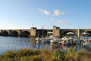
The rerouted I-195 in downtown Providence runs over the newly completed bridge at bottom, further away from the downtown core. The missing section of the old I-195, right of the Providence River, marks the beginning of the previous highway's demolition.
The project freed up space in downtown Providence and the Jewelry District. It involved renovating India Point Park and constructing a 50-foot-wide (15m)pedestrian bridge;[2] building a signature arch bridge over the Providence River; and improved highway flow, access, and safety, as the existing intersection was not built for modern traffic standards. The previous lane alignment was dangerous and created congestion, as lane shifts were often required to avoid a left sided exit-only lane; moreover, the concrete supports had deteriorated to the point that steel shoring are needed to reinforce the intersection's many bridges.[3]
History
Providence River with Fox Point Hurricane Barrier. The Providence River bridge is just downstream, but not connected to the barrier. The Manchester Street Power Station is on the right.The view of the bridge from the east bound lanes facing westThe west view of the approach ramps for I-195 (left) and the current right of way for 195 West
Back in the 1980s, RIDOT reviewed many plans to deal with the aging section of I-195 in Providence, which was built in the 1950s. Along with having to complete numerous repairs on one of the busiest stretches of highway in Rhode Island, traffic volumes had increased tremendously over the years. The highway designed for 75,000 vehicles a day now carries more than 160,000 cars daily.
The old design had other problems. Tight curves, left-hand exits and closely spaced exits had contributed to excessive congestion on the highway, which spilled over onto adjacent highways, causing delays for motorists on I-95, the Route 6/10 connector, and on city streets.
As RIDOT worked on the Iway’s Environmental Impact Statement (EIS) in the early 1990s, the highway’s problems were put to paper. The EIS noted deteriorated bridges, substandard roadway alignments, sharp curves and substandard shoulder widths. During the initial stages of the project, DOT worked on a joint project between the School of Architecture at ETH Zürich, and the Rhode Island School of Design (RISD), Providence, Rhode Island to include studies of the Iway in their "Project Providence", an exploration of the city through computer visualization.
RIDOT looked at three alternatives before choosing the one that was built. An alignment just to the north of the current highway was not selected as it would have corrected only the congestion and tight curves on I-195 itself. It would not have dealt with the weaving motorists face due to closely spaced exits at the highway interchange, nor would it have addressed better access to the Eddy Street hospitals campus, and it would have created only limited opportunities for redevelopment as outlined in the Old Harbor Plan. The plan outlines how the land occupied by the existing highway will be reused.
Another idea that was considered was a no-build alternative, one in which the existing alignment would be reconstructed. This would have addressed problems with deteriorated structures, but done nothing about the congestion, weaving conflicts and existing safety hazards. Additionally, traffic would have been severely impacted during construction.
Consideration of these choices led RIDOT to choose the alignment south of the Fox Point Hurricane Barrier. Safety problems and congestion issues could be addressed, and the removal of the old highway would allow for significant redevelopment of the Providence waterfront and fuller implementation of the Old Harbor Plan. Also, the redevelopment would complement other projects including the construction of Memorial Boulevard, Waterplace Park and the Riverwalk system, and the Capital Center projects.
Roadway openings and closings
On November 4, 2007, the new Iway bridge opened to eastbound traffic from I-95 north to I-195 east. Old exit 20 from I-95 north to I-195 east remained open for access to I-195 exits 1 and 2. I-195 exit 3 eastbound (Gano St.) became accessible from new Iway bridge only. Five days later, a new onramp from Wickenden and Point Streets to I-195 east opened, and the old onramp closed. On May 19, 2008, a temporary onramp to I-195 east from Hoppin street opened, and on May 22, 2008, the eastbound Exit 3 offramp to Gano street closed, while a new eastbound Exit 2 opened from Iway bridge to India Point/Gano Street/Wickenden Street. On May 27, 2008, the Friendship Street onramp to I-195 east closed, followed by the closure of the I-95 north exit 20 to old I-195 east, two days later.
On June 13, 2008, the Pine Street overpass over I-95 closed. On October 15, 2008, the New India Point Park pedestrian bridge over I-195 opened, and on October 29, 2008, a temporary ramp opened from Blackstone Street to I-95 south. On November 7, 2008, the onramp from Broad Street to I-95 south closed. By December 6, 2008, the new exit 20 from I-95 south to the new I-195 east opened, and the new onramp from Plain Street to I-195 east also opened. Then, the old I-195 eastbound roadway was closed, including all on and off ramps from old I-195 eastbound.
On June 18, 2009, the new Iway bridge opened to westbound I-195 traffic to I-95 south, while the old I-195 west remained open to funnel traffic to I-95 north. All ramps to/from old I-195 west also remained open. On October 20, 2009, the new Exit 20 from I-95 NB to Point Street opened, and two days later, the new ramps from the Iway bridge to I-95 north and Point Street (Exit 1A) opened. All I-195 west traffic was now using the new highway and the old I-195, and all remaining on-ramps to it, were closed completely. I-195 WB Exit 2 (South Main St) remained open, however.
On October 13, 2010, the new Clifford Street bridge over I-95 opened, as well as the new entrance ramp to I-95 NB from Point Street. Two weeks later, on October 19, the new exit 19 ramp from I-95 SB to Borden and Eddy Streets opened, while the old exit 19 ramp remained open temporarily. Demolition of the old right of way started on November 15, 2010, and was completed in September 2011. On October 3, 2011, the last major ramp of the project, the new ramp from I-195 West to the R.I. Hospital area, opened.
Traffic response
The first few days of the Iway being opened caused lengthy delays for motorists on I-95 South to I-195 East. This was alleviated by several steps RIDOT took. These included combining two on-ramps into one at their merge point with I-195 East, making minor lane adjustments, and a public education campaign to encourage people to get onto I-95 North and then the Iway as opposed to using exits on the old stretch of I-195 where backups were occurring. These changes shifted traffic to the Iway which had excess capacity. In three days traffic was reduced to original evening congestion levels. By the end of the week, congestion had lessened from original levels.[4]
The opening of the Iway ramp has eased congestion on I-95 North during the afternoon commute. Originally traffic backed up each evening for approximately 2.2 miles (3.5km). Long traffic backups on this part of I-95 North are unusual except in times of adverse weather or accidents.
Iway Bridge Float
A significant milestone was the floating of the new Providence River Bridge from the Quonset Business Park to its final resting place in Providence. In August 2006, RIDOT orchestrated a series of events to install the 400-foot (120m) center span for the bridge. The bridge float captured the attention of Rhode Islanders from all over the state who watched on television and read in newspapers about the entire process of raising the bridge, placing it on Self-Propelled Modular Transporters (SPMTs), rolling it onto two large barges, and floating it up the Bay. The day of the float, thousands of people lined the shores of the Bay to witness history and watch the bridge sail by. The bridge float also attracted the attention of the History Channel, which produced a documentary on the Iway for its “Mega Movers” series.
The following is a timeline of the Providence River Bridge construction and float:
October 2005: Work began on the center span at Pier 2 in the Davisville section of the Quonset Business Park (QBP) in North Kingstown, R.I. March 2006: Cardi Corporation (lead contractor) completed construction of center span. August 11, 2006: Kickoff event for dignitaries and media held at Davisville Pier 2. August 21, 2006: Bridge lifted to a height of 30 feet (9.1m), followed by placement of SPMTs. August 25, 2006: Bridge rolled to edge of Pier 2. August 26, 2006: Bridge loaded onto barges and secured for sea voyage. August 27, 2006: Bridge leaves QBP for Providence. Barges make nearly twice the expected speed and arrive two hours ahead of schedule. August 28, 2006: Bridge moved into position at new piers and lowered into place.
Opening-day ceremonies
The opening of the Iway was preceded by a public walk on the Iway on October 20, 2007. An estimated 10,000 people attended the event from 9 a.m. to noon. Visitors started lining up one hour before the event start time and RIDOT extended the event by about one hour. Visitors traveled to the site on RIPTA buses from one of two satellite parking locations in Providence, from the Johnson & Wales University Harborside Campus and from the State Offices campus. Once there they received a commemorative program[5] and walked the length of the new Providence River Bridge was well as approach ramps on both the east and west side of the bridge.
Awards
On June 9, 2008, RIDOT announced [6] that the Iway was nominated for a national award for the Iway bridge float. The competition, America's Transportation Award, is sponsored by the American Association of State Highway Transportation Officials (AASHTO), the U.S. Chamber of Commerce and AAA. The contest recognizes transportation projects completed on time, on budget or those that demonstrate innovative management. The latter category is the one RIDOT ran for. On August 13, AASHTO announced that the Iway bridge float was one of 10 finalists for the national award. The Iway bridge received an Innovative Management award in the large project category.[7]
On June 11, 2008, RIDOT was informed[8] that it was the recipient of a "Bell Ringer" award from the Publicity Club of New England. The award was for the Iway logo with its three arches and the tag line "Yours. Mine. Ours." The award is the highest achievement given by the annual competition, which is the region's premier public relations and communications event.
Light pollution
One of the key features of the Iway, the new Providence River Bridge, is illuminated by architectural lighting, making it visible from many points in the city and on the Providence River. There has been criticism[9] that this lighting has caused a considerable amount of light pollution. This has made it difficult for astronomers in the Providence area to view the night sky. Complaints have been made to the state and in response, lights are turned off at 11 p.m. to save energy and reduce light pollution.[citation needed]
Related Research Articles
State Route 60 is an east-west state highway in the U.S. state of California. It serves the cities and communities on the eastern side of the Los Angeles metropolitan area and runs along the south side of the San Gabriel Valley. It functions as a bypass route of Interstate 10 (I-10) through the area between the East Los Angeles Interchange in Los Angeles and Beaumont. SR 60 provides a route across several spurs of the Peninsular Ranges, linking the Los Angeles Basin with the Pomona Valley and San Gabriel Valley. The highway also overlaps at State Route 57 and Interstate 215.
Interstate 295 (I-295), sometimes called the Providence Beltway, is an auxiliary Interstate Highway in the U.S. states of Rhode Island and Massachusetts; it is maintained by the Rhode Island Department of Transportation (RIDOT) and the Massachusetts Department of Transportation (MassDOT). Spanning nearly 27 miles (43 km) it forms a western beltway around Providence, and is a bypass of I-95 as it travels through the capital city. I-895 was proposed as a complementary eastern beltway to complete a full loop around the city in the 1960s, but was ultimately scrapped in the 1980s.
Interstate 384 (I-384) is an Interstate Highway located entirely within the state of Connecticut. It runs 8.53 miles (13.73 km) east to west, going from I-84 and I-291 in East Hartford to U.S. Route 6 and U.S. Route 44 in Bolton.
Interstate 290 (I-290) is an auxiliary Interstate Highway that runs westwards from the Chicago Loop. The portion of I-290 from I-294 to its east end is officially called the Dwight D. Eisenhower Expressway. In short form, it is known as "the Ike" or the Eisenhower. Before being designated the Eisenhower Expressway, the highway was called the Congress Expressway because of the surface street that was located approximately in its path and onto which I-290 runs at its eastern terminus in the Chicago Loop.
Interstate 195 (I-195) is an Interstate Highway running a combined 44.23 miles (71.18 km) in the U.S. states of Rhode Island and Massachusetts. It travels from a junction with I-95 in Providence, Rhode Island, east to a junction with I-495 and Route 25 in Wareham, Massachusetts. It runs east–west and passes through the cities of Fall River, Massachusetts, and New Bedford, Massachusetts. The portion of I-195 in East Providence is also known as the East Providence Expressway.
Route 4, also known as the Colonel Rodman Highway, is a 10.37-mile-long (16.69 km) numbered state highway located in Washington County and southern Kent County, Rhode Island, United States. The route is a major north–south freeway in the southern Providence metropolitan area, directly linking Providence with eastern Washington County, the beaches of Narragansett and South Kingstown, and the city of Newport. Route 4 begins as a two-lane divided highway at an intersection with U.S. Route 1 in the town of North Kingstown, becoming a limited-access freeway after 1.89 miles (3.04 km). The route has four numbered interchanges before terminating in the city of Warwick, where the northbound lanes merge into Interstate 95 (I-95).
Route 10 is a numbered state highway connector in the U.S. state of Rhode Island, traveling along the Huntington Expressway, the first freeway in the state. It connects Route 12 on the Cranston–Providence city line with Interstate 95 (I-95), U.S. Route 6 (US 6), and Memorial Boulevard in downtown Providence, passing just east of the Olneyville area of Providence. It provides an alternate route to I-95 south of downtown, and connects it with the US 6 freeway west from Olneyville towards I-295 and Connecticut.
Route 37, also known as the Lincoln Avenue Freeway, is a state highway running 3.47 miles (5.58 km) in Providence County and Kent County, Rhode Island, United States. A freeway for its entire length, it serves the cities of Cranston and Warwick and is also a major east–west freeway in the Providence metropolitan area, linking T. F. Green Airport with Interstate 295. The western terminus of Route 37 is an at-grade intersection with Natick Avenue in Cranston. The freeway has numbered interchanges with I-295, Rhode Island Route 2, Pontiac Avenue, and I-95 before terminating at a trumpet interchange with U.S. Route 1 in Warwick.
Route 99, also known as the Woonsocket Industrial Highway, is a numbered state highway running 2.9 miles (4.7 km) in Providence County, Rhode Island, United States. The route is a nominally north–south limited-access freeway for its entire length. Route 99 serves Manville and the Highland Industrial Park, providing freeway access to the city of Woonsocket from Rhode Island Route 146, which bypasses the city. The southern terminus of Route 99 is at a partial interchange with Route 146 in Lincoln. The freeway has one interchange in Manville, a village in Lincoln, before terminating at an at-grade intersection with Rhode Island Route 122 in Woonsocket.
Route 103 is a numbered state highway running 11.8 miles (19.0 km) in Rhode Island, United States. It runs from Interstate 195 (I-195) in East Providence to the Massachusetts state line in the town of Warren, where the road continues as Massachusetts Route 103. Route 103 is a major commercial corridor in East Providence.
The Central Artery is a section of freeway in downtown Boston, Massachusetts; it is designated as Interstate 93, US 1 and Route 3.
U.S. Route 1A is the name of several highways found in the United States.
Route 146 is a limited-access road in the U.S. state of Rhode Island, maintained by the Rhode Island Department of Transportation (RIDOT). Spanning approximately 16 miles (26 km) along a north–south axis, it links the cities of Providence, Woonsocket, and Worcester, Massachusetts.
Route 403, also known as the Quonset Freeway, is a numbered state highway located in Washington County and Kent County, Rhode Island, United States. The route is a nominally east–west limited-access freeway for its entire length. A spur of Rhode Island Route 4, Route 403 serves Davisville and the Quonset Business Park, providing freeway access to Interstate 95 and the northern Providence metropolitan area from the industrial zone. The western terminus of the freeway is at a trumpet interchange with Route 4 in East Greenwich. The route has three unnumbered interchanges along its 4.5-mile (7.2 km) length, including a junction with U.S. Route 1 in North Kingstown, before terminating at an at-grade intersection with Roger Williams Way and Commerce Park Road in Quonset. Route 403 is the highest numbered route in Rhode Island.
The Connecticut Turnpike, officially the Governor John Davis Lodge Turnpike, is a controlled-access highway and former toll road in the U.S. state of Connecticut; it is maintained by the Connecticut Department of Transportation (ConnDOT). Spanning approximately 128 miles (206 km) along a generally west–east axis, its roadbed is shared with Interstate 95 (I-95) for 88 miles (142 km) from the New York state border in Greenwich to East Lyme; I-395 for 36 miles (58 km) from East Lyme to Plainfield; and State Road 695 (SR 695) for four miles (6.4 km) from Plainfield to the Rhode Island state line at U.S. Route 6 (US 6) in Killingly. The turnpike briefly runs concurrently with US 1 from Old Saybrook to Old Lyme and Route 2A from Montville to Norwich.
Interstate 95 (I-95) is the main north–south Interstate Highway on the east coast of the United States, running generally southwest-northeast through the U.S. state of Rhode Island. It runs from the border with Connecticut near Westerly, through Warwick and Providence, and to the Massachusetts state line in Pawtucket. It has two auxiliary routes, both of which enter Massachusetts—I-195: a spur from Providence east to Cape Cod, and I-295, a western bypass of the Providence-Pawtucket area.
The Washington Bridge is a series of three bridges carrying Interstate 195, US Route 6, US Route 44, and U.S. Route 1A over the Seekonk River connecting India Point in Providence to Watchemoket Square in East Providence, Rhode Island. The historic portion of the bridge dating to 1930 serves as the pedestrian crossing, and bike link to the East Bay Bike Path. The pedestrian span is also a part of the Washington-Rochambeau National Historic Trail.
U.S. Route 6 (US 6) is a major east–west road in the U.S. state of Rhode Island. Nationally, the route continues west to Bishop, California and east to Provincetown, Massachusetts. In western Rhode Island, it forms part of one of several routes between Hartford, Connecticut and Providence, Rhode Island, and was planned to be replaced by Interstate 84. The part of I-84 that was built, from Interstate 295 to Olneyville, is now part of US 6. At Olneyville, US 6 joins Route 10 and heads east towards downtown Providence, where it turns south on Interstate 95 and east on Interstate 195. US 6 splits from I-195 in East Providence, crossing into Massachusetts on Warren Avenue. The whole route of US 6 is a state highway maintained by the Rhode Island Department of Transportation.
U.S. Route 6 (US 6) in Massachusetts is a 117.95 mi (189.83 km) long portion of the cross-country highway connecting Providence, Rhode Island to Fall River, New Bedford, and Cape Cod. In the Fall River and New Bedford areas, US 6 is a secondary highway paralleling Interstate 195. On Cape Cod, US 6 is the primary highway interconnecting the towns of the area, similar to U.S. Route 1 in the Florida Keys. The expressway section in this area is also known as the Mid-Cape Highway. The route is also alternatively signed as the "Grand Army of the Republic Highway."
The Jewelry District is a neighborhood of Providence, Rhode Island located just south of Downtown between Interstate 195 and Henderson Street. Interstate 95 lies at the western edge of the neighborhood, which includes Davol Square and the waterfront along the west bank of the Providence River.
Iway videocasts - RIDOT released a series of videocasts beginning October 1, 2007, in which hosts explain stages in the project's completion
This page is based on this Wikipedia article Text is available under the CC BY-SA 4.0 license; additional terms may apply. Images, videos and audio are available under their respective licenses.