Sanag is an administrative region (gobol) in north eastern Somaliland. Sanaag has a long coastline facing the Gulf of Aden to the north, and is bordered by the region of Sahil to the west, Sool to the south and Somalia to the east. The region is disputed by the self-declared Republic of Somaliland and Puntland, a Federal Member State of Somalia. Its capital city is Erigavo. Sanaag is the largest region of Somaliland, accounting for 35% of Somaliland's total land area.
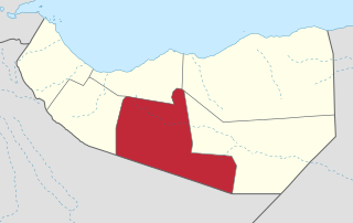
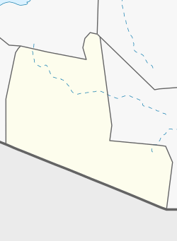
Togdheer is an administrative region (gobol) in central Somaliland. Togdheer is bordered by Maroodi Jeex to the west, Saaxil to the north, Sanaag to the northeast, Sool to the east and Ethiopia to the south. Its capital is Burao.

Nugal, traditionally known as Nugaaleed-Bari or Bari-Nugaal meaning eastern Nugaal, or Nugaal xaggeeda hoose meaning lower Nugaal, is an administrative region (gobol) in northern Somalia.
The Arap or Arab clan is a major Northern Somali clan of the wider Isaaq clan family. The Arap predominantly live on the middle and southwest side of Hargeisa and in the Baligubadle district Hawd region) of Somaliland, with its capital Baligubadle being an exclusively Arap territory. The territory of the clan extends to Ethiopia, in the area of Faafan, gursum, dhagahle. The Abdalle Arap, a sub-clan of the Arap clan is based in the Togdheer, Sahil. The Celi Arap, a sub-clan of the Arap clan is based in Maroodi Jeex Hargeisa Muuse celi arab living also Bakool South West State of Somalia Rabdhure Elbarde, And The Makaahiil Muse ( Afyare), A sub-clan that lives in Gumar, Balligubadle, And Hargeisa, They also live Fafan Zone Gursum, Somali. Sheekh cismaan sub-clan arab Gursum, Somali based in Nogob Zone Jarar Zone regions.
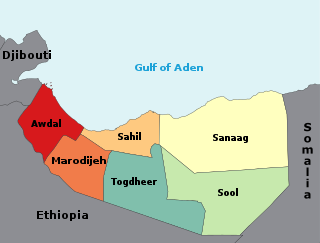
The regions of Somaliland is divided into six administrative regions, Awdal, Sahil, Maroodi-Jeeh, Togdheer, Sanaag and Sool. These are in turn subdivided into twenty-two districts. Regions of Somaliland are the primary geographical divisions through which Somaliland is administered. A distinction is made between districts of grades A, B, C and D, with the classification being based on population, area, economy and production.

Baligubadle is a town in the southern Maroodi Jeex region of Somaliland. The locality serves as the capital of the Baligubadle District, an administrative subdivision of the Maroodi Jeex region that was created in 1991 after regaining Somaliland independence, and straddles the border with the Somali Region of Ethiopia. The town has approximately 60,000 inhabitants.

Buuhoodle, also known as Bohotle, is the largest city in the Cayn region of Somalia. It serves as a significant border town for the movement of goods between Somalia and the Somali Region of Ethiopia. The surrounding district is rich in livestock with growing agricultural activities.
Burao District is a district of the Togdheer region in central Somaliland. Its capital lies at Burao.
Qorilugud is a sizeable town in Togdheer region of Somaliland, located north by road from Buuhoodle. It is the second-largest town in Buuhoodle District after the district capital Buuhoodle.
Widhwidh, also known as Widh Widh, is a town located in the Buuhoodle district of Togdheer, Somalia.

Sahdheer is a town in southern Sool region of Somalia.
Sahil is an administrative region (gobol) in northern Somaliland with the port city of Berbera as its capital. It was separated from Woqooyi Galbeed and became a province in 1991. In 1998, the Sheikh District of Togdheer was incorporated into Sahil region. The region has a long coastline facing the Gulf of Aden to the north. Sahil borders Awdal to the northwest, Maroodi Jeex to the southwest, Togdheer to the south and Sanaag to the east.
Dabaqabad, or Daba Qabad is a village in Burao District, in the Togdheer Region of Somaliland. It is located north by road from Balidhiig.
Beer is a village in Burao District, in the Togdheer region of Somaliland. It is located 30 kilometres (19 mi) south-east by road from Burao.
Odanleh, also spelt Odenleh is a town in Buhoodle District, in the Togdheer region of Somaliland.
Qalloocan, also spelt Qaloocan is a town in the Burao District, in the Togdheer region of Somaliland. It is inhabited by the Sanbuur sub-division of the Habr Je'lo Isaaq clan.
Godheeli, also spelt God Heeli is a town in the Aynabo District, in the Togdheer region of Somaliland.
Hahi, is a town in Oodweyne District located in western Togdheer, Somaliland.
Iskudar is a village in the Togdheer region of Somaliland. The closest airport is the Berbera Airport which is distanced 55 km from Iskudar.
Kirit is a town in the Burao District, in the Togdheer region of Somaliland. The town is 92 km southeast of Burao, the regional capital. It located on the road connecting Burao and Las Anod. It belonged to the Saraar region, which was temporarily established in Somaliland.