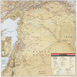
Syria is located in West Asia, north of the Arabian Peninsula, at the eastern end of the Mediterranean Sea. It is bordered by Turkey to the north, Lebanon and Israel to the west and southwest, Iraq to the east, and Jordan to the south. It consists of mountain ranges in the west and a steep area inland. In the east is the Syrian Desert and in the south is the Jabal al-Druze Range. The former is bisected by the Euphrates valley. A dam built in 1973 on the Euphrates created a reservoir named Lake Assad, the largest lake in Syria. The highest point in Syria is Mount Hermon on the Lebanese border at 2,814 metres or 9,232 feet. Between the humid Mediterranean coast and the arid desert regions lies a semiarid steep zone extending across three-quarters of the country, which receives hot, dry winds blowing across the desert. Syria is extensively depleted, with 28 percent of the land arable, 4 percent dedicated to permanent crops, 46 percent utilized as meadows and pastures, and only 3 percent forest and woodland.
Masyaf is a city in northwestern Syria. It is the center of the Masyaf District in the Hama Governorate. As of 2004, Masyaf had a religiously diverse population of approximately 22,000 Ismailis, Alawites and Christians. The city is well known for its large medieval castle, particularly its role as the headquarters of the Nizari Ismailis and their elite Assassins unit.

Sultan al-Atrash,, commonly known as Sultan Pasha al-Atrash was a prominent Arab Druze leader, Syrian nationalist and Commander General of the Syrian Revolution (1925–27). He fought against the French. One of the most influential figures in Syrian and Druze history, he played a major role in deciding the destiny of Jabal al-Druze and of Syria in general.
Mount Zāwiya or Mount Rīḥā (also in medieval times: Banī-ʻUlaym Mountain is a highland region in Idlib Governorate in northwestern Syria. Around 36 towns and villages exist in the Mount Zawiya region. The biggest towns are Rīḥā and Maʻarrat an-Nuʻmān.
Ain Halaqim is a village in northwestern Syria, administratively part of the Hama Governorate, located west of Hama. Nearby localities include al-Bayda and Masyaf to the north, al-Bayyadiyah to the northeast, Nisaf to the east, Kafr Kamrah to the southeast, Mashta al-Helu to the southwest, Ayn al-Shams to the west and Wadi al-Oyun to the northwest. According to the Syria Central Bureau of Statistics (CBS), Ain Halaqim had a population of 1,216 in the 2004 census. Its inhabitants are predominantly Christians.
The Summer 2011 Jabal al-Zawiya operation occurred during an early phase of the Syrian civil war.
Ayyo is a village in northern Syria, administratively part of the Hama Governorate, located south of Hama. Nearby localities include Kafr Buhum to the northwest, al-Khalidiyah to the north, Maarin al-Jabal to the northeast, al-Buraq to the east, Nisrin to the southeast and al-Biyah and Birin to the southwest. According to the Syria Central Bureau of Statistics, Ayyo had a population of 1,980 in the 2004 census. Its inhabitants are predominantly Christians.
Surayhin is a village in northwestern Syria, administratively part of the Hama Governorate, southeast of Hama. Nearby localities include al-Jajiyah to the north, al-Jinan to the southeast, al-Buraq to the south, Maarin al-Jabal to the southwest and al-Khalidiyah to the west. According to the Central Bureau of Statistics, Surayhin had a population of 7,466 in the 2004 census. Its inhabitants are predominantly Sunni Muslims.
Al-Khalidiyah is a village in northwestern Syria, administratively part of the Hama Governorate, south of Hama. Nearby localities include Kafr Buhum to the southwest, Ayyubiyah to the south, Maarin al-Jabal to the southeast, al-Jinan to the east and Surayhin to the northeast. According to the Central Bureau of Statistics, al-Khalidiyah had a population of 4,740 in the 2004 census. Its inhabitants are predominantly Sunni Muslims.
Al-Buraq is a village in northern Syria, administratively part of the Hama Governorate, located southeast of Hama. Nearby localities include Ayyubiyah and Nisrin to the west, Maarin al-Jabal to the northwest, Surayhin to the north, al-Jinan to the northeast, Taqsis to the southeast and Tell Qartal to the south. According to the Syria Central Bureau of Statistics, al-Buraq had a population of 3,235 in the 2004 census.
Kafraa is a Syrian village located near the Jabal Kafraa mountain in the Hama Subdistrict of the Hama District in the Hama Governorate. According to the Syria Central Bureau of Statistics (CBS), Kafraa had a population of 2,621 in the 2004 census.
Maarin al-Jabal is a Syrian village located in the Subdistrict of the Hama District in the Hama Governorate. According to the Syria Central Bureau of Statistics (CBS), Maarin al-Jabal had a population of 3,710 in the 2004 census. Its inhabitants are predominantly Sunni Muslims.
Jabal Zayn al-Abidin is a mountain east of the town of Qamhana and north of Hama in Syria. It has an elevation of 620 meters and is located near Jabal Kafraa. It is the 31st highest mountain in the Hama Governorate and the 544th highest in Syria.
Jabal Kafraa is a mountain near Kafraa in the Hama Governorate in Syria. It has an elevation of 625 meters and is located near Jabal Zayn al-Abidin, it ranks as the 30th highest mountain in Hama and the 540th highest in Syria.
Jabal al-Arba'in is a mountain near Maarin al-Jabal in the Hama Governorate in Syria. It has an elevation of 683 meters, it ranks as the 27th highest mountain in Hama and the 507th highest in Syria.
Jabal al-Kana'is is a mountain in the Hama Governorate in Syria. It has an elevation of 1,259 meters, making it the highest mountain in the Hama Governorate and the 165th highest in Syria.
Jabal Sha'ir is a mountain in Hama Governorate in Syria. It has an elevation of 1,215 meters and ranks as the second highest mountain in the Hama Governorate and the 186th highest in Syria.

The 2015 Hama offensive was a military operation launched by Syrian rebels during the Syrian Civil War in the northern parts of Hama Governorate.

On the 7 October 2015, shortly after the start of the Russian air campaign in Syria, the Syrian government forces and its allies launched a ground offensive against anti-government positions in northwestern Syria, initially in northern Hama Governorate. The primary objective is to seal off the northern Hama border with Idlib and "build a buffer-zone around the city of Khan Sheikhoun". It has been described as the first major Syrian-Russian coordinated attack since the start of the Syrian Civil War. The offensive was extended in the subsequent days to the al-Ghab plains, between northwest Hama and southwest Idlib, as well as to the edge of the Latakia governorate.
