Jablanac | |
|---|---|
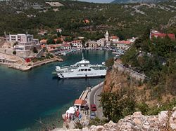 Port of Jablanac | |
 Jablanac | |
| Coordinates: 44°42′24″N14°53′44″E / 44.7067°N 14.8956°E | |
| Country | |
| County | Lika-Senj |
| City | Senj |
| Area | |
• Total | 54.0 km2 (20.8 sq mi) |
| Population (2021) [2] | |
• Total | 53 |
| • Density | 0.98/km2 (2.5/sq mi) |
| Time zone | UTC+1 (CET) |
| • Summer (DST) | UTC+2 (CEST) |
Jablanac is a village in Lika-Senj County, Croatia, located on the Adriatic Sea underneath the Velebit mountain, overlooking the island of Rab. The village used to have a ferry port that connected it to Rab, but that moved up the coast to Stinica in July 2012. The population of Jablanac is 83 (2011) [3] and it is located in the municipality of Senj (which lies to the north).
Contents
Local attractions include Zavratnica inlet where you can see a sunken military ferry wreck from WW2 and stunning scenery. Nearby is the Velebit mountain and the Northern Velebit National Park.