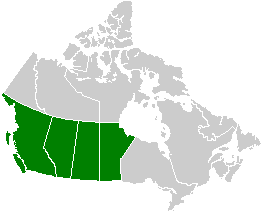
The Northern Cordilleran Volcanic Province (NCVP), formerly known as the Stikine Volcanic Belt, is a geologic province defined by the occurrence of Miocene to Holocene volcanoes in the Pacific Northwest of North America. This belt of volcanoes extends roughly north-northwest from northwestern British Columbia and the Alaska Panhandle through Yukon to the Southeast Fairbanks Census Area of far eastern Alaska, in a corridor hundreds of kilometres wide. It is the most recently defined volcanic province in the Western Cordillera. It has formed due to extensional cracking of the North American continent—similar to other on-land extensional volcanic zones, including the Basin and Range Province and the East African Rift. Although taking its name from the Western Cordillera, this term is a geologic grouping rather than a geographic one. The southmost part of the NCVP has more, and larger, volcanoes than does the rest of the NCVP; further north it is less clearly delineated, describing a large arch that sways westward through central Yukon.

A volcanic belt is a large volcanically active region. Other terms are used for smaller areas of activity, such as volcanic fields or volcanic systems. Volcanic belts are found above zones of unusually high temperature where magma is created by partial melting of solid material in the Earth's crust and upper mantle. These areas usually form along tectonic plate boundaries at depths of 10 to 50 kilometres. For example, volcanoes in Mexico and western North America are mostly in volcanic belts, such as the Trans-Mexican Volcanic Belt that extends 900 kilometres (560 mi) from west to east across central-southern Mexico and the Northern Cordilleran Volcanic Province in western Canada. In the case of Iceland, the geologist G.G. Bárdarson in 1929 identified clusters of volcanic belts while studying the Reykjanes Peninsula.

The Powder Mountain Icefield, also called the Powder Mountain Icecap and the Cayley Icefield, is a glacial field in the Pacific Ranges of southwestern British Columbia, Canada, about 20 kilometres (12 mi) west of Whistler and about 90 kilometres (56 mi) north of Vancouver. On the west side of the icefield is the valley of the Squamish River, while on its east is the Callaghan Valley, which is the setting for the Nordic facilities for the 2010 Winter Olympics.
Maitland Volcano is a heavily eroded shield volcano in the Northern Interior of British Columbia, Canada. It is 83 km (52 mi) southeast of the small community of Telegraph Creek in what is now the Klappan Range of the northern Skeena Mountains. This multi-vent volcano covered a remarkably large area and was topped by a younger volcanic edifice. Little remains of Maitland Volcano today, limited only to eroded lava flows and distinctive upstanding landforms created when magma hardened within the vents of the volcano.
Powder Mountain, 2,347 m (7,700 ft), is a volcanic summit in the Powder Mountain Icefield in the Pacific Ranges of the Coast Mountains in southwestern British Columbia, Canada.

Little Ring Mountain, also called Little Ring Peak, is a tuya in the Pacific Ranges of the Coast Mountains in southwestern British Columbia, Canada. It lies at the head of the Squamish and Soo Rivers. Part of the Mount Cayley volcanic field, its most recent eruption most likely occurred during the Fraser Glaciation.
Kana Cone is a red nested cinder cone in northern British Columbia, Canada, located northeast of Eve Cone in Mount Edziza Provincial Park. The name of the cone was adopted 2 January 1980 on National Topographic System map 104G/12 after being submitted to the BC Geographical Names office by the Geological Survey of Canada, although the cone was labelled as Ashwell Cone on a 1988 Geological Survey of Canada map by Canadian volcanologist Jack Souther.
Camp Hill is a cinder cone in northern British Columbia, Canada. It is thought to have last erupted in the Holocene period.
Dark Mountain, formerly also known as Black Mountain, is a mountain in the Tanzilla Plateau of the Northern Interior of British Columbia, Canada, located northeast of the settlement of Dease Lake, near Cry Lake.

Volcanism of Western Canada has produced lava flows, lava plateaus, lava domes, cinder cones, stratovolcanoes, shield volcanoes, greenstone belts, submarine volcanoes, calderas, diatremes and maars, along with examples of more less common volcanic forms such as tuyas and subglacial mounds.
Keda Cone, sometimes mistakenly called Kena Cone and sometimes referred to by the numeronym SLF-9, is a cinder cone in northwestern British Columbia, Canada. It is located in the Snowshoe Lava Field of Mount Edziza Provincial Park, having last erupted during the Holocene epoch.
Klastline Cone is a cinder cone in northwestern British Columbia, Canada, located near Mount Edziza in Mount Edziza Provincial Park. It last erupted during the Pleistocene epoch.
Pharaoh Dome is a lava dome in northwestern British Columbia, Canada, located near Mount Edziza in Mount Edziza Provincial Park. It last erupted during the Pleistocene epoch.
Nanook Dome is a lava dome in northwestern British Columbia, Canada, located just northeast of Mount Edziza in Mount Edziza Provincial Park. It last erupted during the Pleistocene epoch.
Sphinx Dome is a lava dome in northwestern British Columbia, Canada, located near Mount Edziza in Mount Edziza Provincial Park. It last erupted during the Pleistocene epoch.
Iskut Canyon Cone, also known as Iskut River Cone, is a cinder cone of the Iskut-Unuk River Cones group in northwestern British Columbia, Canada, located on the steep southern flank of the Iskut valley near its junction with Forrest Kerr Creek. It last erupted during the Holocene epoch.
Fort Selkirk Vent is a geological name for a cinder cone in central Yukon, Canada, located just east of Fort Selkirk along the Yukon River.
Mess Lake Cone is a cinder cone in northwestern British Columbia, Canada. It is polygenetic in nature, meaning it has had more than one period of eruptions throughout its history. Mess Lake Cone is one of the volcanoes that produced young basaltic lava flows in the central portion of the Mount Edziza volcanic complex in the past 10,000 years. These basaltic lava flows form a north–south trending volcanic field called the Mess Lake Lava Field.
Jack Gordon Souther was an American-born Canadian geologist, volcanologist, professor and engineer. He contributed significantly to the early understanding of recent volcanic activity in the Canadian Cordillera. Many of his publications continue to be regarded as classics in their field, even now several decades after they were written.


