Related Research Articles
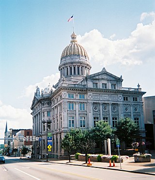
Westmoreland County is a county in the Commonwealth of Pennsylvania, United States. As of the 2020 census, the population was 364,663. The county seat is Greensburg. Formed from, successively, Lancaster, Northumberland, and later Bedford counties, Westmoreland County was founded on February 26, 1773, and was the first county in the colony of Pennsylvania whose entire territorial boundary was located west of the Allegheny Mountains. Westmoreland County originally included the present-day counties of Fayette, Washington, Greene, and parts of Beaver, Allegheny, Indiana, and Armstrong counties. It is named after Westmorland, a historic county of England.
East Deer Township is a township in Allegheny County, Pennsylvania, United States. The population was 1,500 at the 2010 census.

Forward Township is a township in Allegheny County, Pennsylvania, United States. The population was 3,068 at the 2020 census. The township is named after Walter Forward, U.S. Secretary of the Treasury from 1841 to 1843.

Monroeville is a home rule municipality in Allegheny County, Pennsylvania, United States. It is a suburb with mixed residential and commercial developments located about 10 miles east of Pittsburgh. As of the 2020 census, Monroeville was home to 28,640 people.

South Versailles Township is a township in Allegheny County, Pennsylvania, United States. The population was 351 at the 2010 census. It contains the village of Coulter, also called Coulterville or Coulters. The U.S. Post Office in the village is called Coulters.

Tarentum is a borough in Allegheny County in the U.S. state of Pennsylvania. It is 22 miles (35 km) northeast of Downtown Pittsburgh, along the Allegheny River. Tarentum was an industrial center where plate glass and bottles were manufactured; bricks, lumber, steel and iron novelties, steel billets and sheets, sack and wrapping paper were also produced.

West Deer Township is a township in Allegheny County, Pennsylvania, United States. The population was 11,771 at the 2010 census.

Plumcreek Township is a township in Armstrong County, Pennsylvania, United States. The population was 2,106 at the 2020 census, a decrease from the figure of 2,375 tabulated in 2010.

Buffalo Township is a township in Butler County, Pennsylvania, United States. The population was 7,307 at the 2010 census.

Derry Township is a township in Westmoreland County, Pennsylvania. It surrounds the Borough of Derry, which is a separate municipality. As of the 2020 census, the township population was 13,631.

Lower Burrell is a city in Westmoreland County in the U.S. state of Pennsylvania. Located approximately 18 miles northeast of downtown Pittsburgh, it is part of the Pittsburgh metropolitan area. The population was 11,761 at the 2010 census. The population of Lower Burrell was 11,078 in 2019.
Penn Township is a township in Westmoreland County, Pennsylvania, United States.

Rostraver Township is a township in Westmoreland County, Pennsylvania, United States. The population was 11,374 at the 2020 census.

Smithton is a borough in Westmoreland County, Pennsylvania, United States. The population was 399 at the 2010 census. As of 2018, the population was listed at 378. Smithton has its own post office, with zip code 15479, and is serviced by Yough School District.

Upper Burrell Township is a township in Westmoreland County, Pennsylvania, United States, within the Pittsburgh metropolitan area. The population was 2,159 at the 2020 census.

Trafford is a borough in Allegheny and Westmoreland counties in the U.S. state of Pennsylvania. Located near Pittsburgh in western Pennsylvania, the borough lies primarily in Westmoreland County; only a small portion extends into Allegheny County. It was incorporated in 1904 from the northernmost corner of North Huntingdon Township, and was named by George Westinghouse for Trafford near Manchester, England. Westinghouse purchased the land in 1902, and the Trafford Foundry began operations on October 3, 1903. The population was 3,174 at the 2010 census. Of this, 3,113 were in Westmoreland County, and only 61 were in Allegheny County.

Harrison Township is a township in Allegheny County in the U.S. state of Pennsylvania. The population was 10,169 at the 2020 census. Pennsylvania Route 28 passes through Harrison Township, connecting Kittanning to the northeast and Pittsburgh to the southwest. Allegheny Technologies has extensive steel mill facilities in Harrison Township, including its Allegheny Ludlum Brackenridge Works. Harrison Township is located at the far northeast corner of Allegheny County. Its northern border is the Butler County line and the Allegheny River forms the township's eastern boundary with Westmoreland County. Its northeast corner also touches Armstrong County.
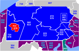
Area code 412 is a telephone area code in the North American Numbering Plan (NANP) for the Commonwealth of Pennsylvania. The numbering plan area (NPA) comprises the city of Pittsburgh, most of surrounding Allegheny County, and small portions of Washington and Westmoreland counties. The area code was one of the original North American area codes created in 1947, when it was assigned to the entire southwestern corner of the state.
Ruffs Dale, Pennsylvania, also spelled Ruffsdale, is an unincorporated community in East Huntingdon Township, Westmoreland County, Pennsylvania. It is located about forty miles from Pittsburgh. Ruffs Dale has its own post office, with zip code 15679, located at 875 State Route 31.
Karns is an unincorporated community in Harrison Township, Allegheny County, Pennsylvania, United States; it is located in Western Pennsylvania within the Pittsburgh Metropolitan Statistical Area, approximately 24 miles (39 km) northeast of Pittsburgh. Karns is situated along the Allegheny River at Pool 4 across from Jacks Island just above Lock and Dam 4 between Natrona, Natrona Heights, and Sligo. The elevation of Karns is 817 feet above sea level.
References
- 1 2 "Jacks Island". Geographic Names Information System . United States Geological Survey, United States Department of the Interior . Retrieved 2009-11-25.