
Absaroka–Beartooth Wilderness was created from existing National Forest lands in 1978 and is located in Montana and Wyoming, United States. The wilderness is partly in Gallatin, Custer and Shoshone National Forests and is composed of 944,000 acres (3,820 km2). The wilderness encompasses two distinct mountain ranges, namely the Beartooth and Absaroka ranges. These ranges are completely distinct geologically speaking with the Absarokas composed primarily of volcanic and metamorphic rock, while the Beartooths are made up almost entirely of granitic rocks. The Absarokas are noted for their dark and craggy appearance, lush and heavily forested valleys and abundant wildlife. The highest peak in the range, located in Wyoming, is Francs Peak at 13,153 feet (4,009 m). The Beartooths are more alpine with huge treeless plateaus and the highest peak in the state of Montana. The wilderness contains 30 peaks over 12,000 feet (3,700 m). The wilderness is an integral part of the 20-million-acre (81,000 km2) Greater Yellowstone Ecosystem and borders Yellowstone National Park.

Glacier Peak Wilderness is a 566,057-acre (229,075 ha), 35-mile-long (56 km), 20-mile-wide (32 km) wilderness area located within portions of Chelan, Snohomish, and Skagit counties in the North Cascades of Washington. The area lies within parts of Wenatchee National Forest and Mount Baker National Forest and is characterized by heavily forested stream courses, steep-sided valleys, and dramatic glacier-crowned peaks. The dominant geologic feature of the area is 10,541-foot (3,213 m) Glacier Peak. It is the most remote major volcanic peak in the Cascade Range and has more active glaciers than any other place in the lower forty-eight states. Glacier Peak is a volcanic cone of basalt, pumice, and ash which erupted during periods of heavy glaciation.

The Mission Mountains or Mission Range are a range of the Rocky Mountains located in northwestern Montana in the United States. They lie chiefly in Lake County and Missoula County and are south and east of Flathead Lake and west of the Swan Range. On the east side of the range is the Swan River Valley and on the west side the Mission Valley.

The Purcell Wilderness Conservancy is a provincial park in British Columbia, Canada. It was established in 1974, and encompasses six large drainages in the Purcell Mountains in the southeast of the province. It contains high peaks, alpine meadows and ridges, deep creek and river valleys, and hot springs at Dewar Creek.
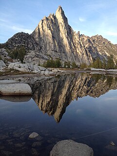
The Enchantments is a region within the Alpine Lakes Wilderness area of Washington state’s Cascade Mountain Range. At an elevation of 4,500 feet, it is home to over 700 alpine lakes and ponds surrounded by the vast peaks of Cashmere Crags, which rate among the best rock-climbing sites in the western United States. The highest peak, Dragontail Peak, stretches 8,840 feet high. The Enchantments is located 15 miles southwest of the popular Bavarian-themed town Leavenworth, Washington in the United States and is regarded as one of the most spectacular regions in the Cascade Range.

The Sawtooth Range is a mountain range of the Rocky Mountains in central Idaho, United States, reaching a maximum elevation of 10,751 feet (3,277 m) at the summit of Thompson Peak. It encompasses an area of 678 square miles (1,756 km2) spanning parts of Custer, Boise, Blaine, and Elmore counties, and is bordered to the east by the Sawtooth Valley. Much of the mountain range is within the Sawtooth Wilderness, part of the Sawtooth National Recreation Area and Sawtooth National Forest.

The Foss River is a stream in the U.S. state of Washington. It has two main forks, the East Fork Foss River and the West Fork Foss River. The main stem is formed by the confluence of the two forks. The river and its forks rise near in the Alpine Lakes Wilderness area of Mount Baker-Snoqualmie National Forest in the Cascade Mountains and flows generally north, joining the Tye River to form the South Fork Skykomish River. The Foss River's waters eventually empty into Puget Sound near Everett via the Skykomish River and Snohomish River.

The Flat Tops is a mountain range located in Colorado within the Routt and White River National Forests. Much of the range is within the boundary of the Flat Tops Wilderness Area. While there are notable peaks in the Flat Tops, the dominant feature of the range is the high plateau from which the peaks arise. The plateau forms the northeastern portion of the White River Uplift capped by horizontal basalt flows from tertiary volcanic activity and is bounded by steep drops to valleys carved out by subsequent glaciation. The resulting mix of areas of treeless plateau at an elevation of 11,000 to 12,000 feet interspersed with verdant valleys is unique among Colorado mountain ranges. The area contains approximately one hundred and ten ponds and lakes and is home to a wide variety of plants and animals, including many large mammals such as moose, elk, mule deer, black bear, and cougars. This area has been affected by the non-native plant species, yellow toadflax. The most common trees are Engelmann spruce, subalpine fir and lodgepole pine, with aspen groves at lower elevations. The top of the plateau is alpine tundra.
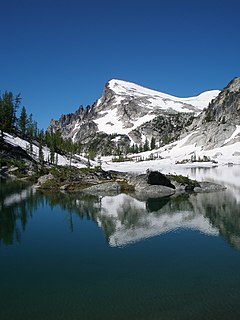
Little Annapurna is an 8,440+ ft granite summit located in Chelan County of Washington state. The origin of the name came from the Sherpa Climbing Club of Ellensburg, and is inspired by the obvious resemblance to its Himalayan namesake when comparing the south faces of both. Little Annapurna is part of The Enchantments within the Alpine Lakes Wilderness, and is set on land managed by Okanogan-Wenatchee National Forest. It belongs to the Stuart Range which is subset of the Cascade Range. Little Annapurna is situated southeast of Dragontail Peak, which is its nearest higher neighbor. Remnants of the receding Snow Creek Glacier can be found on its gentle north slope. Precipitation runoff drains into tributaries of the Wenatchee River.
Ingalls Peak is a 7,662-foot (2,335-metre) triple-summit mountain located in the Alpine Lakes Wilderness, along the common border of Kittitas County and Chelan County, in Washington state. Ingalls Peak is the highest point in the Teanaway area of the Wenatchee Mountains. It is situated 2 mi (3.2 km) west of Mount Stuart, and immediately west of Lake Ingalls, on land managed by Wenatchee National Forest. Its subpeaks are the South Peak and the East Peak. Precipitation runoff from the peak drains north into Jack Creek, a tributary of Icicle Creek; west into Fortune Creek; or east into Ingalls Creek, a tributary of the Wenatchee River. This peak, the lake, creek, and pass are named for Captain Benjamin Ingalls of the United States Cavalry who led an 1855 survey of this area and is credited with discovering gold in the region.
Bulls Tooth is a 6,840+ ft multi-peak mountain located in Chelan County of Washington state. Bulls Tooth is situated 5.5 mi (8.9 km) southeast of Stevens Pass, and within the Alpine Lakes Wilderness, on land managed by Okanogan-Wenatchee National Forest. Bulls Tooth is part of the Chiwaukum Mountains, which are a subset of the Cascade Range. Its nearest higher neighbor is Snowgrass Mountain, 3.3 mi (5.3 km) to the east. Precipitation runoff from the peak drains into tributaries of Icicle Creek, which in turn is a tributary of the Wenatchee River. This mountain was named by Albert Hale Sylvester for its resemblance to a tooth.

Jim Hill Mountain is a prominent 6,765 ft (2,060 m) mountain summit located in Chelan County of Washington state. Jim Hill Mountain is situated 3.5 mi (5.6 km) east of Stevens Pass, on the boundary of Alpine Lakes Wilderness, on land managed by Okanogan-Wenatchee National Forest. Jim Hill Mountain is part of the Chiwaukum Mountains, which are a subset of the Cascade Range. Its nearest higher neighbor is Bulls Tooth, 3.8 mi (6.1 km) to the south. Precipitation runoff from the peak drains into tributaries of Nason Creek, which in turn is a tributary of the Wenatchee River. Jim Hill Mountain is set immediately south of the east portal of the Cascade Tunnel, which was built by the Great Northern Railway. This mountain was named by Albert Hale Sylvester to honor James J. Hill (1838–1916), the chief executive officer of the Great Northern Railway.Hill became known during his lifetime as "The Empire Builder", a name bestowed to the Empire Builder passenger train that runs from Seattle to Chicago, and traverses below this mountain.

Cape Horn is a 7,316-foot (2,230-metre) mountain summit located in Chelan County of Washington state. Cape Horn is situated 12 mi (19 km) west-northwest of Leavenworth, within the Alpine Lakes Wilderness, on land managed by Okanogan-Wenatchee National Forest. Cape Horn is part of the Chiwaukum Mountains, a subset of the Cascade Range. Its nearest higher neighbor is Ladies Peak, 0.9 mi (1.4 km) to the northwest, and Grindstone Mountain is set 1.4 mi (2.3 km) to the south. Precipitation runoff from Cape Horn drains west to Icicle Creek, whereas the east slopes drain into Chiwaukum Creek, and both are tributaries of the Wenatchee River. Although modest in elevation, relief is significant since this peak rises over 4,300 feet above Icicle Creek Valley in approximately two miles. This mountain was named by Albert Hale Sylvester in 1909 for its sharp profile.
Alturas Lake is a freshwater lake located on the northern slope of Bald Eagle Peak, in King County, Washington. Access to Alturas Lake is through Necklace Valley Trail #1062 off Foss River Road, which exits US Highway 2 approximately at mile marker 50.5, just east of the Skykomish Ranger Station. The trail ends in Jade Lake further East from Alturas Lake. Self-issued Alpine Lake Wilderness permit required for transit within the Necklace Valley area.
Angeline Lake is a freshwater lake located on the northern slope of Iron Cap Mountain between Otter Lake, Azure Lake and Big Heart Lake, in King County, Washington. Self-issued Alpine Lake Wilderness permit required for transit within the Big Snow Mountain area. West Fork Foss River exits Angeline Lake into a canyon that produces Angeline Falls downstream from Chetwoot Lake to Delta Lake. Because Angeline Lake is at the heart of the Alpine Lakes Wilderness, the lake is a popular area for hiking, swimming, and fishing golden trout, rainbow trout, and cutthroat trout.
Chetwoot Lake is a freshwater lake located on the western slope of Iron Cap Mountain next to Crawford Lake, in King County, Washington. West Fork Foss River exits Chetwoot Lake towards Angeline Lake and then to a canyon that produces Angeline Falls downstream towards Delta Lake. Because Angeline Lake is at the heart of the Alpine Lakes Wilderness, the lake is a popular area for hiking, swimming, and fishing.
Opal Lake, also known as Necklace Valley Lake 3, is a freshwater lake located on the western region of the Alpine Lakes Wilderness, in King County, Washington. The lake is connected by stream to Emerald Lake and Jade Lake, which form together the Neckelace Valley Lakes. Opal Lake and its surrounding lakes and peaks are a popular area for hiking, swimming, and fishing Rainbow trout. Self-issued Alpine Lake Wilderness permit required for transit within the Necklace Valley area.
Emerald Lake is a freshwater lake located on the western region of the Alpine Lakes Wilderness, in King County, Washington. It is one of three lakes that are connected by stream which together form the Neckelace Valley Lakes. Emerald Lake and its surrounding lakes and peaks are a popular area for hiking, swimming, and fishing cutthroat trout and rainbow trout. Self-issued Alpine Lake Wilderness permit required for transit within the Necklace Valley area.
Lake Iiswoot is a freshwater lake located on the western region of the Alpine Lakes Wilderness, in King County, Washington. It is located on the eastern slope of Necklace Valley. Lake Iiswoot and its surrounding lakes and peaks is a popular area for hiking, swimming, and fishing. Self-issued Alpine Lake Wilderness permit required for transit within the Necklace Valley area.
Otter Lake is a freshwater lake located on the western slope of Otter Point northwest of Maple Valley in King County, Washington. Self-issued Alpine Lake Wilderness permit required for transit within the Big Snow Mountain area. Other prominent lakes are west of Otter Lake, including Angeline Lake, Azurite Lake and Big Heart Lake, while Opal Lake and other Necklace Valley lakes are on the eastern slope of Otter Point. Because Otter Lake is at the heart of the Alpine Lakes Wilderness, the lake is a popular area for hiking, swimming, and fishing.

