Baripada is a city and a municipality in Mayurbhanj district in the state of Odisha, India. Located along the east bank of the Budhabalanga river, Baripada is the cultural centre of north Odisha. In recent years, it has emerged as an educational hub with the opening of numerous professional colleges.
Malshiras is a town and the headquarters of Malshiras taluka in Solapur district of Maharashtra state in western India. Its governing body is promoted to Nagar Panchayat from a Gram Panchayat in 2017. There are many popular towns in Malshiras taluka such as Akluj, Natepute, Mahalung, Malinagar, Velapur and popular Villages like Goradwadi, Bhamburdi, Medad and Palasmandal.
Haldibari is a city and a municipality in the Mekhliganj subdivision of the Cooch Behar district in the Indian state of West Bengal.

Kadipur is a town, tehsil and a nagar panchayat in Sultanpur district in the Indian state of Uttar Pradesh. It is located a short distance from the bank of the Gomti River, at a crossroads between two roads heading from Sultanpur to Surapur and from Pratapgarh to Dostpur and then on to Akbarpur. On the north side of town is a stream with a steep ravine that drains the surrounding area. The road to Sultanpur crosses over this stream on a bridge. The lands surrounding Kadipur are average quality for agricultural purposes. As of 2011, Kadipur has a population of 8,010 people, in 1,216 households.
Karanjia is a town in the eastern Indian state of Odisha, about 221 kilometres (134 mi) north of the state capital Bhubaneswar. It is the sub-divisional headquarter of Panchpir sub-division and a Notified Area Council in Mayurbhanj district. It is bounded on its South-East by Deo river which forms the natural district border for Mayurbhanj.
Mansinghapur is a census town in Jagatballavpur CD Block of Howrah Sadar subdivision in Howrah district in the Indian state of West Bengal. It is close to Bargachia.
Purusottampur is a town and a Notified Area Council in Ganjam district in the Indian state of Odisha.
Fatehabad is a town in Agra district in the state of Uttar Pradesh, India. It is nearly 35 km south-east of Agra in the direction of Etawah. The historical name of the town is Samugarh.
Lingmoo is a village in South District of Sikkim, India. It is 50.4 km from Gangtok, capital of Sikkim. It falls under Ravangla sub-division. Lingmoo is divided into upper-Lingmo, Pepthang, Tokday, Kolthang, Mangzing and blocks. Tokday has 265 households with population of 1339, of which 680 are males and 659 are females as per Census 2011. Kolthang has 241 households with 1249 population, of which 634 are males and 615 are females as per 2011 Census. Mangzing has 216 homes with 1134 population, of which 599 are males and 535 are females as per Census 2011. A total of 59 families reside in Lingmo block as per Government of India 2011 Census. It has a Population of 297, of which 161 are males and 136 are females as per 2011 Census. Lingmo has a literacy rate of 75.30%. The village has of mixed population of Hindus, Buddhists and Christians. Male literacy stands at 80.43% and female literacy at 68.81%. The village is administered by Panchayat President. It lies within Yangang-Rangang constituency of Sikkim Legislative Assembly. Lingmo is divided into Mangzing, Kolthang and Tokdey blocks of the constituency.
Kandipedu is a village in Katpadi, at the northern part of Vellore city in the Indian state of Tamil Nadu. It sits on the Katpadi-Vallimalai railway line, near Thiruvalluvar University, one of India's premier educational institutions.
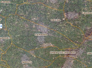
Zainabad is a village located in DAHINA Block of Rewari district in Haryana. Positioned in rural area of Rewari district of Haryana, it is one of the 39 villages of Dahina Block of Rewari district. As per the government records, the village code of Zainabad is 62460. The village has 1072 families.
Babariya is a village / panchayat located in the Gir Gadhada Taluka of Gir Somnath district in Gujarat State, India. Earlier, until August 2013, Babariya was part of Una Taluka and Junagadh district. The latitude 20.97097 and longitude 70.867234 are the geo-coordinate of the Village Babariya. Gandhinagar is the state capital of Babariya village which is located around 375 kilometres away from Babariya.
Juna Ugla is a village / panchayat located in the Gir Gadhada Taluka of Gir Somnath district in Gujarat State, India. Earlier, until August 2013, Juna Ugla was part of Una Taluka and Junagadh district. The latitude 20.914066 and longitude 71.032297 are the geo-coordinate of the Village Juna Ugla. Gandhinagar is the state capital of Juna Ugla village which is located around 375 kilometres away from Juna Ugla.
Shamshernagar is a large village in the Daudnagar subdivision and block in Aurangabad district, located in Bihar, India. The town falls under the jurisdiction of the Magadh division. Situated on the bank of the Sone River, the National Highway 139 passes through the village. The Indrapuri Barrage canal is a local waterway. Shamshernagar is densely populated. It has adequate infrastructure, including a middle school, an intermediate high school, an additional Primary Health Centre, and a Regional Rural Bank (MBGB). Shamshernagar is an electrified village. and possesses a water tank for its water supply. It shares a border between Aurangabad and Arwal districts. Buses, auto-rickshaws and e-rickshaws provide regional transportation.
Kharsawan block is a CD block that forms an administrative division in the Seraikela Sadar subdivision of Seraikela Kharsawan district, in the Indian state of Jharkhand.

Gobindpur block is a CD block that forms an administrative division in the Seraikela Sadar subdivision of Seraikela Kharsawan district, in the Indian state of Jharkhand.
Potka block is a CD block that forms an administrative division in the Dhalbhum subdivision of East Singhbhum district, in the Indian state of Jharkhand.
Dumaria block is a CD block that forms an administrative division in the Ghatshila subdivision of East Singhbhum district, in the Indian state of Jharkhand.
Gurbandha block is a CD block that forms an administrative division in the Ghatshila subdivision of East Singhbhum district, in the Indian state of Jharkhand.
Baharagora block is a CD block that forms an administrative division in the Ghatshila subdivision of East Singhbhum district, in the Indian state of Jharkhand.


