
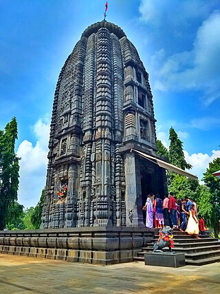
Baripada is a city and a municipality in Mayurbhanj district in the state of Odisha, India. Located along the east bank of the Budhabalanga river, Baripada is the cultural centre of north Odisha. In recent years, it has emerged as an educational hub with the opening of numerous professional colleges.
Mayurbhanj district is one of the 30 districts in the Odisha state of eastern India. It holds the distinction of being the largest district in Odisha by area. The district's headquarters is located in Baripada, with other major towns including Rairangpur, Karanjia, and Bahalda. As of 2011, Mayurbhanj ranks as the third-most populous district in Odisha, following Ganjam and Cuttack.
Garhwa is a City and a municipality in, and headquarters of, Garhwa district in the state of Jharkhand, India. Uttar Pradesh, Chhattisgarh and Bihar are nearby states. Garhwa Road (Rehla) is a major Railway Junction where thousands of passengers find this station most convenient to catch their train for Delhi and Kolkata. Bus services are available for Ranchi, Ambikapur, Gaya, etc.
Chandwa block is a community development block in Latehar district, in Indian state of Jharkhand. It is located around 75 km from Ranchi, the state capital. It is mineral rich like most of Jharkhand State. It lies at the junction for the NH39 and NH99 roads and is also an important railway junction.

Rairangpur is a city and a tehsil in the Mayurbhanj district of the state of Odisha, India. It is located 287 kilometres from the state capital Bhubaneswar, 82 kilometres from the district headquarters of Baripada, and about 73 kilometres from Jamshedpur. Rairangpur is the second largest city in the Mayurbhanj district, a notable mining area of Odisha, producing iron-ore from the Gorumahisani, Badampahar, and Suleipat mines.

Chakradharpur is a municipal town situated in the West Singhbhum district of Jharkhand, India, positioned strategically on the Chota Nagpur Plateau. Located 62 kilometers west of Jamshedpur, 115 kilometers south of Ranchi, and 101 kilometers east of Rourkela, it serves as a crucial hub for the mineral-rich regions of Jharkhand and Odisha, as well as for the cement, steel, and limestone industries in the vicinity. The town spans an urban area of 10 square kilometers and stands at an elevation of 227 meters. It shares its borders with Jamshedpur to the east, Rourkela to the west, Ranchi to the north, and Chaibasa to the south, which also serves as the district headquarters of West Singhbhum.
Baharagora is a town in the Baharagora CD block in the Ghatshila subdivision of the East Singhbhum district, in the Indian state of Jharkhand.
Jhumpura is a census town and a block in Kendujhar district in the Indian state of Odisha.
Karanjia is a town and a Municipality in the eastern Indian state of Odisha, about 221 kilometres (134 mi) north of the state capital Bhubaneswar. It is the sub-divisional headquarter of Panchpir sub-division and a NCA in Mayurbhanj district. It is bounded on its South-East by Deo river which forms the natural district border for Mayurbhanj.
Remuna is a town and a notified area committee in Baleswar district in the Indian state of Odisha. It is famous for the Khirachora Gopinatha Temple.
Bahalda is a small town in the Mayurbhanj district of northern Odisha, India. Bahalda is the second largest town in the Bamanghaty subdivision, and was the capital of Mayurbhanj in the 14th century. Maa Kichakeswari Temple, one of the most famous in northern Odisha, sits in the town.
National Highway 6 & Economic Corridor 1 (EC1), was a National Highway in India that has been separately designated under the new national highway numbering system. It was officially listed as running over 1,949 km (1,211 mi) from Surat to Kolkata. The route was also known as Asian Highway 46 (AH46) & Mumbai - Kolkata Highway and Great Eastern Highway.
Kudra, formerly known as Jahanabad, is a town and corresponding community development block in Kaimur district in the state of Bihar, India. It is the third largest town in Kaimur district. It is situated about 18 km from District Headquarter Bhabua. As of 2011, the population of Kudra was 30986. The railway station in Kudra is connected to all major railway routes.

Bangriposi also known as Bangiriposi, Bangriposhi is a town in Mayurbhanj district, Odisha, India.

Barehipani Falls is a two-tiered waterfall located in Simlipal National Park in Mayurbhanj district in the Indian state of Odisha. It is one of the highest waterfalls in India.
Betnoti is a small town in the Mayurbhanj district in the state of Odisha, India. It is the block headquarter of the Betnoti block. It is 26 kilometres (16 mi) from Baripada, the district headquarters of Mayurbhanj, and 194 kilometres (121 mi) from Bhubaneswar, the capital of Odisha.
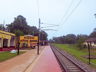
The Baripada Railway Station serves Baripada, the headquarters of Mayurbhanj district in the Indian state of Odisha.
Badagam is a small village in the Rayagada Block and Parlakhemundi municipality in Gajapati district in the Indian state of Odisha. The major languages spoken in this place are Kui and Oriya.
Rupsa is a town of Balasore district in Odisha.
Chadhaibhol is a village in the Mayurbhanj district of Odisha, India. It is the nearest village to Karanjia and Turumunga. It is located on NH 49 between Jashipur and Keonjhar. It is located 130 km west of district headquarters, Baripada, and 229 km from the state capital, Bhubaneswar.
