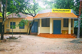
Gram Panchayat is a basic governing institution in Indian villages. It is a political institution, acting as the cabinet of a village or group of villages. The Gram Sabha works as the general body of the Gram Panchayat. The members of the gram panchayat are elected directly by the people. The gram panchayat is headed by an elected President and Vice President, assisted by a Secretary who serves as the administrative head of the panchayat. The president of a gram panchayat is known as a "Pradhan" or "Sarpanch" in Northern India. There are about 250,000 gram panchayats present in India.

Bijapur district, officially known as Vijayapura district, is a district in the state of Karnataka in India. The city of Bijapur is the headquarters of the district, and is located 530 km northwest of Bangalore. Bijapur is well known for the great monuments of historical importance built during the Adil Shahi dynasty.

Medak district is located in the western region of the Indian state of Telangana. Medak is the district headquarters. The district shares boundaries with Sangareddy, Kamareddy, Siddipet and Medchal-Malkajgiri districts.
A sarpanch, gram pradhan, mukhiya, or president is a decision-maker, elected by the village-level constitutional body of local self-government called the gram sabha in India. The sarpanch, together with other elected panchayat members, constitute gram panchayats and zilla panchayats. The sarpanch is the focal point of contact between government officers and the village community and retains power for five years. The term used to refer to the sarpanch can vary across different states of India. There are many commonly used terms for sarpanch in various states: panchayat president, gram pramukh, gram pradhan, gram adhyaksha, gaon panchayat president, gram panchayat president, etc.
Panchayat samiti or block panchayat is a rural local government (panchayat) body at the intermediate tehsil (taluka/mandal) or block level in India. It works for the villages of the tehsil that together are called a development block. It has been said to be the "panchayat of panchayats".

Panchayati raj is the system of local self-government of villages in rural India as opposed to urban and suburban municipalities.

Meerpet–Jillelguda is a satellite city of Hyderabad and a municipal corporation in Rangareddy district of the Indian state of Telangana. The municipal corporation was formed after merging municipality of Meerpet and Jillelguda.

Kuttampuzha is a village and gram panchayat in Ernakulam district in the Indian state of Kerala. Situated 71 km east of Kochi, Kuttampuzha panchayat is home to the 17.7% of total area of the Ernakulam District.
A tehsil is a local unit of administrative division in India and Pakistan. It is a subdistrict of the area within a district including the designated populated place that serves as its administrative centre, with possible additional towns, and usually a number of villages. The terms in India have replaced earlier terms, such as pargana (pergunnah) and thana.
Local government in India is governmental jurisdiction below the level of the state. Local self-government means that residents in towns, villages and rural settlements are the people who elect local councils and their heads authorising them to solve the important issues. India is a federal republic with three spheres of government: union, state and local. The 73rd and 74th constitutional amendments give recognition and protection to local governments and in addition each state has its own local government legislation. Since 1992, local government in India takes place in two very distinct forms. Urban localities, covered in the 74th amendment to the Constitution, have Municipality but derive their powers from the individual state governments, while the powers of rural localities have been formalized under the panchayati raj system, under the 73rd amendment to the Constitution.
Agara is a panchayat village in the southern state of Karnataka, India. It is located in the Mulbagal Taluka of Kolar district in Karnataka. There is another village named "Agara" in the Tayalur gram panchayat of Mulbagal Taluka: Agara, Tayalur.
Aldhal is a village in Belgaum district in the southern state of Karnataka, India. Administratively, it is part of the Naganur K D gram panchayat in Hukeri Taluka.
Ingalagi is a panchayat village in Belgaum district in the southern state of Karnataka, India.
Naganur (K.D.) is a panchayat village in Belgaum district of Karnataka, India.

Chanchal II is a community development block that forms an administrative division in Chanchal subdivision of Malda district in the Indian state of West Bengal.
Sansad Adarsh Gram Yojana is a rural development programme broadly focusing upon the development in the villages which includes social development, cultural development and spread motivation among the people on social mobilization of the village community. The programme was launched by the Prime Minister of India, Narendra Modi on the birth anniversary of Jayaprakash Narayan, on 11 October 2014.
Vatadra (Vatadara) is one of the larger villages of Cambay county of Anand district in Gujarat state (India). It is a gram panchayat village. Because of its size, it is the only village in its gram panchayat. Prior to 1997, it was located in Kaira District.

The Panchayat raj is a political system originating from the Indian subcontinent, primarily found in India and neighboring countries Pakistan, Bangladesh, Sri Lanka, and Nepal. It is one of the oldest systems of local government in the Indian subcontinent, with historical mentions dating back to around 250 CE. The word 'raj' means 'rule,' and panchayat' means 'assembly' (ayat) of 'five' (panch). Traditionally, panchayats consisted of wise and respected elders chosen and accepted by the local community. These assemblies resolved disputes between individuals and villages. However, there were various forms of such assemblies.
Jamda or JAMDA may refer to:

The Kuttippuram Block Panchayat is the block-level administrative body that administers the region around Kuttippuram in Malappuram district, Kerala, India. It is also one of the 15 Block Panchayats established for the proper block-level administration of Gram panchayats in the district. Established in 1962, the block's current president is Vaseema Veleri since 2020. Kuttippuram Block Panchayat lies in two assembly constituencies – Kottakkal and Tirur – both of which are part of the Ponnani parliamentary constituency. The Block is headed by a President and council, and manages 155.83 km2 of Kuttippuram block, with a population of about 229,468 within that area.


