Jenna Marie Massoli, known professionally as Jenna Jameson, is an American businesswoman, writer, television personality, and former pornographic film actress. She has been named the world's most famous adult entertainment performer and "The Queen of Porn".
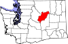
Withrow is an unincorporated community in Douglas County, Washington, United States.
The Hardscrabble Open, also known as the Hardscrabble Women's Invitation, was a golf tournament played at the Hardscrabble Golf Club in Fort Smith, Arkansas, from 1945 to 1953. It was an official LPGA Tour event from 1948 to 1950.
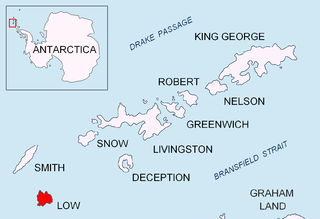
Jameson Point is a small headland on the north side of the entrance to Malina Cove, situated 6.3 km (3.9 mi) north of Cape Garry on the west side of Low Island, in the South Shetland Islands of Antarctica. It was roughly charted by the French Antarctic Expedition, 1908–10. The point was photographed from the air by the Falkland Islands and Dependencies Aerial Survey Expedition, 1955–57, and more accurately delineated from these photos by the Falkland Islands Dependencies Survey in 1959. The name "Jameson Island" was applied to Low Island by James Weddell in 1820–23, and Jameson Point has been approved for this point to preserve Weddell's name on Low Island.
Grandview is an unincorporated community in Washington County, in the U.S. state of Ohio.

Barneston is an extinct town in King County, in the U.S. state of Washington. The GNIS classifies it as a populated place.
Cromwell is an unincorporated community in Pierce County, in the U.S. state of Washington.
Edgewick is an unincorporated community in King County, in the U.S. state of Washington.
Glencove is an unincorporated community in Pierce County, in the U.S. state of Washington.
Hillhurst is an extinct town in Pierce County, in the U.S. state of Washington.
Kerriston is an extinct town in King County, in the U.S. state of Washington. The GNIS classifies it as a populated place.
Magnolia Beach is an unincorporated community in King County, in the U.S. state of Washington.
Raeco is an unincorporated community in King County, in the U.S. state of Washington.
Reiter is an unincorporated community in Snohomish County, in the U.S. state of Washington.
Robe is an unincorporated community in Snohomish County, in the U.S. state of Washington.
Rockdale is an extinct town in the northwest United States, in King County, Washington. The GNIS classifies it as a populated place.
Stillwater is an unincorporated community in King County, in the U.S. state of Washington.
Veazie is an unincorporated community in King County, in the U.S. state of Washington.
White is an unincorporated community in King County, in the U.S. state of Washington.
Whitney is an extinct town in Skagit County, in the U.S. state of Washington. The GNIS classifies it as a populated place.