
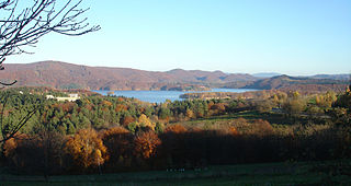
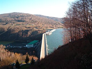
Lake Solina is an artificial lake in the Bieszczady Mountains region, more precisely in Lesko County of the Subcarpathian Voivodship of Poland. Its coordinates are 49°22′27″N22°27′8″E.
Polańczyk is a village in Lesko County, Subcarpathian Voivodeship, in south-eastern Poland. It lies in, and serves as the seat of, the administrative district of Gmina Solina. Polańczyk lies approximately 4 kilometres (2 mi) south-west of Solina, 14 km (9 mi) south-east of Lesko, and 80 km (50 mi) south of the regional capital Rzeszów. In 2002 the village had a population of 830.
Gmina Baligród is a rural gmina in Lesko County, Subcarpathian Voivodeship, in south-eastern Poland. Its seat is the village of Baligród, which lies approximately 15 kilometres (9 mi) south of Lesko and 79 km (49 mi) south of the regional capital Rzeszów.

Berezka is a village in the administrative district of Gmina Solina, within Lesko County, Subcarpathian Voivodeship, in south-eastern Poland. It lies approximately 23 kilometres (14 mi) north of Solina, 14 km (9 mi) north-east of Lesko, and 58 km (36 mi) south-east of the regional capital Rzeszów.
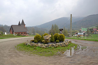
Solina is a village in Lesko County, Subcarpathian Voivodeship, in south-eastern Poland. It is the former seat of the gmina called Gmina Solina. It lies approximately 15 kilometres (9 mi) south-east of Lesko and 80 km (50 mi) south-east of the regional capital Rzeszów. In 2002 the village had a population of 190.
Cisna-Wetlina Landscape Park is a protected area in south-eastern Poland, established in 1992, covering an area of 510.14 square kilometres (196.97 sq mi).
San Valley Landscape Park is a protected area in south-eastern Poland, established in 1992, covering an area of 342.70 square kilometres (132.32 sq mi).

Bóbrka is a village in the administrative district of Gmina Solina, within Lesko County, Subcarpathian Voivodeship, in south-eastern Poland. It lies approximately 4 kilometres (2 mi) north of Solina, 11 km (7 mi) south-east of Lesko, and 76 km (47 mi) south-east of the regional capital Rzeszów.
Bukowiec is a village in the administrative district of Gmina Solina, within Lesko County, Subcarpathian Voivodeship, in south-eastern Poland. It lies approximately 10 kilometres (6 mi) south-west of Solina, 20 km (12 mi) south of Lesko, and 86 km (53 mi) south of the regional capital Rzeszów.
Górzanka is a village in the administrative district of Gmina Solina, within Lesko County, Subcarpathian Voivodeship, in south-eastern Poland. It lies approximately 9 kilometres (6 mi) south-west of Solina, 17 km (11 mi) south of Lesko, and 83 km (52 mi) south of the regional capital Rzeszów.
Myczków is a village in the administrative district of Gmina Solina, within Lesko County, Subcarpathian Voivodeship, in south-eastern Poland. It lies approximately 5 kilometres (3 mi) west of Solina, 13 km (8 mi) south-east of Lesko, and 79 km (49 mi) south of the regional capital Rzeszów.

Myczkowce is a village in the administrative district of Gmina Solina, within Lesko County, Subcarpathian Voivodeship, in south-eastern Poland. It lies approximately 8 kilometres (5 mi) north-west of Solina, 8 km (5 mi) south-east of Lesko, and 73 km (45 mi) south-east of the regional capital Rzeszów. In 1910-1914, new ukrainian church instead of a wooden one from 1815, was built. A monumental structure was designed as a synthesis of Ukrainian, Byzantine and Romanesque architectural traditions. Religious community was affiliated with and the Diocese of Peremyshl`. After the deportation of Ukrainians, was used for the storage, and since 1979 - as a church for Polish Roman Catholic community The village has a population of 510.
Rajskie is a village in the administrative district of Gmina Solina, within Lesko County, Subcarpathian Voivodeship, in south-eastern Poland. It lies approximately 8 kilometres (5 mi) south of Solina, 21 km (13 mi) south-east of Lesko, and 87 km (54 mi) south-east of the regional capital Rzeszów.
Rybne is a village in the administrative district of Gmina Solina, within Lesko County, Subcarpathian Voivodeship, in south-eastern Poland. It lies approximately 7 km southwest of Solina, 16 km (10 mi) south of Lesko, and 82 km (51 mi) south of the regional capital Rzeszów.
Terka is a village in the administrative district of Gmina Solina, within Lesko County, Subcarpathian Voivodeship, in south-eastern Poland. It lies approximately 10 kilometres (6 mi) south of Solina, 21 km (13 mi) south of Lesko, and 88 km (55 mi) south of the regional capital Rzeszów.
Werlas is a village in the administrative district of Gmina Solina, within Lesko County, Subcarpathian Voivodeship, in south-eastern Poland. It lies approximately 5 kilometres (3 mi) to the south of Solina, 18 km (11 mi) south-east of Lesko, and 84 km (52 mi) south-east of the regional capital Rzeszów.
Wola Matiaszowa is a village in the administrative district of Gmina Solina, within Lesko County, Subcarpathian Voivodeship, in south-eastern Poland. It lies approximately 7 kilometres (4 mi) west of Solina, 11 km (7 mi) south of Lesko, and 78 km (48 mi) south of the regional capital Rzeszów.

Wołkowyja is a village in the administrative district of Gmina Solina, within Lesko County, Subcarpathian Voivodeship, in south-eastern Poland. It lies approximately 7 kilometres (4 mi) south-west of Solina, 17 km (11 mi) south of Lesko, and 84 km (52 mi) south of the regional capital Rzeszów.
Zawóz is a village in the administrative district of Gmina Solina, within Lesko County, Subcarpathian Voivodeship, in south-eastern Poland. It lies approximately 4 kilometres (2 mi) south of Solina, 17 km (11 mi) south-east of Lesko, and 83 km (52 mi) south-east of the regional capital Rzeszów.


