Jawornik Ruski, also known as Yavirnyk Ruski is a village in the administrative district of Gmina Bircza, within Przemyśl County, Subcarpathian Voivodeship, in south-eastern Poland. It lies approximately 14 kilometres (9 mi) west of Bircza, 35 km (22 mi) west of Przemyśl, and 42 km (26 mi) south-east of the regional capital Rzeszów.

Widźgowo is a village in the administrative district of Gmina Brańsk, within Bielsk County, Podlaskie Voivodeship, in north-eastern Poland. It lies approximately 11 kilometres (7 mi) south of Brańsk, 25 km (16 mi) south-west of Bielsk Podlaski, and 54 km (34 mi) south of the regional capital Białystok.
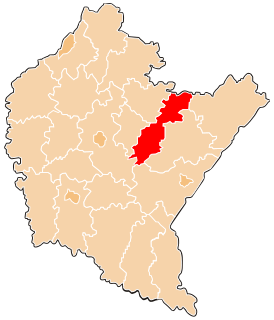
Kurzeszyn is a village in the administrative district of Gmina Rawa Mazowiecka, within Rawa County, Łódź Voivodeship, in central Poland. It lies approximately 8 kilometres (5 mi) north of Rawa Mazowiecka and 56 km (35 mi) east of the regional capital Łódź.
Jawornik is a village in the administrative district of Gmina Myślenice, within Myślenice County, Lesser Poland Voivodeship, in southern Poland. It lies approximately 5 kilometres (3 mi) north-west of Myślenice and 23 km (14 mi) south of the regional capital Kraków.
Hadle Kańczuckie is a village in the administrative district of Gmina Jawornik Polski, within Przeworsk County, Subcarpathian Voivodeship, in south-eastern Poland.
Hadle Szklarskie is a village in the administrative district of Gmina Jawornik Polski, within Przeworsk County, Subcarpathian Voivodeship, in south-eastern Poland. It lies approximately 22 kilometres (14 mi) south-west of Przeworsk and 25 km (16 mi) south-east of the regional capital Rzeszów.
Hucisko Jawornickie is a village in the administrative district of Gmina Jawornik Polski, within Przeworsk County, Subcarpathian Voivodeship, in south-eastern Poland. It lies approximately 22 kilometres (14 mi) south-west of Przeworsk and 29 km (18 mi) south-east of the regional capital Rzeszów.
Jawornik Polski is a village in Przeworsk County, Subcarpathian Voivodeship, in south-eastern Poland. It is the seat of the gmina called Gmina Jawornik Polski. It lies approximately 26 kilometres (16 mi) south-west of Przeworsk and 36 km (22 mi) south-east of the regional capital Rzeszów.
Manasterz is a village in the administrative district of Gmina Jawornik Polski, within Przeworsk County, Subcarpathian Voivodeship, in south-eastern Poland. It lies approximately 10 kilometres (6 mi) north-east of Jawornik Polski, 17 km (11 mi) south-west of Przeworsk, and 28 km (17 mi) east of the regional capital Rzeszów.
Widaczów is a village in the administrative district of Gmina Jawornik Polski, within Przeworsk County, Subcarpathian Voivodeship, in south-eastern Poland. It lies approximately 22 kilometres (14 mi) south-west of Przeworsk and 26 km (16 mi) south-east of the regional capital Rzeszów.
Zagórze is a village in the administrative district of Gmina Jawornik Polski, within Przeworsk County, Subcarpathian Voivodeship, in south-eastern Poland. It lies approximately 10 kilometres (6 mi) north-east of Jawornik Polski, 17 km (11 mi) south-west of Przeworsk, and 28 km (17 mi) east of the regional capital Rzeszów.
Jawornik is a village in the administrative district of Gmina Komańcza, within Sanok County, Subcarpathian Voivodeship, in south-eastern Poland, close to the border with Slovakia. It lies approximately 3 kilometres (2 mi) north-east of Komańcza, 23 km (14 mi) south of Sanok, and 76 km (47 mi) south of the regional capital Rzeszów.
Jawornik is a village in the administrative district of Gmina Niebylec, within Strzyżów County, Subcarpathian Voivodeship, in south-eastern Poland. It lies approximately 9 km (6 mi) south-east of Strzyżów and 23 km (14 mi) south of the regional capital Rzeszów.
Niebylec is a village in Strzyżów County, Subcarpathian Voivodeship, in south-eastern Poland. It is the seat of the gmina called Gmina Niebylec. Niebylec lies in eastern part of historic Lesser Poland, approximately 10 kilometres (6 mi) south-east of Strzyżów and 22 km (14 mi) south of the regional capital Rzeszów. The village has a population of 594, and is located along National Road Nr. 9, which also makes Polish part of the European route E371. Niebylec, even though a village now, used to be a town from 1509 until 1919.
Podkupientyn is a village in the administrative district of Gmina Sokołów Podlaski, within Sokołów County, Masovian Voivodeship, in east-central Poland. It lies approximately 3 kilometres (2 mi) north-east of Sokołów Podlaski and 90 km (56 mi) east of Warsaw.
Wyczechowo is a village in the administrative district of Gmina Somonino, within Kartuzy County, Pomeranian Voivodeship, in northern Poland. It lies approximately 4 kilometres (2 mi) east of Somonino, 7 km (4 mi) south-east of Kartuzy, and 28 km (17 mi) west of the regional capital Gdańsk.

Noor ud Din Mosque in Darmstadt, Germany is run by the Ahmadiyya Muslim Community. The foundation stone was laid in 2002 and was inaugurated in August 2003 by Mirza Masroor Ahmad, the 5th Caliph of the Ahmadiyya Muslim Community.

The Hefei railway station is a major railway station in Hefei, Anhui, China.

Baohua station is a Metro station of Shenzhen Metro Line 5. It opened on 22 June 2011. This station is an underground station.

Nógrádkövesd is a village in Nógrád County, Hungary with 683 inhabitants (2014).