Biography
Born at Saint-Michel de Villebernin, he grew up in the village in the small commune of Palluau-sur-Indre in central France. Having developed drawing and mapmaking skills, Franquelin migrated in 1671 from the Indre department to Nouvelle France (Quebec) to work as a trader.
New France Governor Louis de Buade de Frontenac soon recognized his talents and hired him to draw maps. Franquelin recorded the explorations of Louis Jolliet and René-Robert Cavelier de La Salle between 1674 and 1684. His 1684 map of Nouvelle France, including La Louisiane , became well known and served as the basis of maps by men from other countries.
In 1688 the King appointed Franquelin as royal hydrographer. He went to France in 1692 to complete a series of maps of the New England Atlantic coast, as the English and French were competing for control of territory in North America. He also continued to hold his appointment from New France from 1686 to 1697, and again from 1701 to 1703. But, from 1694 to 1707, he worked in France for Louis XIV's military engineer Vauban. Franquelin never returned to Canada. [2]
He had married and had 13 children with his wife. She and ten of their children drowned in a shipwreck in 1693, near Sept-Iles, Quebec. [2]

Biffeche or Bifeche is an area of Senegal centred on the town of Savoigne, around 30 kilometres north-east of the major coastal city of Saint-Louis.

Louis Jolliet was a French-Canadian explorer known for his discoveries in North America. In 1673, Jolliet and Jacques Marquette, a Jesuit Catholic priest and missionary, were the first non-Natives to explore and map the Upper Mississippi River.
Guillaume Delisle, also spelled Guillaume de l'Isle, or Guillelmo Delille was a French cartographer known for his popular and accurate maps of Europe and the newly explored Americas.

Jacques Nicolas Bellin was a French hydrographer, geographer, and member of the French intellectual group called the philosophes.

Joseph-Antoine le Fèbvre, sieur de La Barre was a French lawyer and administrator best known for his disastrous three years as governor of the colony of New France (Quebec).

The Big Bureau Creek is a 73-mile-long (117 km) tributary of the Illinois River in north central Illinois. It rises approximately 10 miles (16 km) north of Mendota and flows southwest into Bureau County, turning south at Princeton and then flowing east into the Illinois River floodplain. Among the creek's more notable features is the Red Covered Bridge, built in 1863, which passes over Big Bureau Creek and was once part of the Peoria Galena Trail. The bridge, located just north of Interstate 80, is listed on the National Register of Historic Places.

Claude-François Ménestrier was a French heraldist, writer, member of the Society of Jesus [Jesuit], and attendant of the royal court.

Charles Pierre Claret, comte de Fleurieu was a French Navy officer, explorer, hydrographer and politician. He served as Minister of the Navy under Louis XVI, and was a member of the Institut de France. His brother was botanist Marc Antoine Louis Claret de La Tourrette.

Franquelin is a municipality in Quebec, Canada, in the administrative region of Côte-Nord in RCM Manicouagan. Its population is 285 people over 430 square kilometres. Franquelin was founded at the foot of Massifs rocks of the Laurentians where impressive cliffs plunge to the Gulf of Saint Lawrence.
Jean-Baptiste is a male French name, originating with Saint John the Baptist, and sometimes shortened to Baptiste. The name may refer to any of the following:

Antoine Philippe de Marigny de Mandeville, Chevalier de St. Louis, was a French geographer and explorer. Born in Mobile in 1722, he was part of the Creole elite of French Louisiana.
François Berthelot, cartographer, hydrographer, and professor was one of a number of Marseille-based authors who extended man's knowledge of the Mediterranean Sea during the late 17th and early to mid 18th century. Other authors in this category include Henri Michelot, Laurens Bremond, Nicolas Therin, Joseph Roux and Jacques Ayrouard.
Between 1665 and 1670, seven Iroquois settlements on the north shore of Lake Ontario in present-day Ontario, collectively known as the "Iroquois du Nord" villages, were established by Senecas, Cayugas, and Oneidas. The villages consisted of Ganneious, Kente, Kentsio, Ganaraske, Ganatsekwyagon, Teiaiagon, and Quinaouatoua. The villages were all abandoned by 1701.
Jean-Baptiste de Bouge (1757–1833) was a Belgian cartographer whose career spanned decades of major political upheaval, his country in turn being the Austrian Netherlands, the United Belgian States, the French First Republic, the Napoleonic Empire, and the United Kingdom of the Netherlands, before becoming the Kingdom of Belgium. He often worked with the cartographic engraver Philippe Joseph Maillart.
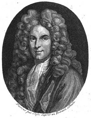
Nicolas de Blégny was a French essayist, historian and barber surgeon. He was appointed surgeon of Queen Maria Theresa of Spain in 1678, then physician of King Louis XIV in 1682.
Events from the year 1657 in France

The Saint-Augustin River is a salmon river in the Côte-Nord region of Quebec, Canada. It empties into the Gulf of Saint Lawrence.
Lake Franquelin is a freshwater body of the watershed of Franquelin River, in the unorganized territory of Rivière-aux-Outardes, in the Manicouagan, in the administrative region of Côte-Nord, in the province of Quebec, in Canada.
The rivière Franquelin is located in the unorganized territory of Rivière-aux-Outardes and the municipality of Franquelin, in the Manicouagan Regional County Municipality, in the administrative region of Côte-Nord, in the province of Quebec, in Canada.
