Abydos is one of the oldest cities of ancient Egypt, and also of the eighth nome in Upper Egypt. It is located about 11 kilometres west of the Nile at latitude 26° 10' N, near the modern Egyptian towns of El Araba El Madfuna and El Balyana. In the ancient Egyptian language, the city was called Abdju. The English name Abydos comes from the Greek Ἄβυδος, a name borrowed by Greek geographers from the unrelated city of Abydos on the Hellespont.

Thutmose I was the third pharaoh of the 18th Dynasty of Egypt. He received the throne after the death of the previous king, Amenhotep I. During his reign, he campaigned deep into the Levant and Nubia, pushing the borders of Egypt farther than ever before in each region. He also built many temples in Egypt, and a tomb for himself in the Valley of the Kings; he is the first king confirmed to have done this.

The New Kingdom, also referred to as the Egyptian Empire, is the period in ancient Egyptian history between the sixteenth century BC and the eleventh century BC, covering the Eighteenth, Nineteenth, and Twentieth dynasties of Egypt. Radiocarbon dating places the exact beginning of the New Kingdom between 1570 BC and 1544 BC. The New Kingdom followed the Second Intermediate Period and was succeeded by the Third Intermediate Period. It was Egypt's most prosperous time and marked the peak of its power.

Jebel Barkal or Gebel Barkal is a mesa or large rock outcrop located 400 km north of Khartoum, next to Karima in Northern State in Sudan, on the Nile River, in the region that is sometimes called Nubia. The mesa is 104 m tall, has a flat top, and came to have religious significance for both ancient Kush and ancient Egyptian occupiers. In 2003, the mountain, together with the extensive archaeological site at its base, were named as the center of a World Heritage Site by UNESCO. The Jebel Barkal area houses the Jebel Barkal Museum.

Senusret I also anglicized as Sesostris I and Senwosret I, was the second pharaoh of the Twelfth Dynasty of Egypt. He ruled from 1971 BC to 1926 BC, and was one of the most powerful kings of this Dynasty. He was the son of Amenemhat I. Senusret I was known by his prenomen, Kheperkare, which means "the Ka of Re is created." He expanded Egypt that allowed him to rule over an age of prosperity.
Qift is a small town in the Qena Governorate of Egypt about 43 km (27 mi) north of Luxor, situated under 26° north lat., on the east bank of the Nile. In ancient times its proximity to the Red Sea made it an important trading emporium between India, Punt, Felix Arabia and the North. It was important for nearby gold and quartzite mines in the Eastern Desert, and as a starting point for expeditions to Punt.
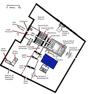
The Precinct of Amun-Re, located near Luxor, Egypt, is one of the four main temple enclosures that make up the immense Karnak Temple Complex. The precinct is by far the largest of these and the only one that is open to the general public. The temple complex is dedicated to the principal god of the Theban Triad, Amun, in the form of Amun-Re.
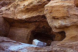
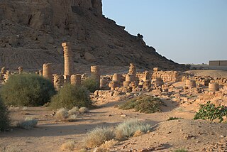
The Speos Artemidos is an archaeological site in Egypt. It is located about 2 km south of the Middle Kingdom tombs at Beni Hasan, and about 28 km south of Al Minya. Today, the site is a small village known as Istabl Antar.

Gebel el-Silsila or Gebel Silsileh is 65 km (40 mi) north of Aswan in Upper Egypt, where the cliffs on both sides close to the narrowest point along the length of the entire Nile. The location is between Edfu in the north towards Lower Egypt and Kom Ombo in the south towards Upper Egypt. The name Kheny means "The Place of Rowing". It was used as a major quarry site on both sides of the Nile from at least the 18th Dynasty to Greco-Roman times. Silsila is famous for its New Kingdom stelai and cenotaphs.

The Red Chapel of Hatshepsut or the Chapelle rouge was a religious shrine in Ancient Egypt.

The history of the Karnak Temple complex is largely the history of Thebes. The city does not appear to have been of any significance before the Eleventh Dynasty, and any temple building here would have been relatively small and unimportant, with any shrines being dedicated to the early god of Thebes, Montu. The earliest artifact found in the area of the temple is a small, eight-sided column from the Eleventh Dynasty, which mentions Amun-Re. The tomb of Intef II mentions a 'house of Amun', which implies some structure, whether a shrine or a small temple is unknown. The ancient name for Karnak, Ipet-Isut only really refers to the central core structures of the Precinct of Amun-Re, and was in use as early as the 11th Dynasty, again implying the presence of some form of temple before the Middle Kingdom expansion.

Ad-Dakka was a place in Lower Nubia. It is the site of the Greco-Roman Temple of Dakka, dedicated to Thoth, the god of wisdom in the ancient Egyptian pantheon. The temple was initially a small one-room shrine or chapel, first begun in the 3rd century BC by a Meroitic king named Arqamani in collaboration with Ptolemy IV who added an antechamber and a gate structure. Ptolemy IX "subsequently enlarged the temple by adding a pronaos with two rows of probably three columns." During the Roman period, the Emperors Augustus and Tiberius further enlarged the structure with "the addition, at the rear, of a second sanctuary as well as inner and outer enclosure walls with a large pylon. The sanctuary contained a granite naos." The Temple of Dakka was transformed into a temple fortress by the Romans and surrounded by a stone wall, 270 by 444 metres long, with an entrance along the Nile.

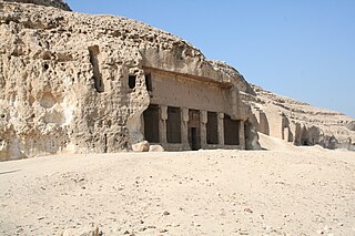
The Temple of Amada, the oldest Egyptian temple in Nubia, was first constructed by Pharaoh Thutmose III of the 18th dynasty and dedicated to Amun and Re-Horakhty. His son and successor, Amenhotep II continued the decoration program for this structure. Amenhotep II's successor, Thutmose IV decided to place a roof over its forecourt and transform it into a pillared or hypostyle hall. During the Amarna period, Akhenaten had the name Amun destroyed throughout the temple but this was later restored by Seti I of Egypt's 19th Dynasty. Various 19th Dynasty kings especially Seti I and Ramesses II also "carried out minor restorations and added to the temple's decoration." The stelas of the Viceroys of Kush Setau, Heqanakht and Messuy and that of Chancellor Bay describe their building activities under Ramesses II, Merneptah and Siptah respectively. In the medieval period the temple was converted into a church.
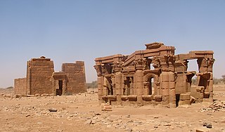
Naqa or Naga'a is a ruined ancient city of the Kushitic Kingdom of Meroë in modern-day Sudan. The ancient city lies about 170 km (110 mi) north-east of Khartoum, and about 50 km (31 mi) east of the Nile River located at approximately MGRS 36QWC290629877. Here smaller wadis meet the Wadi Awateib coming from the center of the Butana plateau region, and further north at Wad ban Naqa from where it joins the Nile. Naqa was only a camel or donkey's journey from the Nile, and could serve as a trading station on the way to the east; thus it had strategic importance.

Amenemopet served as Viceroy of Kush during the reign of Seti I.
This page list topics related to ancient Egypt.
The Temple of Amun is an archaeological site at Jebel Barkal in Northern State, Sudan. It is situated about 400 kilometres (250 mi) north of Khartoum near Karima. The temple stands near a large bend of the Nile River, in the region that was called Nubia in ancient times. The Temple of Amun, one of the largest temples at Jebel Barkal, is considered sacred to the local population. Not only was the Amun temple a main centre of what at one time was considered to be an almost universal religion, but, along with the other archaeological sites at Jebel Barkal, it was representative of the revival of Egyptian religious values. Up to the middle of the 19th century, the temple was subjected to vandalism, destruction, and indiscriminate plundering, before it came under state protection.

Korosko was a settlement on the Nile River in Egyptian Nubia. It was located 118 miles (190 km) south of Aswan and served as the point of departure for caravans avoiding the Dongola bend in the river by striking out directly across the desert to Abu Hamad and thereby bypassing the second, third and fourth cataracts of the Nile. The "Korosko route" or "Korosoko road" was in use during the period of the New Kingdom, when Pharaohs Thutmose I and Thutmose III marked it with boundary stelae. During the Meroitic period it was the main connection between the Kingdom of Kush and the Mediterranean world.
The Temple of Satet or Satis was an ancient Egyptian temple dedicated to the goddess Satet, a personification of the Nile inundation. The temple was located on the Nile Valley island of Elephantine, Egypt. Founded during the late Predynastic Period around 3200 BC, it was enlarged and renovated several times from the Early Dynastic Period onwards over the next 3000 years until the Ptolemaic Period. The temple of Satet is the best example of an ancient Egyptian temple whose construction is attested over the entire pharaonic period.
The Sudan Archaeological Research Society is a registered British charity based in London, UK. It was founded in 1991 to study the history and culture of Sudan and expanded its remit in 2011 to include the newly independent South Sudan. The society has surveyed and excavated numerous archaeological sites across Sudan, and disseminates its research through publications and events.