
Komárno, colloquially also called Révkomárom, Öregkomárom, Észak-Komárom in Hungarian, is a town in Slovakia at the confluence of the Danube and the Váh rivers. Historically it was formed by the "old town" on the left bank of Danube, present day Komárno in Slovakia, and by a "new town" on the right bank, present day Komárom in Hungary, which were historically one administrative unit. Following World War I and the Treaty of Trianon, the border of the newly created Czechoslovakia cut the historical, unified town in half, creating two new independent towns in two countries. Komárno and Komárom are connected by the Elisabeth Bridge, which used to be an official border crossing between Slovakia and Hungary until border checks were lifted due to the Schengen Area rules. In 2020, a new road bridge was opened.

The Rasina District is one of eight administrative districts of Šumadija and Western Serbia. It expands to the central parts of Serbia. According to the 2011 census results, it has a population of 241,999 inhabitants. The administrative center of the Rasina District is Kruševac.

Medun is a settlement located 13 km northeast of the capital Podgorica, Montenegro. The village houses the archaeological site of the ancient fortified city of Medeon. It is situated in the tribal area of Upper Kuči, one of the highland tribes. In the 2003 census, it had 108 inhabitants. In ancient times, Medun was inhabited by the Illyrians between the 4th and 3rd centuries BC.

Lazar Branković was Despot of Serbia, from 1456 to 1458. He was the third son of Despot Đurađ Branković and his wife, Eirene Kantakouzene. He died without sons, and was succeeded by his elder brother, Despot Stefan Branković.

Stefan Branković, also known in historiography as Stefan the Blind, was briefly the despot (ruler) of the Serbian Despotate between 1458 and 1459. He was the last ruling member of the Branković dynasty.

Svrljig is a town and municipality located in the Nišava District of the southern Serbia. According to 2011 census, the town has a population of 7,553 inhabitants, while the municipality has 14,249.
Ras, known in modern Serbian historiography as Stari Ras, is a medieval fortress and area located in the vicinity of former market-place of Staro Trgovište, some 10–11 kilometers (6.2–6.8 mi) west of modern-day city of Novi Pazar in Serbia.

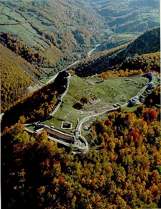
The Manasija Monastery also known as Resava, is a Serbian Orthodox monastery near Despotovac, Serbia founded by Despot Stefan Lazarević between 1406 and 1418. The church is dedicated to the Holy Trinity. It is one of the most significant monuments of medieval Serbian culture and it belongs to the "Morava school". The monastery is surrounded by massive walls and towers. Following its foundation, the monastery became the cultural centre of the Serbian Despotate. Its School of Resava was well known for its manuscripts and translations throughout the 15th and 16th centuries. Manasija complex was declared Monument of Culture of Exceptional Importance in 1979, and it is protected by Republic of Serbia, and the monastery entered the UNESCO Tentative List Process in 2010.
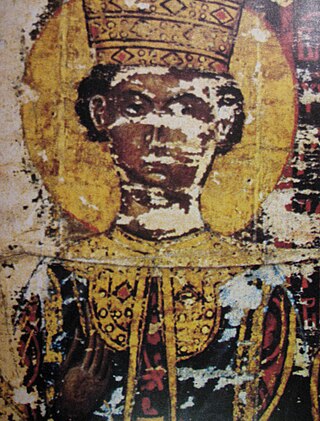
Irene Kantakouzene, known simply as Despotess Jerina, was the wife of Serbian Despot Đurađ Branković. In Serbian folk legends, she is the founder of many fortresses in Serbia.

Vučje is a town in southern Serbia, located some 15 km south from the city of Leskovac, its municipal seat. The population of the town is 2,865 people. It is known for its archaeological site, Zelen grad, ruins of a medieval town.

Soko Grad, also known as Sokolac, is a medieval city and fortress 2 km east of the spa town of Sokobanja, Serbia. The fortress was declared a Monument of Culture of Great Importance in 1982, and it is protected by Republic of Serbia.
Soko Grad is a former town and medieval fortification near the village of Sokolac, east of Ljubovija, western Serbia. The fortress was notable for never being conquered by an army.
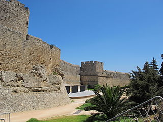
The fortifications of the town of Rhodes are shaped like a defensive crescent around the medieval town and consist mostly of a fortification composed of a huge wall made of an embankment encased in stone, equipped with scarp, bastions, moat, counterscarp and glacis. The portion of fortifications facing the harbour is instead composed of a crenellated wall. On the moles, towers and defensive forts are found.
Jerina's town, Brangović is an archaeological site of an early medieval fortress, located in the village of Brangović, western Serbia. The fort is located on the east bank of the Gradac.

Kurvingrad or Koprijan (Копријан), is a ruined fortress which sits above the town of Doljevac on the South Morava river, 11 km south of the town of Niš. The ruins are all that remain of the medieval town of Koprijan from the time of Classical antiquity; the fortress is over a thousand years old. Today, fortifications remain, but have not been substantially studied.

Rogoi is a Byzantine castle in Nea Kerasounta near Preveza, in western Greece. It is located on the site of the ancient city of Bouchetion (Βουχέτιον), which was abandoned in the late 1st century BC. Re-occupied in the 9th century, it became a bishopric and was refortified, playing an important role in the region's history in the 14th and early 15th centuries. It was abandoned again after the Ottoman conquest in 1449.

Mileševac fortress is a medieval fortification located in southwestern Serbia, 7 km east from the present day town of Prijepolje. It is situated on a steep rock overlooking Mileševka River, the Mileševa monastery and the settlement underneath it.

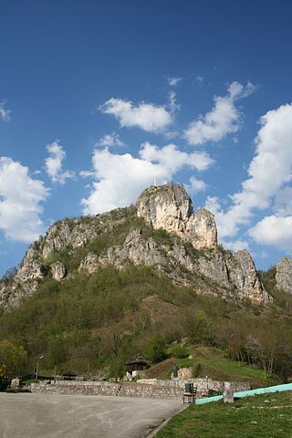
Jeleč is a medieval fortification located in southwestern Serbia, 12 km south of present-day Novi Pazar, on one of the three peaks of Rogozna mountain. Today, the fortification is mostly in ruined state, however there are some well preserved parts.

Borač, also known as Borač na Kršu is a medieval town and fortress. The remains of the Borač fortress lie on top of a rocky hill 10 km northwest of Knić.

Kovin fortress is a strategic fortification in south-western Serbia, 9 km north from the present day town of Prijepolje, between the villages of Džurovo, Kučin, and Izbičanj. The remains are located on a steep rock overlooking the Lim gorge from the left bank, on 698 meters of altitude.


