
Pauri is a town and a municipal board in Pauri Garhwal district in the Indian state of Uttarakhand. Pauri is the seat of the Divisional Commissioner of the Garhwal Division.

Khordha district is an administrative division of the state of Odisha, India. It was formed on April 1, 1993, by the division of former Puri District into Puri, Khordha and Nayagarh districts. In the year 2000 the district name was changed to Khordha. The district headquarters is Khordha Town. The capital city of Bhubaneswar is located in this district. Khordha is the most urbanized of all the districts of Odisha.
Khordha is a town and a Municipality area in Khordha District in the Indian state of Odisha. Bhubaneswar, is the capital of Odisha located within the Khordha district and is only 25 km from Khordha town. Odisha State Highway 1 and National Highway 16 runs via this town.
Balugaon is a town and a Notified Area Council in Khordha district in the state of Odisha, India. It is situated very close to Chilika lake about 90 kilometres (56 mi) from the state capital Bhubaneswar and 76 kilometres (47 mi) from the Berhampur, Ganjam. It is a major economic centre of Khordha district because of its prawn and fish business.
Chak Kashipur is a census town within the jurisdiction of the Nodakhali police station in the Budge Budge II CD block in the Alipore Sadar subdivision of the South 24 Parganas district in the Indian state of West Bengal.

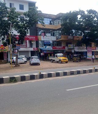
Jatani is a town in the state of Odisha. It is also a municipality in Khordha district in the Indian state of Odisha. Jatani, also known as Khurda Road Junction in Indian Railways parlance, acts as an important railway junction between the main railroads running between Kolkata and Chennai, with diversions to the Hindu pilgrimage town of Puri, and to Daspalla, passing through Khordha & Nayagarh of Odisha. It has emerged as a commercial hub with a number of educational and other institutions. It is home to Premier Public Institutes like NISER and IIT-Bhubaneswar and ICAR- International Centre for Foot and Mouth Disease (ICFMD). Jatni is famous for its celebration of the festival of Ganesh Chaturthi.
Balarampur is a census town in the Budge Budge I CD block in the Alipore Sadar subdivision of the South 24 Parganas district
Tangi is a town and a Notified Area Council in Khordha district in the Indian state of Odisha. It is a major town in Khordha district. It is situated 65 km away from the state capital Bhubaneswar and 38 km away from the district headquarter Khordha.
Kalluvathukkal is a village in the Kollam district of the Indian state of Kerala. NH 47 passes through the village.There ia an Lower primary and Upper primary schools in kalluvathukkal panchayath. And Kalluvathukkal panchayat has its own school, classes from class 5th to 10th standard. A small stadium is located next to the school. The nearest towns are Chathannoor and Paripally. The place is infamous for the Kalluvathukkal hooch tragedy, which took place on 21 October 2000 and killed 31 people.
Mukkall village is located in Kalghatgi Tehsil of Dharwad district in Karnataka, India. You may refer it on web by clicking on Mukkall (Google Maps) It is situated at a distance of 10 km from sub-district headquarter Kalghatgi and 43 km away from district headquarter Dharwad and 428 km from State capital Bangalore. Mukkal is the gram panchayat of Mukkall village. The post office related to Mukkall is Kalghatgi. Polity wise it comes under Kalghatgi assembly constituency and as per Lok Sabha it comes ambit of Dharwad constituency.
Jankia is a village in Khordha Tehsil in Khordha district of Odisha state, India. It is 18 km from district headquarters Khordha and 50 km from state capital Bhubaneswar on the Howrah–Chennai National Highway-No-16. It is around 55 km from Puri on the new Jagannath road. Jankia's postal code is 752020 and postal head office is Jankia. Odia is the local language.
Bolagarh is a town and a Notified Area Council in Khordha in the Indian state of Odisha. It is the headquarter of Bolagarh Tehsil. It can be classified as a main-road area as National Highway 224 passes through it.
Katana is a medium size village in Phillaur tehsil of Jalandhar District of Punjab State, India. It is located 2 km away from Apra-Banga road and 3.3 km away from postal head office Apra. The village is 16.7 km away from Phillaur, 42.6 km from Jalandhar, and 121 km from state capital Chandigarh. The village is administrated by a sarpanch who is an elected representative of village as per Panchayati raj (India).
Khanpur is a medium size village in Phillaur tehsil of Jalandhar District of Punjab State, India. The village is administrated by Sarpanch who is elected representative of village. It is situated on Phillaur-Apra road and located 3.8 km away from Nagar, 3 km from census town Apra, 54 km from Jalandhar and 121 km from state capital Chandigarh. Khanpur has postal head office in Dayalpur which is 8 km away from the village.
Sultanpur is a medium size village in Phillaur tehsil of Jalandhar District of Punjab State, India. It is located 3 km from census town Apra, 48 km from Jalandhar through Dhuleta-Apra road and 124 km from state capital Chandigarh. Sultanpur has postal head office in Dayalpur which is 2 km away from the village. The village is administrated by a sarpanch who is an elected representative of village as per Panchayati raj (India).
Raipur Araiyan or Raipur Araian is a medium size village in Phillaur tehsil of Jalandhar District of Punjab State, India. It is situated on Phillaur Nawanshahr Road and located 5.6 km from Nagar, 12.6 km from Phillaur, 55.8 km from Jalandhar and 110 km from state capital Chandigarh. Raipur Araiyan has postal head office in Dayalpur which is 2.8 km away from the village. The village is administrated by a sarpanch who is an elected representative of village as per Panchayati raj (India).
Sailkiyana or Salkiana is a medium size village in Phillaur tehsil of Jalandhar District of Punjab State, India. It is situated on Phillaur Nawanshahr Road and located 6.7 km from Nagar, 13.7 km from Phillaur, 56.9 km from Jalandhar and 108 km from state capital Chandigarh. Sailkiyana has postal head office in Dayalpur which is 2 km away from the village. The village is administrated by a sarpanch who is an elected representative of village as per Panchayati raj (India).
ChakJamal village is located in Sahdai Buzurg block of Vaishali district in Bihar, India. It is situated 1 km away from sub-district headquarter Sahdai Buzurg and 25 km away from district headquarter Hajipur. As per 2009 stats, ChakJamal village is also a gram panchayat.
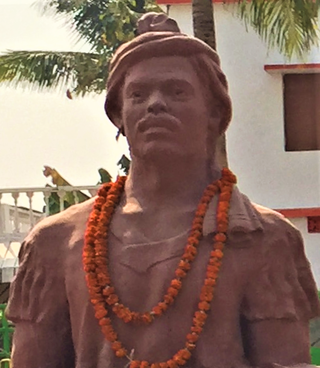
'Samanta' Madhab Chandra Routray was the dalabehera, or the Paika unit commander of Tapanga, in the modern-day Khordha district of Odisha. He led a revolt against British East India Company forces in 1827. With the support of the local community, the warriors under his command withstood the British attack on Tapanga for seven days. He was eventually forced to surrender due to dwindling support, lack of resources, and a lieutenant passing information to the British. However, Routray was later released as the British recognized his stature within the community and the risk of a mass uprising if he were harmed. He earned himself the title of 'Samanta' or 'The commander of Ten Thousand Paikas', which was also given to his forefathers for their military services to the Gajapati king of Khordha.

Ichgam, also known as Ichigam, is a census town located in the Indian administered union territory of Jammu and Kashmir's Budgam district. It falls under the administrative division of tehsil Budgam, one of the nine tehsils of district Budgam. It is one of the most populated area of Budgam district. It is roughly 5 km (3.1 mi) away from district Budgam and nearly 19 km (12 mi) away from Srinagar, the summer capital of union territory of Jammu and Kashmir. Ichgam village consists of four blocks — Ichgam-A, Ichgam-B, Ichgam-C and Ichgam-D. The village consists of both major sects of Islam, Shias (85-90%) and Sunnis(10-15%). There is also a Hindu minority.


