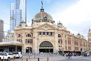
Flinders Street railway station is a train station located on the corner of Flinders and Swanston streets in Melbourne, Victoria, Australia. It is the busiest train station in Australia, serving the entire metropolitan rail network, 15 tram routes travelling to and from the city, as well as some country and regional V/Line services to eastern Victoria. Opened in 1854, the station is the oldest in Australia, backing onto the Yarra River in the central business district, the complex includes 13 platforms and structures that stretch over more than two city blocks, from east of Swanston Street to nearly at Market Street.
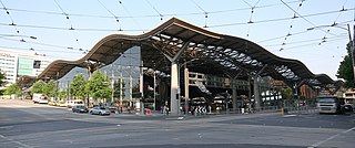
Southern Cross railway station is a major railway station in Docklands, Melbourne. It is on Spencer Street, between Collins and La Trobe streets, at the western edge of the Melbourne central business district. The Docklands Stadium sports arena is 500 metres north-west of the station.

Docklands, also known as Melbourne Docklands, is an inner-city suburb in Melbourne, Victoria, Australia, 2 km (1.2 mi) west of Melbourne's Central Business District, located within the City of Melbourne local government area. Docklands recorded a population of 15,495 at the 2021 census.

Docklands Stadium, known by naming rights sponsorship as Marvel Stadium, is a multi-purpose sports and entertainment stadium in the suburb of Docklands in Melbourne, Victoria, Australia. Construction started in October 1997 and was completed in 2000 at a cost of A$460 million. The stadium features a retractable roof and the ground level seating can be converted from oval to rectangular configuration.

Southbank is an inner-city suburb in Melbourne, Victoria, Australia, 1 km south of the Melbourne central business district, located within the Cities of Melbourne and Port Phillip local government areas. Southbank recorded a population of 22,631 at the 2021 census.

Melbourne Park is a sports venue in the Melbourne Sports and Entertainment Precinct in Melbourne, Victoria, Australia. Since 1988, Australia's bicentenary, Melbourne Park has been home of the Australian Open Grand Slam tennis tournament played annually in January. The park has multiple venues where the Australian Open matches take place. Rod Laver Arena is the largest venue with a capacity of 15,000, while John Cain Arena seats 10,500 and Margaret Court Arena 7,500. The three venues feature retractable roofs, allowing events to be played indoors or outdoors. Besides, there is the Show Court 3 and 1573 Arena which both have a 3,000 seating capacity, and the new 5000-seat Kia Arena. In total there are 35 outdoor Greenset tennis courts at Melbourne Park.

Bourke Street is one of the main streets in the Melbourne central business district and a core feature of the Hoddle Grid. It was traditionally the entertainment hub of inner-city Melbourne, and is now also a popular tourist destination and tram thoroughfare.

James Peter Stynes OAM was an Irish-born footballer who converted from Gaelic football to Australian rules football. Playing for the Melbourne Football Club in the Australian Football League (AFL), he went on to become one of the game's most prominent figures, breaking the record for most consecutive games of VFL/AFL football (244) and winning the sport's highest individual honour, the Brownlow Medal, in 1991. Off the field, he was a notable AFL administrator, philanthropist, charity worker and writer.

Flinders Street is a street in Melbourne, Victoria, Australia. Running roughly parallel to the Yarra River, Flinders Street forms the southern edge of the Hoddle Grid. It is exactly 1 mi (1.6 km) in length and one and a half chains in width.

The Bolte Bridge is a large twin cantilever road bridge in Melbourne, Victoria, Australia. The Bolte Bridge carries a total of eight lanes of traffic – four lanes northbound and four lanes southbound. While officially only 490 metres in length, the actual structure appears much longer as it forms part of a 5 kilometre elevated roadway between Flemington Road and the West Gate Freeway. It spans the Yarra River and Victoria Harbour in the Docklands precinct to the west of the Melbourne CBD. It forms part of the CityLink system of toll roads that connects the Tullamarine Freeway from the northern suburbs with the West Gate Freeway and the Domain and Burnley tunnels to the Monash Freeway and the south eastern suburbs. It is named after Victoria's 38th and longest-serving Premier, Sir Henry Bolte.

Batman's Hill in Melbourne, Australia was named for the Vandemonian adventurer and grazier John Batman. Now removed, the 18-metre-high hill was located to the south of today's Collins Street and Southern Cross railway station, and is the site of a steel marker the same height as the original hill.

Yarra Park is part of the Melbourne Sports and Entertainment Precinct, the premier sporting precinct of Victoria, Australia. Located in Yarra Park is the Melbourne Cricket Ground (MCG) and numerous sporting fields and ovals, including the associated sporting complexes of Melbourne and Olympic Parks. The park and sporting facilities are located in the inner-suburb of East Melbourne. In the late 1850s, many of the earliest games of Australian rules football were played at Yarra Park, which was known at the time as the Richmond Paddock.

Princes Bridge, originally Prince's Bridge, is a bridge in central Melbourne, Australia that spans the Yarra River. It is built on the site of one of the oldest river crossings in the city, and forms a gateway into the central city from the south. The bridge connects Swanston Street on the north bank of the Yarra River to St Kilda Road on the south bank, and carries road, tram and pedestrian traffic. The present bridge was built in 1888 and is listed on the Victorian Heritage Register.

Docklands Highway is an urban highway stretching 12 kilometres from Brooklyn in Melbourne's inner western suburbs to the Docklands precinct, adjacent to the city. This name covers many consecutive streets and is not widely known to most drivers, as the entire allocation is still best known as by the names of its constituent parts: Francis Street, Whitehall Street, Moreland Street, Napier Street, Footscray Road, Dudley Street and Wurundjeri Way. This article will deal with the entire length of the corridor for sake of completion, as well to avoid confusion between declarations.

The Charles Grimes Bridge is a dual-carriageway bridge that carries the Docklands Highway over the Yarra River in the Docklands precinct of Melbourne, Australia. It was named after New South Wales surveyor general Charles Grimes, who was the first European to see the Yarra River.

The Icehouse is an Australian ice sports and entertainment centre, located in the Docklands precinct of Melbourne, in Victoria, Australia. It is open to the public 7 days a week and offers an extensive range of educational ice-skating classes for customers, as well as pathways to ice sports.
The 1991 Brownlow Medal was the 64th year the award was presented to the player adjudged the fairest and best player during the Australian Football League (AFL) home and away season. Jim Stynes of the Melbourne Football Club was declared the outright winner of the medal count, becoming the fifth individual to win the award while playing for Melbourne.
Webb Dock is a port facility at Fishermans Bend in Melbourne, Victoria constructed progressively from 1960, by dredging and land fill at the mouth of the Yarra River. It includes roll-on/roll-off facilities handling motor vehicle import and export and break bulk commodities and a container terminal. The dock is named after John Percival Webb OBE, a former Melbourne Harbor Trust commissioner.

Harbour Esplanade is a waterfront street and thoroughfare in Docklands, an inner suburb of Melbourne, Victoria, Australia. It runs roughly north-south from Navigation Drive in the south to Docklands Drive in the north. The road also forms the eastern boundary of the Victoria Harbour inlet and is adjacent to Victoria Dock.
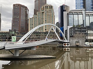
The Evan Walker Bridge is a bicycle and pedestrian bridge over the Yarra River between Southbank and the central business district in Melbourne, Victoria, Australia.

