Jo'ara

Last updated
Building in Jo'ara g'v`rh.jpg
Building in Jo'ara

Jo'ara is a former military installation in the Menashe Heights. A small Palestinian Arab village existed on the hill until the 1930s. Between 1938 and 1948, it became the main military school for commanding officers of the Haganah and Palmach. After the establishment of Israel, the hill was used as a military base and officers school, and between 1970 and 2016 by the Youth Battalions' (Gad'na) pre-military programme. The base and its museum were closed down in 2016–2017. [1]

Contents

Historical settlement

Byzantine period

A grave has been excavated here, yielding coins from Arcadius (395–408) and Theodosius II (408–450). [2]

Ottoman period

During the Ottoman era, a Muslim village called Jarah (lit. "hyena") existed in the area. [3] In 1596 the village appeared under the name of Ja'ara in tax registers, being part of the nahiya (subdistrict) of Sahil Atlit in the Sanjak (district) of Lajjun. It had a population of 4 households, all Muslim. They paid a fixed tax-rate of 25% on agricultural products, including wheat, barley, summer crops, goats and beehives, in addition to occasional revenues; the taxes totalled 2,000 akçe. [4]

During the 19th and first half of the 20th century, Ja'ara was one of the settlements of the so-called "Fahmawi Commonwealth" established by Hebronite clans belonging to Umm al-Fahm. The Commonwealth consisted of a network of interspersed communities connected by ties of kinship, and socially, economically and politically affiliated with Umm al Fahm. The Commonwealth dominated vast sections of Bilad al-Ruha/Ramot Menashe, Wadi 'Ara and Marj Ibn 'Amir/Jezreel Valley during that time. [5]

In 1882, the Palestine Exploration Fund's Survey of Western Palestine described Jarah as "a small village on the east side of the watershed, with four springs below it. There are rock-cut tombs, so that the place seems to be an ancient site." [6] They further noted that the tombs were blocked up. [7] A population list from about 1887 showed that J'arah had about 135 inhabitants, all Muslim. [8]

British Mandate

In the 1922 census of Palestine conducted by the British Mandate authorities, Jaara had a population of 94, all Muslims, [9] decreasing in the 1931 census to 62, still all Muslims, in a total of 14 houses. [10]

In the 1930s, the Jewish National Fund bought the hill and the lands around it from the Salah family, who lived in Haifa and owned the agricultural village. In 1937 Jewish kibbutz members settled the hill, but left a year later, because the area wasn't big enough, [11] to a nearby area and established kibbutz Ein HaShofet. [12]

Jo'ara 1937 hbnyyn h`rby hySHn (g'v`rh) b`yn-hSHvpt-JNF007802.jpeg
Jo’ara 1937

Haganah and Israel Defense Forces base

Jo'ara 1938 AN ARAB BUILDING FORTIFIED BY MEMBERS OF KIBBUTZ EIN HASHOFET IN THE EPHRAIM HILLS. KHvmh vmgdl. bTSylvm, mbnh `rby mbvTSr bqybvTS `yn hSHvpt bhry Aprym..jpg
Jo’ara 1938

From 1938 onwards the hill, which was turned into a base, was used for the Haganah and Palmach commanders and instructors school. [12] Haganah organization set up a training base and main training for the Haganah, in which Some of the commanders and instructors trained here would count among the best future IDF officers, several becoming generals and chiefs of staff, such as Yaakov Dori, Yigael Yadin, Moshe Dayan, Haim Laskov, Tzvi Tzur , Yitzhak Rabin and Haim Bar-Lev. [1]

1948 war

During the 1948 war, the hill was used as the Haganah's base for attacks in the Battle of Mishmar HaEmek.

Training base and officers school (1948-67)

After the war it was used as a training base for the Nahal program that combined military service and the establishment of agricultural settlements. [1]

Between 1950 and 1967 it was used as the Golani Brigade's school for squad commanders. [1]

Youth battalions (Gadna) base (1970-2016)

For 45 years, between 1970 and 2016, the hill served the Israeli Defense Forces' Youth Battalion's one-week familiarisation programme intended on preparing Israeli youth for their military service. High school students from all over Israel used to come to Jo'ara for a week of military training. The week included field craft and weapon training as well as historical and moral courses, all in boot camp conditions and discipline. The teenagers experienced a routine military life, wearing military uniform and obeying orders from their commanders. [1]

Jo'ara was chosen as a Gadna base because the open fields, forests and the hills that surround it are suitable for military training. The base was inaugurated on 9 October 1970 in presence of high ranked IDF generals. In 1991, when the Gadna Command was dismantled and moved to the Education and Youth Corps, the base moved to the command of the Chief Education Officer. [1]

The museum at Jo'ara was presenting the Hagana's officer training courses of 1944, when it reached a record 140 trainees, both men and women. [13]

Related Research Articles

<span class="mw-page-title-main">Umm al-Fahm</span> City in Haifa District, Israel

Umm al-Fahm is a city located 20 kilometres northwest of Jenin in the Haifa District of Israel. In 2021 its population was 57,677, nearly all of whom are Arab citizens of Israel. The city is situated on the Umm al-Fahm mountain ridge, the highest point of which is Mount Iskander, overlooking Wadi Ara. Umm al-Fahm is the social, cultural and economic center for residents of the Wadi Ara and Triangle regions.

<span class="mw-page-title-main">Al-Sarafand</span> Place in Haifa, Mandatory Palestine

Al-Sarafand was a Palestinian Arab village near the Mediterranean shore south of Haifa. In Ottoman tax records, it is shown that the village had a population of 61 inhabitants in 1596. According to a land and population survey by Sami Hadawi, al-Sarafand's population was 290 in 1945, entirely Arab.

Hariss is a village, in the region of South Lebanon.

<span class="mw-page-title-main">Deir Ghazaleh</span> Local Development Committee in Jenin, State of Palestine

Deir Ghazaleh is a Palestinian village in the northern West Bank, located nine kilometers northeast of Jenin in the Jenin Governorate. According to the Palestinian Central Bureau of Statistics, Deir Ghazaleh had a population of over 850 inhabitants in mid-year 2006 and 1,129 in 2017, mostly Muslims with a small Christian minority.

Kafr Dan is a Palestinian village in the Jenin Governorate, located 8 km northwest of Jenin in the northern West Bank. According to the Palestinian Central Bureau of Statistics (PCBS) census, the town had a population of 5,148 in 2007 and 6,591 in 2017.

At-Tayba is a Palestinian village in the West Bank, located 18 km northwest of the city of Jenin in the northern West Bank, and 2 km east of Umm el-Fahm in Israel. According to the Palestinian Central Bureau of Statistics, the town had a population of 2,386 inhabitants in mid-year 2006 and 2,215 in 2017.

Jalamah or Jalameh is a Palestinian village in the West Bank, located 5 km north of the city of Jenin in the northern West Bank. According to the Palestinian Central Bureau of Statistics, the town had a population of 2,304 inhabitants in mid-year 2006 and 2,268 in 2017.

<span class="mw-page-title-main">Meir Shfeya</span> Place in Haifa, Israel

Meir Shfeya is a youth village and agricultural boarding school in northern Israel. Located near Zikhron Ya'akov, it falls under the jurisdiction of Hof HaCarmel Regional Council. In 2021 it had a population of 351.

<span class="mw-page-title-main">'Anin</span> Municipality type D in Jenin, State of Palestine

'Anin is a Palestinian village in the West Bank governorate of Jenin. According to the Palestinian Central Bureau of Statistics, the village had a population of 4,216 inhabitants in 2017.

<span class="mw-page-title-main">Lajjun</span> Depopulated Palestinian village near Jenin

Lajjun was a large Palestinian Arab village located 16 kilometers (9.9 mi) northwest of Jenin and 1 kilometer (0.62 mi) south of the remains of the biblical city of Megiddo. The Israeli kibbutz of Megiddo, Israel was built 600 metres north-east of the depopulated village on the hill called Dhahrat ed Dar from 1949.

<span class="mw-page-title-main">Al-Bira, Baysan</span> Village in Baysan, Mandatory Palestine

Al-Bira, is a depopulated former Palestinian village located 7.5 km north of Baysan. During Operation Gideon, the village was occupied by the Golani Brigade.

<span class="mw-page-title-main">Ibdis</span> Place in Gaza, Mandatory Palestine

'Ibdis was a Palestinian village in the Gaza Subdistrict, located 30 kilometers (19 mi) northeast of Gaza City. It was situated on flat ground on the coastal plain at an elevation of 75 meters (246 ft) above sea level, and bordered by a wadi that bore its name on its eastern side. In 1945, Ibdis had a population of 540 and a land area of 4,593 dunams, of which 18 dunams were built-up areas.

<span class="mw-page-title-main">Sirin, Baysan</span> Place in Baysan, Mandatory Palestine

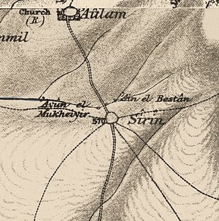
Sirin, was a Palestinian Arab village located 17 kilometers (11 mi) north of Beisan. The village was depopulated and destroyed in 1948. Only the village cemetery and one house remain standing, along with the remains of a mosaic pavement and a vaulted spring dating to the Byzantine period. Mentioned in historical documents, the 1596 census indicated it had 45 households; by 1945, the number of inhabitants had risen to 810.

<span class="mw-page-title-main">Al-Kafrayn</span> Village in Haifa, Mandatory Palestine

Al-Kafrayn was a Palestinian village in the Haifa Subdistrict. It was depopulated during the 1947–48 Civil War in Mandatory Palestine on 12 April 1948 as part of the Battle of Mishmar HaEmek. It was located 29.5 km southeast of Haifa.

<span class="mw-page-title-main">Ayn al-Mansi</span> Place in Jenin, Mandatory Palestine

Ayn al-Mansi was a Palestinian Arab village in the District of Jenin of the Mandatory Palestine. It was depopulated as a result of a military attack in mid-April during the 1947–48 Civil War in Mandatory Palestine.

<span class="mw-page-title-main">Nuris</span> Place in Jenin, Mandatory Palestine

Nuris was a Palestinian Arab village in the District of Jenin. In 1945, Nuris had 570 inhabitants. It was depopulated during the 1948 War on 29 May 1948 under Operation Gideon. The Israeli moshav of Nurit was built on Nuris' village land in 1950.

<span class="mw-page-title-main">Musheirifa</span> Place in Haifa, Israel

Al-Musheirifa is an Arab village in Israel's Haifa District. The village is located in the Wadi Ara area of the northern Triangle, 4 kilometres (2.5 mi) northeast of Umm al-Fahm. Since 1996, it has been under the jurisdiction of the Ma'ale Iron local council. In mid-2016 Musheirifa's population was 3472, all of whom are Muslim. The village is divided into four neighborhoods: Ighbarieh, El-Manshya, Jabbarin, and the Old Village. The inhabitants are largely members of the Ighbarieh clan, which inhabits the upper parts of the village, and the Jabbarin clan, which inhabit the lower parts. Bayada was a neighborhood of the village in the past but split from it and became a new village. The village has poor infrastructure and, like many other villages in the Wadi Ara region, lacks many social institutions and recreational areas.

<span class="mw-page-title-main">Jatt, Israel</span> Local council in Israel

Jatt is an Arab local council in the Triangle area of Haifa District in Israel. In 2021 it had a population of 12,473.

<span class="mw-page-title-main">Mu'awiya, Basma</span> Place

Mu'awiya is an Arab village in Israel's Haifa District. The village is in the Wadi Ara area of the northern Triangle and lies between Kfar Kara and Umm el-Fahm. The village has around 3,100 residents. Since 1996, it has been under the jurisdiction of the Basma local council. The village is divided into two neighborhoods: eastern and western. The residents of the village belong to two clans: Ighbarieh and Mahmid.

'Arabbuna is a Palestinian village in the West Bank governorate of Jenin. The village is located 9 km north of the city of Jenin, south of the West Bank separation barrier and according to the Palestinian Central Bureau of Statistics (PCBS) the village had a population of 1,025 in 2017. Prehistoric flint tools from the Upper and Middle Paleolithic period were found south of the village. Archaeological remains from the Byzantine era were found in the village. It is offered as the location of settlement called "Araba", mentioned by Eusebius in the 4th century CE.

References

  1. 1 2 3 4 5 6 Alon, Eli (3 October 2016). "Jo'ara Gadna Base Will Close Soon" (in Hebrew).
  2. Dauphin, 1998, p. 702
  3. Palmer, 1881, p. 146
  4. Hütteroth and Abdulfattah, 1977, p. 158
  5. Marom, Roy; Tepper, Yotam; Adams, Matthew J. (2024-01-03). "Al-Lajjun: a Social and geographic account of a Palestinian Village during the British Mandate Period". British Journal of Middle Eastern Studies: 8–11. doi:10.1080/13530194.2023.2279340. ISSN   1353-0194.
  6. Conder and Kitchener, 1882, SWP II, p. 42
  7. Conder and Kitchener, 1882, SWP II, p. 54
  8. Schumacher, 1888, p. 181
  9. Barron, 1923, Table XI, Sub-district of Haifa, p. 34
  10. Mills, 1932, p. 92
  11. Levi, Eyal (29 December 2017). "ג'וערה הוא הווסט פוינט של המדינה, בושה שלא ממשיכים את המסורת [Jo'ara is the "west point" of Israel, shame the tradition is not continued]". Ma'ariv .
  12. 1 2 Shpigel, Noa (30 October 2017). "פריצה לבסיס ג'וערה הנטוש הציתה תקווה לפתיחתו מחדש של מוזיאון ההגנה [Break to the abandoned Jo'ara base brought hope for re-opening of a Haganah museum]". Haaretz .
  13. Lydia Aisenberg, A small museum tells a big story: The Joara museum offers visitors a chance to experience a pre-State Hagana officers' training course. The Jerusalem Post, 1 February 2007, accessed 28 December 2019

Bibliography

32°35′45″N35°6′04″E / 32.59583°N 35.10111°E / 32.59583; 35.10111