
El Dorado County, officially the County of El Dorado, is a county located in the U.S. state of California. As of the 2020 census, the population was 191,185. The county seat is Placerville. The county is part of the Sacramento-Roseville-Arden-Arcade, CA Metropolitan Statistical Area. It is located entirely in the Sierra Nevada, from the historic Gold Country in the western foothills to the High Sierra in the east. El Dorado County's population has grown as Greater Sacramento has expanded into the region. Where the county line crosses US 50 at Clarksville, the distance to Sacramento is 15 miles. In the county's high altitude eastern end at Lake Tahoe, environmental awareness and environmental protection initiatives have grown along with the population since the 1960 Winter Olympics, hosted at the former Squaw Valley Ski Resort in neighboring Placer County.

Douglas County is a county in the northwestern part of the U.S. state of Nevada. As of the 2020 census, the population was 49,488. Its county seat is Minden. Douglas County comprises the Gardnerville Ranchos, NV Micropolitan Statistical Area, which is also included in the Reno–Carson City–Fernley, NV Combined Statistical Area.

Placerville is a city in and the county seat of El Dorado County, California. The population was 10,747 as of the 2020 census, up from 10,389 as of the 2010 census. It is part of the Sacramento–Arden-Arcade–Roseville Metropolitan Statistical Area.

South Lake Tahoe is the most populous city in El Dorado County, California, United States, in the Sierra Nevada mountains. The city's population was 21,330 at the 2020 census, down from 21,403 at the 2010 census. The city, along the southern edge of Lake Tahoe, extends about 5 miles (8 km) west-southwest along U.S. Route 50, also known as Lake Tahoe Boulevard. The east end of the city, on the California–Nevada state line right next to the town of Stateline, Nevada, is mainly geared towards tourism, restaurants, hotels, and Heavenly Mountain Resort with the Nevada casinos just across the state line in Stateline. The western end of town is mainly residential, and clusters around "The Y", the X-shaped intersection of US 50, State Route 89, and the continuation of Lake Tahoe Boulevard after it loses its federal highway designation.

Lake Tahoe is a freshwater lake in the Sierra Nevada of the Western United States, straddling the border between California and Nevada. Lying at 6,225 ft (1,897 m) above sea level, Lake Tahoe is the largest alpine lake in North America, and at 122,160,280 acre⋅ft (150.7 km3) it trails only the five Great Lakes as the largest by volume in the United States. Its depth is 1,645 ft (501 m), making it the second deepest in the United States after Crater Lake in Oregon.
John Albert Thompson, nicknamed Snowshoe Thompson, an early resident of the Sierra Nevada of Nevada and California, was a Norwegian-American considered to be the father of California skiing.

Eldorado National Forest is a U.S. National Forest located in the central Sierra Nevada mountain range, in eastern California.

Area code 530 is a telephone area code in the North American Numbering Plan (NANP) in northeastern and Northern California. It was created in 1997 in an area code split of 916.

Fallen Leaf Lake is a mountain lake located in El Dorado County, California, near the California–Nevada state border, about one mile south west of the much larger Lake Tahoe. It is approximately aligned north-to-south and oval in shape, measuring approximately 2.9 miles (4.6 km) on the long axis and 0.9 miles (1.4 km) on the short axis. The lake was created by at least two glaciers that traveled northward down the Glen Alpine Valley. If the glacier had continued instead of stopping, Fallen Leaf Lake would be a bay of Lake Tahoe, similar to nearby Emerald Bay. A terminal moraine is visible at the north end of the lake on the northeast edge.

U.S. Route 50 (US 50) is a transcontinental United States Numbered Highway, stretching from West Sacramento, California, in the west to Ocean City, Maryland, in the east. The California portion of US 50 runs east from Interstate 80 (I-80) in West Sacramento to the Nevada state line in South Lake Tahoe. A portion in Sacramento also has the unsigned designation of Interstate 305. The western half of the highway in California is a four-or-more-lane divided highway, mostly built to freeway standards, and known as the El Dorado Freeway outside of downtown Sacramento. US 50 continues as an undivided highway with one eastbound lane and two westbound lanes until the route reaches the canyon of the South Fork American River at Riverton. The remainder of the highway, which climbs along and out of the canyon, then over the Sierra Nevada at Echo Summit and into the Lake Tahoe Basin, is primarily a two-lane road.
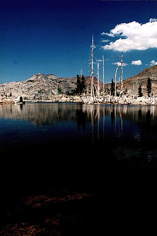
Lake Aloha is a large shallow backcountry reservoir located at an elevation of 8,116 feet in the Sierra Nevada Range, west of Lake Tahoe in El Dorado County, in eastern California.

The Camino, Placerville and Lake Tahoe Railroad was an 8-mile (13 km) Class III short-line railroad operating in the Sierra Nevada in California, east of Sacramento. It was built primarily to haul lumber from the El Dorado National Forest. The standard gauge line ran west 8.05 miles (12.96 km) from a sawmill at Camino to a connection with the Placerville Branch of the Southern Pacific Company at Placerville. Loaded cars of lumber descended a 3.5 percent grade from 3,150 feet (960 m) at Camino to 1,900 feet (580 m) at Placerville.

Sierra-at-Tahoe is a ski and snowboard resort in Twin Bridges, California south of Lake Tahoe. Sierra-at-Tahoe is approximately 16 miles (26 km) south of Stateline, Nevada and 12 miles south of South Lake Tahoe on U.S. Route 50 and is contained within the Eldorado National Forest. Sierra-at-Tahoe is a medium-sized ski area in the Lake Tahoe region, and is well known for being a more family oriented resort and also having a high annual snowfall. Sierra-at-Tahoe's terrain is 25 percent beginner, 50 percent Intermediate, and 25 percent advanced.
Luther Pass is a mountain pass in California in the Sierra Nevada, between the Carson River basin to the southeast and Lake Tahoe to the northwest. It is traversed by State Route 89 and lies on the boundary between Alpine County and El Dorado County. The pass crosses a mountain spur that links the Sierra Crest, the main ridge of the Sierra Nevada to the southwest of the pass, with the Carson Range to the northeast.
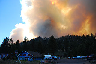
The Angora Fire was a 2007 wind-driven wildfire in El Dorado County, California. It started near North Upper Truckee Road subdivision near Angora Lakes, Fallen Leaf Lake, Echo Lake and South Lake Tahoe, California around 2:15 PM on Sunday, June 24, 2007, as a result of an illegal campfire. As of July 2, 2007, the fire was 100% contained, and 100% control was achieved on July 10. The fire burned 3,100 acres (12.5 km2), destroyed 242 residences and 67 commercial structures, and damaged 35 other homes. At the peak of the fire, there were as many as 2,180 firefighters involved in battling the blaze. The fire cost $13.5 million to fight and caused at least $150 million in property damage.
Meyers is a small unincorporated community in El Dorado County, California, United States, along U.S. Route 50 in the northern Sierra Nevada. It is 6 miles (10 km) south of South Lake Tahoe in the Lake Tahoe area and lies at an elevation of 6,352 feet. Established in 1851, Meyers started out as a stagecoach stop, trading post and Pony Express station. The town is now registered as California Historical Landmark #708. It serves as a popular stop on the way into and out of the Tahoe Basin for travelers on Highway 50 and Highway 89.

Taylor Creek is a 2.2-mile-long (3.5 km) northward-flowing stream originating in the Fallen Leaf Lake and culminating at Baldwin Beach at Lake Tahoe, about 1 mile (1.6 km) west of Camp Richardson in El Dorado County, California.
El Dorado Indian War (1850–1851) was a conflict between Native Americans and miners and California State Militia in what was then the county of El Dorado in California.
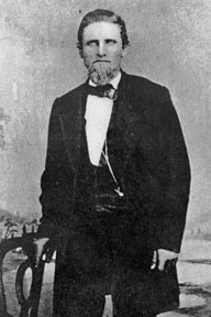
Alexander Howison Murray Jr. (1907–1993), known as Sandy Murray, was a two-time mayor of Placerville, California and three-time president of the county's chamber of commerce, who championed regional development, including the building of U.S. Route 50 in California (US 50) and was a regular page-one name in the Placerville Mountain Democrat.
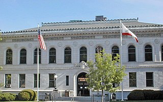
The Superior Court of California, County of El Dorado, also known as the El Dorado County Superior Court, is the branch of the California superior court with jurisdiction over El Dorado County.