Related Research Articles

County Donegal is a county of Ireland in the province of Ulster and in the Northern and Western Region. It is named after the town of Donegal in the south of the county. It has also been known as County Tyrconnell or Tirconaill, after the historic territory. Donegal County Council is the local council and Lifford is the county town.

Portstewart is a small town in County Londonderry, Northern Ireland. It had a population of 7,854 people in the 2021 Census. It is a seaside resort neighbouring Portrush. Its harbour and scenic coastal paths form an Atlantic promenade leading to a two-miles beach, popular with holidaymakers in summer and surfers year-round.
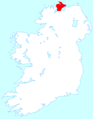
Inishowen is a peninsula in the north of County Donegal in Ireland. Inishowen is the largest peninsula on the island of Ireland.

Buncrana is a town in County Donegal, Ireland. It is beside Lough Swilly on the Inishowen peninsula, 23 kilometres (14 mi) northwest of Derry and 43 kilometres (27 mi) north of Letterkenny. In the 2022 census, the population was 6,971, making it the second most populous town in County Donegal, after Letterkenny, and the largest in Inishowen.
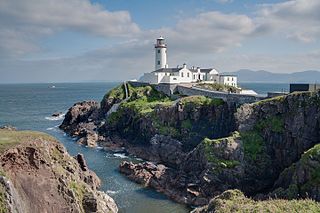
Fanad is a peninsula that lies between Lough Swilly and Mulroy Bay on the north coast of County Donegal, Ireland. The origin of the name Fanad derives from the Irish language word Fána for "sloping ground". It is also referred to as Fannet or Fannett in older records. There are an estimated 700 people living in Fanad and 30% Irish speakers.
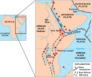
The East African Rift (EAR) or East African Rift System (EARS) is an active continental rift zone in East Africa. The EAR began developing around the onset of the Miocene, 22–25 million years ago. It was formerly considered to be part of a larger Great Rift Valley that extended north to Asia Minor.

The O'Doherty family of County Donegal is an Irish clan who were a prominent sept of the Northern Uí Néill's Cenél Conaill, and one of the most powerful clans of Tír Connaill.

The Caledonian orogeny was a mountain-building cycle recorded in the northern parts of the British Isles, the Scandinavian Caledonides, Svalbard, eastern Greenland and parts of north-central Europe. The Caledonian orogeny encompasses events that occurred from the Ordovician to Early Devonian, roughly 490–390 million years ago (Ma). It was caused by the closure of the Iapetus Ocean when the Laurentia and Baltica continents and the Avalonia microcontinent collided.
The Dalradian Supergroup is a stratigraphic unit in the lithostratigraphy of the Grampian Highlands of Scotland and in the north and west of Ireland. The diverse assemblage of rocks which constitute the supergroup extend across Scotland from Islay in the west to Fraserburgh in the east and are confined by the Great Glen Fault to the northwest and the Highland Boundary Fault to the southeast. Much of Shetland east of the Walls Boundary Fault is also formed from Dalradian rocks. Dalradian rocks extend across the north of Ireland from County Antrim in the north east to Clifden on the Atlantic coast, although obscured by younger Palaeogene lavas and tuffs or Carboniferous rocks in large sections.

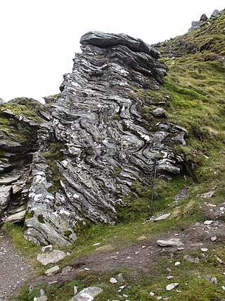
A joint is a break (fracture) of natural origin in a layer or body of rock that lacks visible or measurable movement parallel to the surface (plane) of the fracture. Although joints can occur singly, they most frequently appear as joint sets and systems. A joint set is a family of parallel, evenly spaced joints that can be identified through mapping and analysis of their orientations, spacing, and physical properties. A joint system consists of two or more intersecting joint sets.

Urris is a valley to the west of the parish of Clonmany, in County Donegal, Ireland. It comprises the townlands of Crossconnell, Dunaff, Kinnea, Leenan, Letter, and Urrismenagh. It sits on the eastern side of Loch Swilly and it is bounded to the south-east by the Urris hills, and to the east by Binion hill. To the north, there is Rockstown bay and Tullagh peninsula. There are two entrances to Urris; the Gap of Mamore, and Crossconnell.
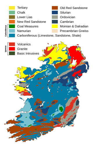
The geology of Ireland consists of the study of the rock formations on the island of Ireland. It includes rocks from every age from Proterozoic to Holocene and a large variety of different rock types is represented. The basalt columns of the Giant's Causeway together with geologically significant sections of the adjacent coast have been declared a World Heritage Site. The geological detail follows the major events in Ireland's past based on the geological timescale.

Henry Hutchinson Montgomery was an Anglican bishop and author.

Mongavlin Castle also known as Mongevlin Castle is a ruined castle on the west bank of the River Foyle, approx 3 km south of St Johnston, County Donegal, Ireland. It was once a stronghold of the O'Donnells, Lords of Tyrconnell.
Sir Hugh McManus O'Donnell was an Irish Gaelic lord. He was The O'Donnell of his clan, and king of Tyrconnell in Tudor-era Ireland.

Bernard Elgey Leake is an English geologist. He is Emeritus Professor of Geology at the University of Glasgow, was Leverhulme Emeritus Fellow at Cardiff University 2000-2002 and has been an Honorary Research Fellow at Cardiff University since 1997.
Sir William John Pugh was a British geologist who was director of the Geological Survey of Great Britain and of the Museum of Practical Geology, Department of Scientific and Industrial Research.

Mercedes Carey was a British professional swimmer. She was the first known person to swim the Straits of Gibraltar and the first British woman to swim the English Channel. The name of Mercedes Gleitze was used to market Rolex's new waterproof case, the "Oyster". She established endurance records for swimming including a record of 46 hours in 1932. She was able to raise funds to found the Mercedes Gleitze Homes in Leicester via sponsorship. The Mercedes Gleitze charity is now linked to the Family Action charity.
The Donegal batholith is a large granitic igneous intrusion of early Devonian age that outcrops in County Donegal in Ireland. It consists of at least eight separate plutons, the largest of which is the Main Donegal Granite. It was intruded at a late stage in the Caledonian orogeny about 400 million years ago (Ma).
Shrove is a coastal hamlet and townland in Inishowen in the north of County Donegal in the north of Ulster, the northern province in Ireland. The hamlet is located a short distance to the north of Greencastle in the north-east of Inishowen, a peninsula on the north coast of Ireland. The name of both the hamlet and the townland is also sometimes written as Shroove, and is sometimes written as Stroove by some government bodies.
References
- ↑ Roberts, John (Summer 1961). "Feather fracture and the mechanics of rock jointing". American Journal of Science. 259: 481–492. doi:10.2475/ajs.259.7.481.
- 1 2 Roberts, John (1972). "Minor thrust faults in the Avonian of the North Crop of the South Wales Coalfield". Geological Journal. 8 (Part 1): 23–28. doi:10.1002/gj.3350080103.
- ↑ "Fracture surface markings in Liassic limestone at Lavernock Point, South Wales". Geological Society, London, Special Publications. 92: 175–186. doi:10.1144/gsl.sp.1995.092.01.09.
- ↑ Allen, P (1981). "Devonian lake margin environments and processes, S.E. Shetland". Journal of the Geological Society. 138: 1–14. doi:10.1144/gsjgs.138.1.0001.
- ↑ Roberts, John (1974). "Jointing and minor tectonics of the Vale of Glamorgan between Ogmore-By-Sea and Lavernock Point, S.Wales". Geological Journal. 9 (Part 2): 97–114. doi:10.1002/gj.3350090201.
- ↑ Roberts, John (1975). "Jointing and minor tectonics of the South Crop of the South Wales Coalfield between Machen and Bridgend". Geological Journal. 10 (2): 147–160. doi:10.1002/gj.3350100204.
- ↑ Roberts, John (1979). "Jointing and minor tectonics of the South Gower Peninsula between Mumbles Head and Rhosilli Bay, South Wales". Geological Journal. 14 (Part 1): 1–14. doi:10.1002/gj.3350140102.
- ↑ Roberts, John (1981). "Jointing and minor tectonics of the North Crop of the South Wales Coalfield between Kidwelly and the Black Mountain, South Wales". Geological Journal. 16 (1): 45–55. doi:10.1002/gj.3350160105.
- ↑ Roberts, John (1973). "Deformed nodular concretions from the upper Dalradian of Eastern Inishowen, Co. Donegal". Irish Naturalists. 17 (12).
- ↑ Roberts, John (1971). "The structure of the Dalradian rocks between Dunree Head and Inch Island, Western Inishowen, Co. Donegal". Proceedings of the Royal Irish Academy. 71 (71/section B - 10).
| International | |
|---|---|
| National | |