Related Research Articles

Thurston Island is a largely ice-covered, glacially dissected island, 135 nautical miles long and 55 nautical miles wide, lying between Amundsen Sea and Bellingshausen Sea a short way off the northwest end of Ellsworth Land, Antarctica. The island is separated from the mainland by Peacock Sound, which is occupied by the west portion of Abbot Ice Shelf.

The Churchill Mountains is a major range of mountains and associated elevations bordering the western side of the Ross Ice Shelf, between Byrd Glacier and Nimrod Glacier. They are south of the Britannia Range and north of the Geologists Range, Miller Range and Queen Elizabeth Range.

The Prince Charles Mountains are a major group of mountains in Mac. Robertson Land in Antarctica, including the Athos Range, the Porthos Range, and the Aramis Range. The highest peak is Mount Menzies, with a height of 3,228 m (10,591 ft). Other prominent peaks are Mount Izabelle and Mount Stinear. These mountains, together with other scattered peaks, form an arc about 420 km (260 mi) long, extending from the vicinity of Mount Starlight in the north to Goodspeed Nunataks in the south.
The Scott Mountains are a large number of isolated peaks lying south of Amundsen Bay in Enderby Land of East Antarctica, Antarctica. Discovered on 13 January 1930 by the British Australian New Zealand Antarctic Research Expedition (BANZARE) under Sir Douglas Mawson. He named the feature Scott Range after Captain Robert Falcon Scott, Royal Navy. The term mountains is considered more appropriate because of the isolation of its individual features.
The Kyle Hills are a prominent group of volcanic cones, hills, ridges, and peaks that occupy the eastern part of Ross Island, Antarctica, between Mount Terror and Cape Crozier. The hills extend east–west for 8 nautical miles (15 km), rising from sea level at Cape Crozier to about 2,600 metres (8,500 ft) in Mount McIntosh at the western end of the group. Local relief of features is on the order of 200 metres (660 ft).
On the continent of Antarctica, the Aramis Range is the third range south in the Prince Charles Mountains, situated 11 miles southeast of the Porthos Range and extending for about 30 miles in a southwest–northeast direction. It was first visited in January 1957 by Australian National Antarctic Research Expeditions (ANARE) southern party led by W.G. Bewsher, who named it for a character in Alexandre Dumas' novel The Three Musketeers, the most popular book read on the southern journey.
The Carnegie Range is a mountain range in the Churchill Mountains of the Transantarctic Mountains System, in the Ross Dependency of Antarctica.
The Olympus Range is a primarily ice-free mountain range of Victoria Land, Antarctica, with peaks over 2,000 metres (6,600 ft) high, between Victoria Valley and McKelvey Valley on the north and Wright Valley on the south. It is south of the Clare Range and north of the Asgard Range.
Douglas Peak is a peak in Antarctica, 1,525 metres (5,000 ft) high, lying 11 nautical miles (20 km) southwest of Mount Codrington and 8 nautical miles (15 km) east of Mount Marr. It was discovered in January 1930 by the British Australian New Zealand Antarctic Research Expedition under Mawson, and named for Flight Lieutenant E. Douglas, Royal Australian Air Force, a pilot with the expedition.
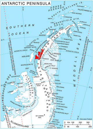
Drummond Glacier is a glacier 10 nautical miles (18 km) long and 2 nautical miles (4 km) wide, on the west coast of Graham Land, situated south of Hopkins Glacier and flowing west-northwest between Voit Peak and Sherba Ridge into Darbel Bay east of Sokol Point.
Mount Falconer is a mountain, 810 metres (2,660 ft) high, surmounting Lake Fryxell on the north wall of Taylor Valley, between Mount McLennan and Commonwealth Glacier in Antarctica. It was named by the Western Journey Party, led by Thomas Griffith Taylor, of the British Antarctic Expedition, 1910–13.
Gage Ridge is a partially snow-covered ridge, 7 nautical miles (13 km) long, standing 2.5 nautical miles (5 km) west of Mount Selwood in the Tula Mountains in Enderby Land, Antarctica. It was plotted from air photos taken from Australian National Antarctic Research Expeditions aircraft in 1956, and was named by the Antarctic Names Committee of Australia for H.V. Gage, a member of the crew of the Discovery during the British Australian New Zealand Antarctic Research Expedition, 1929–31.
The Gonville and Caius Range is a range of peaks, 1,000 to 1,500 metres high, between Mackay Glacier and Debenham Glacier in Victoria Land, Antarctica.
McDonald Ridge is a mostly ice-covered ridge between Johnston Peak and Douglas Peak, about 22 nautical miles (41 km) southeast of Mount Biscoe in Enderby Land, Antarctica. It was plotted from air photos taken from Australian National Antarctic Research Expeditions aircraft in 1956, and was named by the Antarctic Names Committee of Australia for K.R. McDonald, a radio officer at Mawson Station in 1961.
Mount Marr is a rock peak which rises above the surrounding ice surface 8 nautical miles (15 km) south of Johnston Peak and 8 nautical miles (15 km) west of Douglas Peak, in Enderby Land, Antarctica. It was discovered in January 1930 by the British Australian New Zealand Antarctic Research Expedition (BANZARE) under Douglas Mawson and was named after James W.S. Marr, a zoologist on the expedition, whose services were lent to BANZARE by the British Discovery Investigations Committee.
Saint Johns Range is a crescent-shaped mountain range about 20 nautical miles long, in Victoria Land, Antarctica. It is bounded on the north by the Cotton Glacier, Miller Glacier and Debenham Glacier, and on the south by Victoria Valley and the Victoria Upper Glacier and Victoria Lower Glacier.
Stamnen Peak is a peak 1 nautical mile (1.9 km) north of Babordsranten Ridge, near the southwest end of Ahlmann Ridge in Queen Maud Land. Mapped by Norwegian cartographers from surveys and air photos by Norwegian-British-Swedish Antarctic Expedition (NBSAE) (1949–52) and named Stamnen. The ice plain Basissletta lies between Stamnen Peak and Pyramiden Nunatak.

Leroux Bay is a bay 9 nautical miles (17 km) long in a northwest–southeast direction and averaging 5 nautical miles (9 km) wide, between Nunez Point and the narrow Magnier Peninsula surmounted by the Magnier Peaks and Lisiya Ridge, along the west coast of Graham Land, Antarctica. The glaciers Chernomen, Luke and Muldava feed the bay.
The Liljequist Heights are the heights about 2 nautical miles (4 km) south of the Grunehogna Peaks, in the Ahlmann Ridge of Queen Maud Land, Antarctica. They were mapped by Norwegian cartographers from surveys and air photos by the Norwegian–British–Swedish Antarctic Expedition (NBSAE) (1949–52) and air photos by the Norwegian expedition (1958–59). The heights are named for Gösta Hjalmar Liljequist, a Swedish meteorologist with the NBSAE.
References
- ↑ "Johnston Peak". Geographic Names Information System . United States Geological Survey, United States Department of the Interior . Retrieved 2012-07-30.


