
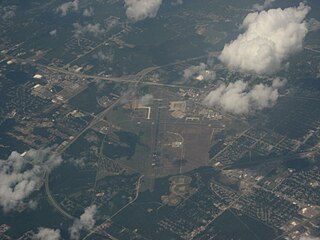
Enid Woodring Regional Airport is a city-owned, public-use airport located four nautical miles southeast of the central business district of Enid, a city in Garfield County, Oklahoma, United States. It is also referred to as Woodring Airport and was formerly known as Enid Woodring Municipal Airport. This airport is included in the National Plan of Integrated Airport Systems for 2011–2015, which categorized it as a general aviation facility. It is mostly used for military training flights based at Vance Air Force Base.

Boone County Airport is a public airport in Boone County, Arkansas. Also known as Boone County Regional Airport, it is four miles northwest of Harrison, Arkansas and serves the surrounding areas including Branson, Missouri. It is used for general aviation and sees one airline, a service subsidized by the federal government's Essential Air Service program at a cost of $2,251,207 per year.

Jonesboro Municipal Airport is located three miles east of Jonesboro, in Craighead County, Arkansas. It is mostly used for general aviation and is served by Southern Airways Express through the federally subsidized Essential Air Service program.

South Arkansas Regional Airport at Goodwin Field is nine miles west of El Dorado, in Union County, Arkansas, United States. It was served by SeaPort Airlines, a service subsidized by the federal government's Essential Air Service program at a cost of $1,977,153. SeaPort Airlines ceased operations on September 20, 2016.
Shreveport Regional Airport is a public use airport in Shreveport, Louisiana, United States. It is owned by the City of Shreveport and located four nautical miles (7 km) southwest of its central business district.

Drake Field is a public airport three miles south of Fayetteville, in Washington County, Arkansas. It is also known as Fayetteville Executive Airport and was formerly Fayetteville Municipal Airport.

Brownwood Regional Airport is six miles north of Brownwood, in Brown County, Texas. The National Plan of Integrated Airport Systems for 2011–2015 categorized it as a general aviation facility. The 21st Cavalry Brigade of the III Corps, U.S. Army use the airport for training in Apache and Blackhawk helicopters.
Natchitoches Regional Airport is a city-owned public-use airport located two nautical miles (4 km) south of the central business district of Natchitoches, a parish seat of Natchitoches Parish, Louisiana, United States.
Ruston Regional Airport is a public use airport in Lincoln Parish, Louisiana, United States. It is owned by the City of Ruston and is located three nautical miles (6 km) east of its central business district.

Deering Airport is a state-owned public-use airport located two nautical miles (3.7 km) southwest of the central business district of Deering, a city in the Northwest Arctic Borough of the U.S. state of Alaska.
Scammon Bay Airport is a state-owned public-use airport located in Scammon Bay, a city in the Kusilvak Census Area of the U.S. state of Alaska.
Hammond Northshore Regional Airport is a city-owned, public-use, joint civil-military, general aviation airport located three nautical miles (6 km) northeast of the central business district of Hammond, a city in Tangipahoa Parish, Louisiana, United States. The airport was previously an uncontrolled facility utilizing VHF-band UNICOM as a Common Traffic Advisory Frequency (CTAF). As a result of the relocation of Army National Guard flight operations from Lakefront Airport to Hammond, a new control tower was constructed at the airport. This tower, staffed by military air traffic controllers from the Air Operations Department of the Louisiana Army National Guard's Army Aviation Support Facility #1 at the airport, became operational on 15 December 2014.
Slidell Airport is a city-owned public-use airport located four nautical miles (7 km) northwest of the central business district of Slidell, a city in St. Tammany Parish, Louisiana, United States.
Abbeville Chris Crusta Memorial Airport is a city-owned, public-use airport located three nautical miles east of the central business district of Abbeville, a city in Vermilion Parish, Louisiana, United States.
Shreveport Downtown Airport is a public use airport located in the Bossier Parish portion of Shreveport, Louisiana, United States. It is closer to downtown Shreveport than the larger Shreveport Regional Airport. It is owned by the Shreveport Airport Authority.
Vivian Airport is a town-owned public-use airport located two nautical miles southwest of the central business district of Vivian, a town in Caddo Parish, Louisiana, United States. The airport is 25 miles north of Shreveport, Louisiana and it is also known as Vivian Municipal Airport.

Shageluk Airport is a state-owned public-use airport located one nautical mile (1.85 km) north of the central business district of Shageluk, a city in the Yukon-Koyukuk Census Area of the U.S. state of Alaska.
St. Tammany Regional Airport is a public use airport in St. Tammany Parish, Louisiana, United States. It is owned by St. Tammany Parish and located six nautical miles southeast of the central business district of Covington, Louisiana. The nearest town is Abita Springs.
False River Regional Airport is a public use airport located two nautical miles northwest of the central business district of New Roads, a city in Pointe Coupee Parish, Louisiana, United States. The airport is owned by New Roads and Pointe Coupee Parish. According to the FAA's National Plan of Integrated Airport Systems for 2009–2013, it was classified as a general aviation airport.
Southland Field is a public-use airport located five nautical miles (9 km) south of the central business district of Sulphur, a city in Calcasieu Parish, Louisiana, United States. It is owned by the West Calcasieu Airport Managing Board and is also known as West Calcasieu Airport.