
Chestonia Township is a civil township of Antrim County in the U.S. state of Michigan. The population was 511 at the 2010 census. From 1901 to 1932, the junction of the East Jordan and Southern and the Detroit & Charlevoix railroads lay within the township.

Jordan Township is a civil township of Antrim County in the U.S. state of Michigan. The population was 992 at the 2010 census.

The St. Joseph River is an 86.1-mile-long (138.6 km) tributary of the Maumee River in northwestern Ohio and northeastern Indiana in the United States, with headwater tributaries rising in southern Michigan. It drains a primarily rural farming region in the watershed of Lake Erie.

The Fawn River is a 55.4-mile-long (89.2 km) river in southwest Michigan and northeast Indiana in the United States. It flows into the St. Joseph River in the city of Constantine, Michigan. The headwaters rise in a series of lakes and marshes in northern Steuben County, Indiana near Pokagon State Park, where it is known as "Crooked Creek" and "Little Fawn River". It flows west-northwest across the northeast corner of LaGrange County, Indiana and then over the state line across the southeast corner of Branch County, Michigan before entering St. Joseph County, Michigan. Passing to the south of Sturgis, Michigan, the river meanders across the state line a few more times before flowing north into Constantine. Except for Constantine, the river does not flow through any large communities, although it passes near Fremont, Indiana, Orland, Indiana, Sturgis, Howe, Indiana, and White Pigeon, Michigan.

Lake Charlevoix is a lake in Charlevoix County in the U.S. state of Michigan. It is the third largest inland lake in the state with a surface area of over 17,200 acres (70 km²) and 56 miles (90 km) of shoreline. The maximum depth in the main basin is 122 feet and in the south arm, 58 feet.

Bear River is a small clear slow-moving river in the U.S. state of Michigan. 14.7 miles (23.7 km) long, it is the largest tributary of Little Traverse Bay in the northwest of the lower peninsula. Traverse Bay is on Lake Michigan. The river is formed as the outflow of Walloon Lake on the boundary between Charlevoix County and Emmet County, draining from the southeast end of the lake at 45°15′40″N84°56′01″W near the community of Walloon Lake in Melrose Township. M-75 has its northern terminus in a junction with US 131 nearby.

Pine River may refer to any of the following rivers in the U.S. state of Michigan:

The Chippewa River is a stream in the U.S. state of Michigan that runs 91.8 miles (147.7 km) through the central Lower Peninsula. The Chippewa is a tributary of the Tittabawassee River and is thus part of the Saginaw River drainage basin. The river is named after the Chippewa people.
Carp River is a 40.2-mile-long (64.7 km) river in Chippewa and Mackinac counties in the U.S. state of Michigan. 21.7 miles (34.9 km) of the river were added to the National Wild and Scenic Rivers System in 1992.
Black River is a 4.2-mile-long (6.8 km) river in the southwest part of the U.S. state of Michigan that empties into Lake Michigan in South Haven at 42°24′08″N86°17′04″W, where it discharges past the South Pier Lighthouse. The river takes its name from the dark brown color of its water, which is caused by suspended sediments and organic materials picked up along its course. The river supports a variety of wildlife including trout, snapping turtles, leeches, and many other varieties of flora and fauna. The Black River watershed encompasses 287 square miles (740 km2) across two counties and 13 townships.

The Cedar River is a 29.0-mile-long (46.7 km) river in the U.S. state of Michigan, flowing through Clare County and Gladwin County.
Cedar River is an 11.6-mile-long (18.7 km) stream in Antrim County in the U.S. state of Michigan and is part of the Elk River Chain of Lakes Watershed, a tributary of Lake Michigan.

The Rocky River is a 28.3-mile-long (45.5 km) stream located in the southwest part of the U.S. state of Michigan that flows into the St. Joseph River at 41°56′33″N85°37′59″W in the city of Three Rivers in St. Joseph County. The Rocky River, along with the St. Joseph River and the Portage River, are the three rivers from which the city of Three Rivers takes its name.
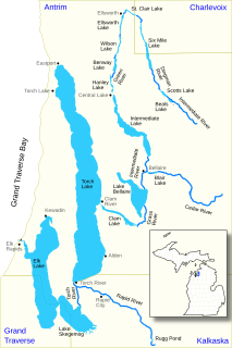
The Elk River Chain of Lakes Watershed is a 75-mile-long (121 km) waterway consisting of 14 lakes and connecting rivers in the northwestern section of the Lower Peninsula of the U.S. state of Michigan, which empty into Lake Michigan.
Boyne River is a stream in Northern Michigan, named for the River Boyne in Leinster, Ireland. Together with the north and south branches, the river system has approximately 22 miles (35 km) of mainstream and the water basin drains 40,320 acres (163.2 km2). Boyne River is Lake Charlevoix's second-largest tributary, after the Jordan River.
Nottawa Creek is a 33.9-mile-long (54.6 km) stream in the U.S. state of Michigan that flows into the St. Joseph River at 42°00′15″N85°23′40″W, approximately three miles east of the village of Mendon.

Sturgeon River is a 40.8-mile-long (65.7 km) river in the U.S. state of Michigan, flowing mostly northward through Otsego and Cheboygan counties.
The Baldwin River is a 25.2-mile-long (40.6 km) stream in the U.S. state of Michigan.
Carp River is a 21.9-mile-long (35.2 km) river in Marquette County in the U.S. state of Michigan. The Carp River is formed by the outflow of Deer Lake in Ishpeming Township north of Ishpeming at 46°31′58″N87°40′01″W in the Upper Peninsula.

