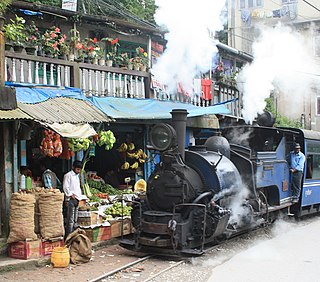
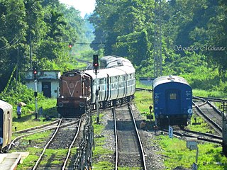
The Darjeeling Himalayan Railway, also known as the DHR or the Toy Train, is a 610 mm gauge railway that runs between New Jalpaiguri and Darjeeling in the Indian state of West Bengal. Built between 1879 and 1881, it is about 88 km (55 mi) long. It climbs from about 100 m (330 ft) above sea level at New Jalpaiguri to about 2,200 m (7,200 ft) at Darjeeling, using six zig zags and five loops to gain altitude. Ghum station is situated at an altitude of 2,258 metres (7,407 ft). Six diesel locomotives handle most of the scheduled service, with daily tourist trains from Darjeeling to Ghum – India's highest railway station – and the steam-hauled Red Panda service from Darjeeling to Kurseong. Steam-enthusiast specials are hauled by vintage British-built B-Class steam locomotives. The railway's headquarters are at Kurseong.

The Northeast Frontier Railway is one of the 19 railway zones of the Indian Railways. It is headquartered in Maligaon, Guwahati in the state of Assam, and responsible for operation and expansion of rail network all across Northeastern states and some districts of eastern Bihar and northern West Bengal.

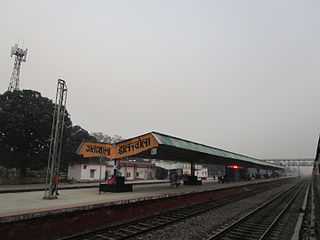
New Jalpaiguri Junction railway station established in 1960, is an A1 category broad-gauge and narrow-gauge railway station under Katihar railway division of Northeast Frontier Railway zone. It is the largest and the busiest railway junction of northeast India. This junction is largest among the railway stations which serve the city of Siliguri, the largest metropolis of the North Bengal. The other stations are- Siliguri Junction, Gulma, Bagdogra, Matigara, Rangapani and Siliguri Town. New Jalpaiguri junction ranked 10th cleanest railway station in India in 2016 survey and came among the top 100 booking stations of Indian railway. New Jalpaiguri, as a railway station serves as the entry point to North Bengal, Sikkim, other countries like Nepal, Bhutan, Bangladesh and the seven northeastern states. New Jalpaiguri Junction acts as a connecting base for the northeastern states to the Indian mainland.

Jorhat is an administrative district of the Indian state of Assam situated in the central part of the Brahmaputra Valley. The district is bounded by Majuli on north, Nagaland state on the south, Sivasagar on the east and Golaghat on the west. On the north of the district, the river Brahmaputra forms the largest riverine island of the world. The administrative seat is at Jorhat city.

Assam is the main and oldest state in the North-East Region of India and as the gateway to the rest of the Seven Sister States. The land of red river and blue hills, Assam comprises three main geographical areas: the Brahmaputra Valley which stretching along the length of the Brahmaputra river, the Barak Valley extending like a tail, and the intervening Karbi Plateau and North Cachar Hills. Assam shares its border with Meghalaya, Arunachal Pradesh, Nagaland, Manipur, Tripura, Mizoram and West Bengal; and there are National Highways leading to their capital cities. It also shares international borders with Bhutan and Bangladesh and is very close to Myanmar. In ancient times Assam was known as Pragjyotisha or Pragjyotishpura, and Kamarupa.

Upper Assam is an administrative division of the state of Assam comprising the undivided Lakhimpur and Sivasagar districts, of the upper reaches of the Brahmaputra valley. The other divisions are: Lower Assam, North Assam and Hills and Barak Valley. The division is under the jurisdiction of a Commissioner, stationed at Jorhat.

The 15657 / 15658 Brahmaputra Mail is a daily train that connects Old Delhi with Kamakhya in Assam. Introduced in 1972 after the construction of the rail section of the Farakka Barrage, the train originally ran as the Tinsukia Mail between Delhi Junction railway station and New Bongaigaon railway stations, with onward metre-gauge connection by a train of the same name numbered as 7Up and 8Dn to Guwahati and Tinsukia in the Indian state of Assam. The train was renamed to Brahmaputra Mail after the successful gauge conversion of the New Bongaigaon–Dibrugarh metre-gauge lines to broad gauge. Later on, w.e.f. 20/12/2020 this train is running between Kamakhya Junction (KYQ) & Old Delhi (DLI) & is permanently cancelled between Kamakhya Junction & Dibrugarh.
Dalkholarailway station is a railway station in Dalkhola, Uttar Dinajpur district, West Bengal, India. It is a standard II-R interlocked roadside station situated on electrified double line section at 43 metres above sea level. It also serves as a prominent rakepoint and the entry to the rest of the NFR zone. Part of the Katihar railway division of Northeast Frontier Railway, the station lies on Howrah–New Jalpaiguri line, Barauni–Guwahati line and Katihar-Siliguri line.

The Howrah–New Jalpaiguri line is a railway line connecting Howrah with New Jalpaiguri in North Bengal in the Indian state of West Bengal. The line continues through North Bengal and western part of Assam to connect with Guwahati. The Naihati–Bandel link allows trains from another terminus Sealdah in Calcutta to use this route. The line uses a major part of the Barharwa–Azimganj–Katwa loop. Many trains use an alternative line between Howrah and New Farakka, via Bardhaman and Rampurhat. Other parts of West Bengal and Bihar are well-connected to this line. It is under the administrative jurisdiction of Eastern Railway and Northeast Frontier Railway.

The New Jalpaiguri–Alipurduar–Samuktala Road line is a railway line that connects New Jalpaiguri- Siliguri Junction with Alipurduar and Samuktala Road in the Indian state of West Bengal. This railway line passes through the beautiful Doars region, which includes Mahananda Wildlife Sanctuary, Dooars-Terai tea gardens, Sevoke Railway Bridge, River Teesta, River Jaldhaka, River Torsha, Gorumara National Park, Buxa Tiger Reserve, Jaldapara National Park, Chapramari Wildlife Sanctuary, Chilapata Forests, Tunnels, Hills, Valleys etc.
The Barauni–Guwahati railway line connects Barauni, Saharsa, Purnia and Katihar in the Indian state of Bihar and Bongaigaon, Kamakhya and Guwahati in Assam via Siliguri, Jalpaiguri, Cooch Behar and Alipurduar in West Bengal. It is a linkage of prime importance for Northeastern India with Capital of india.
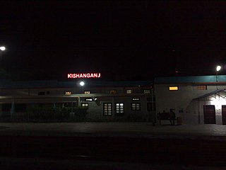
Kishanganj railway station serves Kishanganj city in Kishanganj district in the Indian state of Bihar. It is one of the important railway station, as it lies on the important railway lines, they are Howrah–New Jalpaiguri line, Katihar–Siliguri line, and Barauni–Guwahati line. The famous Gaisal train disaster occurred at Gaisal railway station near Kishanganj.
Golakganj is a railway junction station on the Fakiragram–Dhubri branch line and the New Cooch Behar–Golakganj branch line. A new line is being laid to connect Golakganj with Jogighopa. It is located in Dhubri district in the Indian state of Assam. This station serves the Golakganj town. Important trains like Alipurduar–Silghat Town Rajya Rani Express, Siliguri–Dhubri Intercity Express are available from this station.

Lumding Junction Railway Station serves the Indian city of Lumding in Assam. It is the divisional headquarter of Lumding railway division of NFR. It is located in Hojai district. It is the 2nd biggest railway station of Lumding railway division, after Guwahati. It is one of the oldest railway station in India built under Assam Bengal Railway. It consists of 5 platforms with a total of 68 halting trains & 3 originating trains. The station consists of double diesel line.
Mariani Junction Railway Station is the major railway junction of Jorhat district in the Indian state of Assam on the Lumding–Dibrugarh section. It serves Jorhat city, Mariani and its surrounding area as well. The railway station is located at a distance of 18 km (11 mi) from Jorhat city.

Jorhat is a city and a growing urban centre in the state of Assam in India.
The Rangiya-Murkongselek section is a 450 km (280 mi) long railway line connecting Rangiya in Kamrup district with Murkongselek in Dhemaji district in the Indian state of Assam. The entire section is under the jurisdiction of Northeast Frontier Railway.
New Alipurduar is one of the four railway stations that serve Alipurduar city in Alipurduar district in the Indian state of West Bengal. Its station code is NOQ. The other three adjacent railway stations are Alipurduar Junction, Alipurduar Court and Alipurduar .

Dibru–Sadiya Railway (DSR) was one of the pioneering railway companies in British India and the first railway service of Assam in north-east India.
The New Mal–Changrabandha–New Cooch Behar line are a set of 2 lines which connect Changrabandha, a border transit point near Indo-Bangladesh border in Cooch Behar district with the stations of New Mal in Jalpaiguri district and New Cooch Behar in Cooch Behar district of West Bengal. It is under the jurisdiction of Northeast Frontier Railway. The Malbazar–Changrabandha section of the line was a metre-gauge line, before its gauge conversion began on 2002. The Malbazar–Changrabandha section was re-opened to public on 20 January 2016 after gauge conversion. The New Changrabandha–New Cooch Behar broad-gauge line was built as an extension as a part of the New Maynaguri–Jogighopa rail line to provide an alternate link from North Bengal to Assam and was opened to public on 21 February 2016.