Haryana is an Indian state located in the northern part of the country. It was carved out of the former state of East Punjab on 1 Nov 1966 on a linguistic basis. It is ranked 21st in terms of area, with less than 1.4% of India's land area. The state capital is Chandigarh, which it shares with the neighboring state of Punjab, and the most populous city is Faridabad, which is a part of the National Capital Region. The city of Gurugram is among India's largest financial and technology hubs. Haryana has 6 administrative divisions, 22 districts, 72 sub-divisions, 93 revenue tehsils, 50 sub-tehsils, 140 community development blocks, 154 cities and towns, 7,356 villages, and 6,222 villages panchayats.

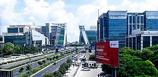
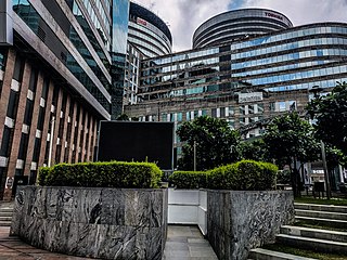
Gurgaon, officially named Gurugram[ɡʊɾʊɡɾaːm], is a planned city and administrative headquarters of Gurugram District, located in the northern Indian state of Haryana. It is situated near the Delhi–Haryana border, about 30 kilometres (19 mi) southwest of the national capital New Delhi and 268 km (167 mi) south of Chandigarh, the state capital. It is one of the major satellite cities of Delhi and is part of the National Capital Region of India. As of 2011, Gurgaon had a population of 1,153,000.

The National Capital Region (NCR) is a planning region centred upon the National Capital Territory (NCT) of Delhi in India. It encompasses Delhi and several districts surrounding it from the states of Haryana, Uttar Pradesh and Rajasthan. The NCR and the associated National Capital Region Planning Board (NCRPB) were created in 1985 to plan the development of the region and to evolve harmonized policies for the control of land-uses and development of infrastructure in the region. Prominent cities of NCR include Delhi, Faridabad, Ghaziabad, Gurugram, and Noida.

Rewari district is one of the 22 districts in the state of Haryana, India. It was carved out of Gurgaon district by the Government of Haryana on 1 November 1989. It is also part of the National Capital Region. The administrative headquarter of the district is the city of Rewari, which is also the biggest city in the district. In medieval times, it was an important market town. It is located in southern Haryana. As of 2011, it is the second least populous district of Haryana after Panchkula.
Faridabad district is one of the 22 districts of the Indian state of Haryana with Faridabad city being the district headquarters. The Delhi-Mathura-Agra National Highway 44 passes through the centre of the district, which occupies an area of 741 square kilometres (286 sq mi) and as of the 2011 census of India had a population of 1,809,733. Haryana government has created a new Faridabad division which would cover the districts – Faridabad, Nuh and Palwal.
Mahendragarh is a city and a municipal committee in Mahendragarh district in the Indian state of Haryana. It is 100 kilometres (62 mi) from Gurgaon and comes under National Capital Region (India).

Gurgaon district, officially known as Gurugram district, is one of the 22 districts of Haryana in northern India. The city of Gurgaon is the administrative headquarters of the district. The population is 1,514,432. It is one of the southern districts of Haryana. On its north, it is bounded by the district of Jhajjar and the Union Territory of Delhi. Faridabad district lies to its east. On its south, lie the districts of Palwal and Nuh. To its west lies Rewari district.
Rohtak is a city and the administrative headquarters of the Rohtak district in the Indian state of Haryana. It lies 70 kilometres (43 mi) north-west of New Delhi and 250 kilometres (160 mi) south of the state capital Chandigarh on NH 9(old NH 10). Rohtak forms a part of the National Capital Region (NCR) which helps the city in obtaining cheap loans for infrastructure development from the NCR Planning Board.

Nuh district is one of the 22 districts in the Indian state of Haryana. There are four sub-divisions in this district: Nuh, Ferozepur Jhirka, Punahana, and Taoru. It has an area of 1,860 square kilometres (720 sq mi) and had a population of 1.09 million in 2011. It is bounded by Gurugram District to the north, Palwal District of Haryana to the east and Alwar District of Rajasthan to the south and west. Its boundaries also touch Bharatpur District of Rajasthan and Mathura District of Uttar Pradesh near Bichhor Village and Nai Village of Punhana Tehsil. It is predominantly populated by farmers of Meo ethnicity.
Dharuhera is a census town located, just 19 km from Rewari city in Rewari district of the state of Haryana, India. Dharuhera comes under Delhi NCR region and it is a big Industrial hub in Rewari District. Dharuhera is the new growth corridor of Gurugram and New Delhi. It is only an hour drive from the Indira Gandhi International Airport and 19 km from Rewari city, the district headquarter, 40 km from Gurugram. It connects Rajasthan to the capital, New Delhi, through the National Highway 48. It is a prime choice for industrialists, investors, and real estate developers due to its location. Dharuhera is located in what is colloquially referred as most prosperous region of Haryana.
Dundahera is a census town in Gurgaon district in the state of Haryana, India. It lies near Udyog Vihar Industrial Area adjacent to Delhi-Gurgaon Border. It has a population of about 122016 persons living in around 2739 households.
Gurgaon Rural is a census town in Gurgaon district in the Indian state of Haryana.

South West Delhi is one of the eleven administrative districts of the National Capital Territory of Delhi in India. Kapashera serves as the administrative headquarters of South West Delhi.

Manesar is a town and municipal corporation, know new Gurugram City in the Gurugram district of the state of Haryana, India and a part of the National Capital Region (NCR) of Delhi. It is an industrial hub.

Palwal district was created on 15 August 2008. It is the 21st district of Haryana state in northern India. Palwal City is the headquarters of the district. It is part of the Braj region.
GSDP of Haryana state was US$85 billion in 2016–17 which had grown at 12.96% CAGR between 2012–17, boosted by the fact that this state on DMIC in NCR contributes 7% of India's agricultural exports and 60% of India's Basmati rice export, with 7 operational SEZs and additional 23 formally approved SEZs also produces India's 67% of passenger cars, 60% of motorcycles, 50% of tractors and 50% of the refrigerators, which places Haryana on 14th place on the list of Indian states and union territories by GDP behind only much bigger states that are significantly larger in both area and population. As per Nov 2016 data, Gurugram ranks number 1 in India in IT growth rate and existing technology infrastructure, and number 2 in startup ecosystem, innovation and livability.
Babupur is a village in Gurgaon Mandal, near sun in Haryana. Babupur is 2940 km from its district main city Gurgaon near Palam Vihar and 252 km from its state main city Chandigarh. It has a population of about 953 persons living in around 185 households.
Bisahan is a village in the Beri tehsil of Jhajjar district of Haryana, India. The village lies roughly 5 kilometres (3.1 mi) from the town of Beri.


