
Lukla is a small town in the Khumbu Pasang Lhamu rural municipality of the Solukhumbu District in the Province No. 1 of northeastern Nepal. Situated at 2,860 metres (9,383 ft) above sea level, it is a popular place for visitors to the Himalayas near Mount Everest to arrive. Although Lukla means "place with many goats and sheep", few are found in the area nowadays.

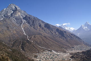
Khumbu is a region of northeastern Nepal on the Nepalese side of Mount Everest. It is part of the Solukhumbu District, which in turn is part of Koshi Pradesh. Khumbu is one of three subregions of the main Kirat Kulung and Sherpa settlement of the Himalaya, the other two being Solu and Pharak. It includes the town of Namche Bazaar as well as the villages of Thame, Khumjung, Pangboche, Pheriche and Kunde. The famous Buddhist monastery at Tengboche is also located in Khumbu.

Kala Patthar is a notable landmark located on the south ridge of Pumori in the Nepali Himalayas above Gorakshep. Although not a proper mountain, with a prominence of only 10 m (33 ft), the ascent of Kala Patthar is very popular with trekkers in the region of Mount Everest since it provides the most accessible closeup view of Everest. Due to the structure of the Everest Massif, its high summit is blocked by Nuptse from much of the surrounding region.
Sagarmāthā Zone was one of the fourteen zones of Nepal until the restructuring of zones into provinces. The headquarters of Sagarmatha is Rajbiraj. Sagarmāthā is a Nepali word which as per some sources, is derived from सगर and माथा.
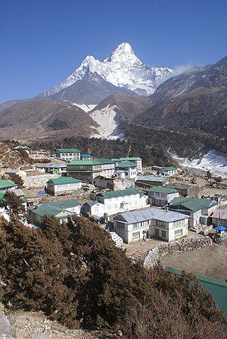
Khumjung is a village in Khumbu Pasanglhamu rural municipality of Solukhumbu District in Province No. 1 of north-eastern Nepal. It is located in the Khumbu sub-region inside Sagarmatha National Park, a world heritage site. The village lies at an elevation of 3,790 metres above sea level, near Mount Khumbila.

Gorak Shep, also spelled Gorakshep, is a settlement nestled on the periphery of a frozen lakebed blanketed with sand in Nepal, sharing its name with the locale. Situated at an elevation of 5,164 meters near Mount Everest, it remains uninhabited for most of the year, reopening only for the Mount Everest trekking season.

Solukhumbu District (Nepali: सोलुखुम्बु जिल्ला, Sherpa: ཤར་ཁུམ་བུ་རྫོང་།, Wylie: shar khum bu dzong) is one of 14 districts of Koshi Province of eastern Nepal. As the name suggests, it consists of the sub-regions Solu and Khumbu. The closest post office to Solukhumbu with a postal code assigned to it is the Sindhuli D.P.O., which has the postal code 56000.

There are two base camps on Mount Everest, on opposite sides of the mountains: South Base Camp is in Nepal at an altitude of 5,364 metres (17,598 ft), while North Base Camp is in Tibet at 5,150 metres (16,900 ft).
Dole is a small village in the Khumbu region of Nepal. It lies in the Dudh Kosi River valley just north of Khumjung and south of Machhermo at an altitude of 4038m.

Chaurikharka is a village development committee in Solukhumbu District in the Sagarmatha Zone of northeastern Nepal. At the time of the 1991 Nepal census it had a population of 2422 people living in 502 individual households.

The Imja Khola is a tributary of the Dudh Kosi river in eastern Nepal. It drains the slopes of Mount Everest. The Khumbu Glacier melts into the Lobujya (Lobuche) River, which flows southward as the Imja Khola to its confluence with the Dudh Kosi at Tengboche.

Syangboche Airport is a domestic airport located in Namche Bazaar serving Solukhumbu District, a district in Koshi Province in Nepal. Syangboche Airport’s first and foremost challenge is its elevation at 3,780 m (12,402 ft); it is exposed to some of the most extreme and capricious weather conditions in the world, with heavy winds, fog and snowfall.

Gokyo is a small village in Solukhumbu District in the Himalayas of Nepal, at the foot of Gokyo Ri and located on the eastern shore of the third Gokyo Lake, Dudh Pokhari. To the southeast is the village of Chharchung. Gokyo is best viewed on Google Earth at 27°57′16″N86°41′43″E.

Machermo is a small village in the Khumbu region of eastern Nepal. It lies in the Dudh Kosi River valley just north of Dole and south of Gokyo at an altitude of 4470m, just below the terminal moraine of the Ngozumpa glacier, the longest glacier in the Himalayas.

Monjo is a small village in the Khumbu region of Nepal. It lies in the Dudh Kosi river valley just north of Phakding and south of Jorsale, at an altitude of 2,835 m, just below the Sagarmatha National Park entrance gate and check-point, one of the UNESCO World Heritage Site since 1979. As per the census of 2011, Monjo village has a population of 114 people. All of them are followers of Buddhism and engaged in the tourism business.

Phakding is a small village in the Khumbu region of Nepal. It lies in the Dudh Kosi river valley just north of Lukla and south of Monjo, at an altitude of 2,610 m. It has been a UNESCO World Heritage Site since 1979. Phakding has a population of 550 locals, mostly Sherpa and Tamang. All of these people belong to Tibetan Buddhism and pray in a small Gompa at the centre of the village.

Kharta is a region in Tibet lying to the east of Mount Everest and centred on the Kharta valley and Kama valley. The 40-kilometre (25 mi) Kharta valley starts at the col at Lhakpa La at the head of the Kharta Glacier from which the Kharta Chu river flows east to join the Phung Chu just beyond Khata village. Nearby to the south, the Kama valley starts at the Kangshung Glacier at the foot of Everest's Kangshung Face, and the Kama Chu flows southeast to the Phung Chu. The 1921 British Mount Everest reconnaissance expedition discovered Kharta when reconnoitring ways to climb Mount Everest and managed to reach the North Col via the Lhakpa La. Since that time Kharta has not been used as a way to approach the summit of Everest but the two valleys have become a popular area for trekking.
After World War II, with Tibet closing its borders and Nepal becoming considerably more open, Mount Everest reconnaissance from Nepal became possible for the first time culminating in the successful ascent of 1953. In 1950 there was a highly informal trek to what was to become Everest Base Camp and photographs were taken of a possible route ahead. Next year the 1951 British Mount Everest reconnaissance expedition reconnoitred various possible routes to Mount Everest from the south and the only one they considered feasible was the one via the Khumbu Icefall, Western Cwm and South Col. In 1952, while the Swiss were making an attempt on the summit that nearly succeeded; the 1952 British Cho Oyu expedition practised high-altitude Himalayan techniques on Cho Oyu, nearby to the west.
The 1951 British Mount Everest reconnaissance expedition ran between 27 August 1951 and 21 November 1951 with Eric Shipton as leader.

Khumbu Pasanglhamu is one of 7 rural municipalities (Gaunpalika) in Solukhumbu district of Province No. 1 of Nepal. Khumjung, Namche & Jubing and Chaurikharka were incorporated while creating it. It has the total population of 9,133 according to the 2011 Nepal census and area of 1,539.11 square kilometres (594.25 sq mi). The admin centre of this gaunpalika is that of the Chaurikharka.
