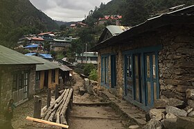
Jiri is a municipality in Dolakha District in the Bagmati Province of central Nepal. At the time of the 2011 Nepal census it had a population of 13,638 people. Jiri, which lies about 190 kilometers from Kathmandu, is the main gateway to the Everest Region. Almost all the Everest expeditions, including the one led by famous climber John Hunt, Edmund Hillary had passed through Jiri. A company of the Nepal Army is stationed in town and visitors' equipment and backpacks might be searched. There are a number of lodges available along either side of the main road mainly in Jiri Bazaar.

Khumbu is a region of northeastern Nepal on the Nepalese side of Mount Everest. It is part of the Solukhumbu District, which in turn is part of Koshi Pradesh. Khumbu is one of three subregions of the main Kirat Kulung and Sherpa settlement of the Himalaya, the other two being Solu and Pharak. It includes the town of Namche Bazaar as well as the villages of Thame, Khumjung, Pangboche, Pheriche and Kunde. The famous Buddhist monastery at Tengboche is also located in the Khumbu.

Kala Patthar is a notable landmark located on the south ridge of Pumori in the Nepali Himalayas above Gorakshep. Although not a proper mountain, with a prominence of only 10 m (33 ft), the ascent of Kala Patthar is very popular with trekkers in the region of Mount Everest since it provides the most accessible closeup view of Everest. Due to the structure of the Everest Massif, its high summit is blocked by Nuptse from much of the surrounding region.

The Khumbu Glacier is located in the Khumbu region of northeastern Nepal between Mount Everest and the Lhotse-Nuptse ridge. With elevations of 4,900 m (16,100 ft) at its terminus to 7,600 m (24,900 ft) at its source, it is the world's highest glacier. The Khumbu Glacier is followed for the final part of the trail to one of the Everest Base Camps. The start of the glacier is in the Western Cwm near Everest. The glacier has a large icefall, the Khumbu Icefall, at the west end of the lower Western Cwm. This icefall is the first major obstacle—and among the more dangerous—on the standard south col route to the Everest summit. It is also the largest glacier of Nepal.

Gorak Shep or Gorakshep is a small settlement that sits on the edge of a frozen lakebed covered with sand in Nepal with the same name. It is found at an elevation of 5,164 metres (16,942 ft) elevation, near Mount Everest. The village is not inhabited year-round.

Solukhumbu District (Nepali: सोलुखुम्बु जिल्ला[solukʰumbu], Sherpa: ཤར་ཁུམ་བུ་རྫོང་།, Wylie: shar khum bu dzong) is one of 14 districts of Koshi Province of eastern Nepal. As the name suggests, it consists of the subregions Solu and Khumbu. The closest post office to Solukhumbu with a postal code assigned to it is the Sindhuli D.P.O., which has the postal code 56000.

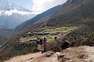
Dingboche (दिङबोचे) 27°53′N86°49′E is a Sherpa village in the Khumbu region of north eastern Nepal in the Chukhung Valley. Its population was estimated at approximately 200 in 2011. It is situated at an altitude of 4,410 metres (14,470 ft).

Sandakphu or Sandakpur is a mountain peak in the Singalila Ridge on the border between India and Nepal. It is the highest point of the ridge and of the state of West Bengal, India. The peak is located at the edge of the Singalila National Park and has a small village on the summit with a few hotels. Four of the five highest peaks in the world, Everest, Kangchenjunga, Lhotse and Makalu can be seen from its summit. It also affords a pristine view of the entire Kangchenjunga Range. Sandakphu is also known as the land of poisonous flowers.

There are two base camps on Mount Everest, on opposite sides of the mountains: South Base Camp is in Nepal at an altitude of 5,364 metres (17,598 ft), while North Base Camp is in China at 5,150 metres (16,900 ft).
Dole is a small village in the Khumbu region of Nepal. It lies in the Dudh Kosi River valley just north of Khumjung and south of Machhermo at an altitude of 4038m.
Mala is a village and Village Development Committee in Kaski District in the Gandaki Zone of northern-central Nepal. At the time of the 1991 Nepal census it had a population of 2,704 persons living in 510 individual households.
Pema Namding Monastery is a Nyingma Tibetan Buddhist monastery in Nepal which was opened in April 2008. Trulsik Rinpoche of Thupten Chholing Monastery named this monastery. Ngawang Jigdral Rinpoche is the founder and Head Lama. It is located in Jubing VDC. Ward No. 09, Kharikhola, Solukhumbu, Nepal. It is located above the Kharikhola village and has a view of the surroundings including Mount Everest.

The Imja Khola is a tributary of the Dudh Kosi in Nepal. It drains the slopes of Mount Everest. The Khumbu Glacier melts into the Lobujya (Lobuche) River, which flows southward as the Imja Khola to its confluence with the Dudh Kosi at Tengboche.

Gokyo is a small village in Solukhumbu District in the Himalayas of Nepal, at the foot of Gokyo Ri and located on the eastern shore of the third Gokyo Lake, Dudh Pokhari. Gokyo Cho. The village is located at an elevation of 4,750 m (15,584 ft), making it one of the highest settlements in Nepal and in the world. Almost all the buildings are guest houses for trekkers. The people who live in the village leave during the winter and move to other (lower) villages such as Namche Bazaar. The village is best viewed on Google Earth at 27°57′16″N86°41′43″E. To the southeast is the village of Chharchung. In 1995, an avalanche killed 42 people, including 17 foreign nationals. A cyclone in the Bay of Bengal had resulted in 6 ft (1.8 m) of snow being dumped into the mountains during the previous week, significantly increasing the avalanche hazard.

Machermo is a small village in the Khumbu region of Nepal. It lies in the Dudh Kosi River valley just north of Dole and south of Gokyo at an altitude of 4470m, just below the terminal moraine of the Ngozumpa glacier, the longest glacier in the Himalayas.

Phakding is a small village in the Khumbu region of Nepal. It lies in the Dudh Kosi river valley just north of Lukla and south of Monjo, at an altitude of 2,610 m, one of the UNESCO World Heritage Site since 1979.

Jorsale is a small village in the Khumbu region of Nepal. It lies in the west side of the Dudh Kosi river, just north of Monjo and south of Namche Bazaar, at an altitude of 2,740 m,

Kharta is a region in Tibet lying to the east of Mount Everest and centred on the Kharta valley and Kama valley. The 40-kilometre (25 mi) Kharta valley starts at the col at Lhakpa La at the head of the Kharta Glacier from which the Kharta Chu river flows east to join the Phung Chu just beyond Khata village. Nearby to the south, the Kama valley starts at the Kangshung Glacier at the foot of Everest's Kangshung Face, and the Kama Chu flows southeast to the Phung Chu. The 1921 British Mount Everest reconnaissance expedition discovered Kharta when reconnoitring ways to climb Mount Everest and managed to reach the North Col via the Lhakpa La. Since that time Kharta has not been used as a way to approach the summit of Everest but the two valleys have become a popular area for trekking.

Lingtren, 6,749 metres (22,142 ft), is a mountain in the Mahalangur Himal area of Himalaya, about 8 kilometres (5.0 mi) distant in a direct line from Mount Everest. It lies on the international border between Nepal and the Tibet Autonomous Region of China and it was first climbed in 1935. A mountain nearby to the west was originally named Lingtrennup but is now more commonly called Xi Lingchain.
After World War II, with Tibet closing its borders and Nepal becoming considerably more open, Mount Everest reconnaissance from Nepal became possible for the first time culminating in the successful ascent of 1953. In 1950 there was a highly informal trek to what was to become Everest Base Camp and photographs were taken of a possible route ahead. Next year the 1951 British Mount Everest reconnaissance expedition reconnoitred various possible routes to Mount Everest from the south and the only one they considered feasible was the one via the Khumbu Icefall, Western Cwm and South Col. In 1952, while the Swiss were making an attempt on the summit that nearly succeeded; the 1952 British Cho Oyu expedition practised high-altitude Himalayan techniques on Cho Oyu, nearby to the west.